Country:
 France
Region:
City:
Latitude and Longitude:
Time Zone:
Postal Code:
IP information under different IP Channel
ip-api
Country
Region
City
ASN
Time Zone
ISP
Blacklist
Proxy
Latitude
Longitude
Postal
Route
IPinfo
Country
Region
City
ASN
Time Zone
ISP
Blacklist
Proxy
Latitude
Longitude
Postal
Route
MaxMind
Country
Region
City
ASN
Time Zone
ISP
Blacklist
Proxy
Latitude
Longitude
Postal
Route
Luminati
Country
FRASN
Time Zone
Europe/Paris
ISP
Electricite de France SA
Latitude
Longitude
Postal
db-ip
Country
Region
City
ASN
Time Zone
ISP
Blacklist
Proxy
Latitude
Longitude
Postal
Route
ipdata
Country
Region
City
ASN
Time Zone
ISP
Blacklist
Proxy
Latitude
Longitude
Postal
Route
Popular places and events near this IP address

Nanterre-Université station
Railway station in Nanterre, France
Distance: Approx. 1249 meters
Latitude and longitude: 48.90138889,2.21472222
Nanterre-Université station is a French railway station on the line from Paris-Saint-Lazare to Saint-Germain-en-Laye, located in the commune of Nanterre. It takes its name from the fact that it is located next to the campus of the Paris Nanterre University. The station is served by trains from Line A of the Réseau Express Régional traveling on the A1 branch to Saint-Germain-en-Laye, as well as by Line L of the Transilien Paris-Saint-Lazare network on the branch to Cergy-le-Haut.
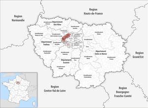
Arrondissement of Nanterre
Arrondissement in Île-de-France, France
Distance: Approx. 875 meters
Latitude and longitude: 48.89444444,2.20333333
The arrondissement of Nanterre is an arrondissement of France in the Hauts-de-Seine department in the Île-de-France region. It has 17 communes. Its population is 900,667 (2019), and its area is 91.8 km2 (35.4 sq mi).
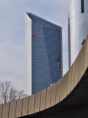
Tour Granite
Office skyscraper in La Défense, the high-rise business district in Paris, France
Distance: Approx. 1199 meters
Latitude and longitude: 48.89179722,2.22958889
Tour Granite is an office skyscraper in La Défense, the high-rise business district situated west of Paris, France. Tour Granite was opened in December 2008. The building is designed by French architect Christian de Portzamparc.
Préfecture des Hauts-de-Seine
Administrative building located in Nanterre
Distance: Approx. 802 meters
Latitude and longitude: 48.89722222,2.21583333
The Préfecture des Hauts-de-Seine is an administrative building located in Nanterre, in the inner suburbs of Paris, France. Designed specifically to host the administrative offices of the préfecture of the Hauts-de-Seine département, the building has a wide base below its 113 m (371 ft)-tall tower.
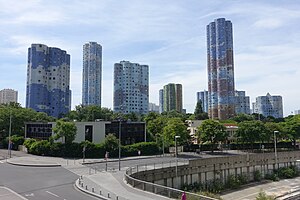
Tours Aillaud
Distance: Approx. 1028 meters
Latitude and longitude: 48.88948889,2.22739167
The Tours Aillaud (also known as Tours Nuages) is a group of residential buildings located in Nanterre, in the inner suburbs of Paris, France. Built in 1976 at the outskirts of La Défense business district, the Tours Aillaud are named after their main architect, Emile Aillaud. The housing project represents 18 towers including 1,607 apartments all together.
Nanterre massacre
2002 mass shooting in Nanterre, France
Distance: Approx. 609 meters
Latitude and longitude: 48.8923,2.2057
The Nanterre massacre was a mass murder that occurred on 27 March 2002, in Nanterre, France. Gunman Richard Durn opened fire at the end of a town council meeting, resulting in the deaths of eight councillors and the injury of nineteen others. Durn committed suicide the following day, by leaping from a police station window during questioning.

Nanterre-Préfecture station
RER train station in the commune of Nanterre, France
Distance: Approx. 935 meters
Latitude and longitude: 48.895631,2.223138
Nanterre–Préfecture station is a RER train station in the commune of Nanterre, west of central Paris, in the department of Hauts-de-Seine in France. The station was opened on 1 October 1973, on the "ligne de St-Germain" connecting Auber and Saint-Germain-en-Laye. It is the westernmost station of the central trunk segment of the RER A. The line splits at this station into multiple branches headed westward; the A1 (to Saint-Germain-en-Laye) and the A3 and A5 branches (to Cergy-le-Haut and Poissy) respectively.
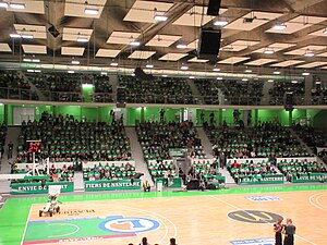
Palais des Sports Maurice Thorez
Indoor sports arena
Distance: Approx. 360 meters
Latitude and longitude: 48.8927441,2.2103631
Palais des Sports Maurice Thorez, or Palais des Sports de Nanterre, is an indoor sporting arena that is located in Nanterre, Hauts-de-Seine, France, near Paris. The arena is named after former minister Maurice Thorez. The capacity of the arena for basketball games is 3,000.
Canton of Nanterre-2
Administrative division of Hauts-de-Seine, France
Distance: Approx. 249 meters
Latitude and longitude: 48.89,2.21
The canton of Nanterre-2 is an administrative division of the Hauts-de-Seine department, in northern France. It was created at the French canton reorganisation which came into effect in March 2015. Its seat is in Nanterre.

L'archipel
Office skyscraper in La Défense's Courbevoie
Distance: Approx. 1200 meters
Latitude and longitude: 48.9001405,2.2197162
L'archipel is an office skyscraper in Nanterre, in La Défense, the business district of the Paris metropolitan area. The building was completed in 2021, it has 24 floors at 106 m.

Nanterre–La Folie station
Railway station in Paris
Distance: Approx. 1120 meters
Latitude and longitude: 48.89877,2.221413
Nanterre–La Folie station is a railway station in Nanterre, Hauts-de-Seine, France. Formerly it was a cargo station of SNCF. It was built as part of the extension of RER E from Haussmann–Saint-Lazare station and opened on 6 May 2024. It connects via a short walk with the Nanterre-Préfecture station on the RER A. From 2030, Nanterre–La Folie will also be a station on Line 15 of the Grand Paris Express extension of the Paris Métro.
Killing of Nahel Merzouk
2023 police shooting in France
Distance: Approx. 1090 meters
Latitude and longitude: 48.8985,2.2213
On 27 June 2023, Nahel Merzouk (25 February 2006 – 27 June 2023), a 17-year-old French youth of Moroccan and Algerian descent, was shot at point-blank range and killed by police officer Florian M. in Nanterre, a suburb of Paris, France. Initial reporting on the incident (informed by police statements) was later contradicted by a video posted online, which led to widespread protests and riots. Symbols of the state such as town halls, schools, police stations, and other buildings were attacked.
Weather in this IP's area
overcast clouds
14 Celsius
14 Celsius
13 Celsius
15 Celsius
1010 hPa
91 %
1010 hPa
1005 hPa
10000 meters
6.17 m/s
200 degree
100 %
07:18:19
20:19:31