192.195.111.95 - IP Lookup: Free IP Address Lookup, Postal Code Lookup, IP Location Lookup, IP ASN, Public IP
Country:
 USA
USARegion:
City:
Location:
Time Zone:
Postal Code:
ISP:
ASN:
language:
User-Agent:
Proxy IP:
Blacklist:
IP information under different IP Channel
ip-api
Country
Region
City
ASN
Time Zone
ISP
Blacklist
Proxy
Latitude
Longitude
Postal
Route
db-ip
Country
Region
City
ASN
Time Zone
ISP
Blacklist
Proxy
Latitude
Longitude
Postal
Route
IPinfo
Country
Region
City
ASN
Time Zone
ISP
Blacklist
Proxy
Latitude
Longitude
Postal
Route
IP2Location
192.195.111.95Country
usRegion
nebraska
City
hastings
Time Zone
America/Chicago
ISP
Language
User-Agent
Latitude
Longitude
Postal
ipdata
Country
Region
City
ASN
Time Zone
ISP
Blacklist
Proxy
Latitude
Longitude
Postal
Route
Popular places and events near this IP address
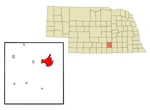
Hastings, Nebraska
City in and county seat of Adams County, Nebraska, United States
Distance: Approx. 2228 meters
Latitude and longitude: 40.59611111,-98.39
Hastings is a city in and the county seat of Adams County, Nebraska, United States. The population was 25,152 at the 2020 census, making it the 8th most populous city in Nebraska. Edwin Perkins invented Kool-Aid in Hastings in 1927; the town celebrates the invention with the Kool-Aid Days festival every August.

Hastings Senior High School (Nebraska)
Public school in Nebraska, United States
Distance: Approx. 2052 meters
Latitude and longitude: 40.60166667,-98.39472222
Hastings High School (HHS) is a public secondary school located in Hastings, Nebraska, United States. It is part of the Hastings Public Schools school district. Other area high schools are St.

KHAS
Radio station in Hastings, Nebraska
Distance: Approx. 1925 meters
Latitude and longitude: 40.57777778,-98.40472222
KHAS (1230 AM) is a radio station broadcasting an adult contemporary format. Licensed to Hastings, Nebraska, United States, the station serves the Grand Island-Kearney area. The station is owned by Flood Communications Tri-Cities, L.L.C. and features programming from CBS News Radio.
Hastings Museum
Distance: Approx. 2225 meters
Latitude and longitude: 40.6001,-98.3915
The Hastings Museum of Natural and Cultural History is located in Hastings, Nebraska. It claims to be the largest municipal museum between Chicago and Denver. It is housed in a building funded by the Works Progress Administration and dedicated on June 15, 1939.

Hastings Municipal Airport
Airport
Distance: Approx. 1709 meters
Latitude and longitude: 40.60527778,-98.42777778
Hastings Municipal Airport (IATA: HSI, ICAO: KHSI, FAA LID: HSI) is two miles northwest of Hastings in Adams County, Nebraska. The National Plan of Integrated Airport Systems for 2011–2015 categorized it as a "general aviation" airport. The first airline flights were Mid-West Airlines Cessna 190s in 1950-51.

St. Mark's Pro-Cathedral (Hastings, Nebraska)
Historic church in Nebraska, United States
Distance: Approx. 2154 meters
Latitude and longitude: 40.58777778,-98.39138889
St. Mark's Pro-Cathedral is an Episcopal Church building located in Hastings, Nebraska, United States. It has been listed on the National Register of Historic Places since 1987.

Chautauqua Pavilion (Hastings, Nebraska)
United States historic place
Distance: Approx. 698 meters
Latitude and longitude: 40.58722222,-98.41222222
The Chautauqua Pavilion is an octagonal pavilion located in Chautauqua Park in Hastings, Nebraska. The pavilion was constructed in 1907 for summer Chautauqua assemblies in Hastings. According to the Historic American Engineering Record, the pavilion's design is unique; in fact, the HAER does not have a name for certain design elements used in the pavilion.

Clarke Hotel
United States historic place
Distance: Approx. 2317 meters
Latitude and longitude: 40.58605,-98.39006667
The Clarke Hotel is a historic hotel in Hastings, Nebraska, included on the National Register of Historic Places in 1987. The Clarke Hotel, named for prominent Hasting businessman Alonzo L. Clarke, originated in 1914 as a project of the Hastings Chamber of Commence and was built through sale of stock to local residents. The architect, C. W. Way, and the construction company, John Hempel Company, were both from Hastings; and local craftsman made everything from the hotel's bricks to its oak millwork and mosaic floors.

William Brach House
United States historic place
Distance: Approx. 2128 meters
Latitude and longitude: 40.5925,-98.39083333
The William Brach House is a historic house in Hastings, Nebraska. It was built in 1884 for William Brach, his wife Charlotte and their two sons, and designed in the Queen Anne architectural style. Brach was a German immigrant and Freemason who settled in Hastings and worked as the manager of a dry goods store called Wolfbach Brothers founded by some of his relatives; and he became its president when it changed its name to Wolbach & Brach in 1907.

Nebraska Loan and Trust Company Building
United States historic place
Distance: Approx. 2253 meters
Latitude and longitude: 40.58555556,-98.39111111
The Nebraska Loan and Trust Company Building, also known as the Clarke-Buchanan Building, is a historic building in Hastings, Nebraska. It was built in 1883, and designed in the Italianate architectural style, although the style "conforms to no major American architectural movement." It was the headquarters of the Nebraska Loan and Trust Company from 1884 to 1903, and the Clarke-Buchanan Company from 1903 to 1931. It has been listed on the National Register of Historic Places since May 1, 1979.

Stein Brothers Building
United States historic place
Distance: Approx. 2440 meters
Latitude and longitude: 40.58527778,-98.38888889
The Stein Brothers Building is a historic building in Hastings, Nebraska. It was built in 1906 for Charles Henry Dietrich, who served as the 11th Governor of Nebraska in 1901 and as a United States Senator from Nebraska from 1901 to 1905. Dietrich rented the building to Herman and Edmund Stein, two brothers who managed a dry goods and hardware store.

Foote Clinic
United States historic place
Distance: Approx. 2291 meters
Latitude and longitude: 40.58777778,-98.38972222
The Foote Clinic is a historic two-story building in Hastings, Nebraska, United States. It was built in 1923-1924 for Dr. Eugene C. Foote, a physician who specialized in the treatment of the eye, the ear, the nose and the throat.
Weather in this IP's area
overcast clouds
-3 Celsius
-7 Celsius
-3 Celsius
-3 Celsius
1010 hPa
80 %
1010 hPa
940 hPa
10000 meters
3.09 m/s
210 degree
100 %