Country:
 Sweden
Region:
City:
Latitude and Longitude:
Time Zone:
Postal Code:
IP information under different IP Channel
ip-api
Country
Region
City
ASN
Time Zone
ISP
Blacklist
Proxy
Latitude
Longitude
Postal
Route
IPinfo
Country
Region
City
ASN
Time Zone
ISP
Blacklist
Proxy
Latitude
Longitude
Postal
Route
MaxMind
Country
Region
City
ASN
Time Zone
ISP
Blacklist
Proxy
Latitude
Longitude
Postal
Route
Luminati
Country
SEASN
Time Zone
Europe/Stockholm
ISP
Tele2 SWIPnet
Latitude
Longitude
Postal
db-ip
Country
Region
City
ASN
Time Zone
ISP
Blacklist
Proxy
Latitude
Longitude
Postal
Route
ipdata
Country
Region
City
ASN
Time Zone
ISP
Blacklist
Proxy
Latitude
Longitude
Postal
Route
Popular places and events near this IP address

Stockholm Arlanda Airport
Main airport serving Stockholm, Sweden
Distance: Approx. 377 meters
Latitude and longitude: 59.65194444,17.91861111
Stockholm Arlanda Airport (IATA: ARN, ICAO: ESSA) is the main international airport serving Stockholm, the capital of Sweden. It is located in Sigtuna Municipality, 37 km (23 mi) north of Stockholm and nearly 40 km (25 mi) southeast of Uppsala. The airport is located within Stockholm County.

Märsta
Place in Uppland, Sweden
Distance: Approx. 5555 meters
Latitude and longitude: 59.61666667,17.85
Märsta (Swedish: [ˈmæ̂ːʂʈa]) is a suburb of Metropolitan Stockholm, a locality and the seat of Sigtuna Municipality, Stockholm County, Sweden with 27,034 inhabitants in 2015. The town is situated close to Stockholm's main international airport, Arlanda. Even though its origins go back to around 500 AD, Märsta is a widespread modern residential area.

Näsby Runestone
Distance: Approx. 7263 meters
Latitude and longitude: 59.63388889,17.79861111
The Näsby Runestone, designated as U 455 under the Rundata catalog, is a Viking Age memorial runestone that is located in Näsby, Uppland, Sweden.

Jumbo Stay
Hostel in Stockholm, Sweden
Distance: Approx. 1395 meters
Latitude and longitude: 59.63986,17.93889
Jumbo Stay (formerly the Jumbo Hostel) is a hostel/hotel located inside a decommissioned Boeing 747-200 aircraft at Stockholm Arlanda Airport, Sweden. She has 33 rooms, 76 beds, and officially opened in January 2009.
Ekeby, Upplands Väsby
Place in Uppland, Sweden
Distance: Approx. 7418 meters
Latitude and longitude: 59.58333333,17.93333333
Ekeby was a locality situated in Upplands Väsby Municipality, Stockholm County, Sweden with 258 inhabitants in 2010.

Uppland Runic Inscription 448
Distance: Approx. 4782 meters
Latitude and longitude: 59.68083333,17.865
This runic inscription, designated as U 448 in the Rundata catalog, is on a Viking Age memorial runestone located in Harg, which is about 4 kilometers north of Märsta, Stockholm County, Sweden, which was in the historic province of Uppland.

Arlanda South Station
Railway station in Sweden
Distance: Approx. 477 meters
Latitude and longitude: 59.64614,17.92822
Arlanda South Station (Swedish: Arlanda södra station) is a railway station on the Arlanda Line serving Stockholm-Arlanda Airport in Sweden. The station is one of two stations at the airport to be served by the Arlanda Express, the other being Arlanda North Station. The station is located inside a tunnel below the airport and is served by four or five trains per hour.

Arlanda North Station
Railway station in Sweden
Distance: Approx. 417 meters
Latitude and longitude: 59.6514,17.9305
Arlanda North Station (Swedish: Arlanda norra station) is a railway station on the Arlanda Line serving Stockholm-Arlanda Airport in Sweden. The station is one of two stations at the airport to be served by the Arlanda Express, the other being Arlanda South Station. The station is located inside a tunnel below the airport and is served by four or five trains per hour.

Midgårdsvallen
Football and track & field stadium in Märsta, Sweden
Distance: Approx. 5873 meters
Latitude and longitude: 59.62055556,17.83694444
Midgårdsvallen is a Football and Track & Field stadium in Märsta, Sweden and the home stadium for the football team Valsta Syrianska IK. The stadium was opened in 2005. The natural grass pitch measures 105 x 65 meters. Currently the Midgårdsvallen stadium is approved for Superettan, but additional flood lights can be installed for Allsvenskan level.

1970 Stockholm Spantax Convair CV-990 crash
Aviation accident in Stockholm, Sweden
Distance: Approx. 2839 meters
Latitude and longitude: 59.62800278,17.89759722
On 5 January 1970, a Convair 990 Coronado operated by the Spanish airline Spantax crashed shortly after take-off from Stockholm Arlanda Airport, killing five of the ten people on board.
Arlandastad Golf
Golfing complex
Distance: Approx. 5875 meters
Latitude and longitude: 59.6011,17.8836
Arlandastad Golf is a 36-hole golfing complex situated near Arlanda Airport 35 km north of Stockholm, Sweden. It has hosted the Scandinavian Masters and SAS Masters on the European Tour.
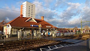
Märsta Station
Railway station in Sigtuna, Sweden
Distance: Approx. 4265 meters
Latitude and longitude: 59.62805556,17.86138889
Märsta is a railway station located in Märsta in Sigtuna Municipality, Stockholm County, Sweden. The station is located 36.5km north of Stockholm C, on the Swedish East Coast Line (Swedish: Ostkustbanan). The station serves long-distance and regional SJ trains, and since 1968 has also been a northern terminus for Stockholm's commuter trains.
Weather in this IP's area
overcast clouds
12 Celsius
12 Celsius
12 Celsius
14 Celsius
1020 hPa
77 %
1020 hPa
1016 hPa
10000 meters
4.63 m/s
180 degree
100 %
07:34:34
17:31:54