192.169.23.144 - IP Lookup: Free IP Address Lookup, Postal Code Lookup, IP Location Lookup, IP ASN, Public IP
Country:
 USA
USARegion:
City:
Location:
Time Zone:
Postal Code:
ISP:
ASN:
language:
User-Agent:
Proxy IP:
Blacklist:
IP information under different IP Channel
ip-api
Country
Region
City
ASN
Time Zone
ISP
Blacklist
Proxy
Latitude
Longitude
Postal
Route
db-ip
Country
Region
City
ASN
Time Zone
ISP
Blacklist
Proxy
Latitude
Longitude
Postal
Route
IPinfo
Country
Region
City
ASN
Time Zone
ISP
Blacklist
Proxy
Latitude
Longitude
Postal
Route
IP2Location
192.169.23.144Country
usRegion
california
City
san ramon
Time Zone
America/Los_Angeles
ISP
Language
User-Agent
Latitude
Longitude
Postal
ipdata
Country
Region
City
ASN
Time Zone
ISP
Blacklist
Proxy
Latitude
Longitude
Postal
Route
Popular places and events near this IP address
Danville, California
City in California, United States
Distance: Approx. 5036 meters
Latitude and longitude: 37.82166667,-122
The Town of Danville is located in the San Ramon Valley in Contra Costa County, California, United States. It is one of the incorporated municipalities in California that use "town" in their names instead of "city". The population was 43,582 at the 2020 census.
San Ramon, California
City in California, United States
Distance: Approx. 12 meters
Latitude and longitude: 37.78,-121.97805556
San Ramon (Spanish: San Ramón, meaning "Saint Raymond") is a city in Contra Costa County, California, United States, located within the San Ramon Valley, and 34 miles (55 km) east of San Francisco. San Ramon's population was 84,605 per the 2020 census, making it the 4th largest city in Contra Costa County, behind Concord, Richmond and Antioch. San Ramon is home to the headquarters of Chevron Corporation, Cooper Companies, the West Coast headquarters of AT&T, GE Digital, as well as the San Ramon Medical Center.

Iron Horse Regional Trail
Multi-use trail in East Bay, California
Distance: Approx. 5490 meters
Latitude and longitude: 37.823961,-122.00604
The Iron Horse Regional Trail is a rail trail for pedestrians, horse riders and bicycles in the East Bay Area in California. This trail is located in inland central Alameda and Contra Costa counties, mostly following a Southern Pacific Railroad right of way established in 1891 and abandoned in 1977. The two counties purchased the right of way at that time, intending to use it as a transportation corridor; the Iron Horse Trail was first established in 1986.

San Ramon Valley
Valley in California, United States of America
Distance: Approx. 4141 meters
Latitude and longitude: 37.75,-121.95
The San Ramon Valley is a valley and region in Contra Costa County and Alameda County, in the East Bay region of the San Francisco Bay Area in northern California.

California High School (San Ramon, California)
Public school in the United States
Distance: Approx. 4643 meters
Latitude and longitude: 37.74666667,-121.94611111
California High School (commonly referred to as Cal High) is one of two public high schools located in San Ramon, California, United States (Dougherty Valley High School is the other). It is one of four high schools in the San Ramon Valley Unified School District and serves students from the western portion of San Ramon and the unincorporated area of Norris Canyon. Its mascot is the grizzly bear.
Bishop Ranch Regional Preserve
Distance: Approx. 2776 meters
Latitude and longitude: 37.75563,-121.97073
Bishop Ranch Regional Preserve (BRRP), also known as Bishop Ranch Regional Open Space Preserve is a 444-acre (1.80 km2) regional park on a ridge top at the edge of San Ramon, California. It is near a residential area, west of San Ramon Valley Road and south of Bollinger Canyon Road. Trails are steep and there are no facilities other than a trailhead.
Sycamore Valley Regional Open Space Preserve
Distance: Approx. 4928 meters
Latitude and longitude: 37.81195,-121.93935
Sycamore Valley Regional Open Space Preserve is a regional park in Contra Costa County, California, outside of Danville, California, United States that is part of the East Bay Regional Parks (EBRPD) system.
San Ramon Valley Fire Protection District
Distance: Approx. 12 meters
Latitude and longitude: 37.78,-121.97805556
The San Ramon Valley Fire Protection District provides fire protection and emergency medical services for the cities of Alamo, Blackhawk, Danville, Diablo, Camino Tassajara and San Ramon as well as southern areas of the Morgan Territory in California, United States. In all, the district is responsible for 155 square miles (400 km2) with a population of approximately 192,800.
Sherburne Hills
Mountain range in California
Distance: Approx. 3242 meters
Latitude and longitude: 37.79742667,-121.94857
The Sherburne Hills are a mountain range in Contra Costa County, California.
Norris Canyon, California
Census-designated place in California, United States
Distance: Approx. 3882 meters
Latitude and longitude: 37.74611111,-121.98888889
Norris Canyon is a census-designated place in Contra Costa County, California. Norris Canyon sits at an elevation of 1063 feet (324 m). The 2010 United States census reported Norris Canyon's population was 957.

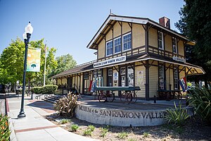
Danville station (California)
United States historic place
Distance: Approx. 4955 meters
Latitude and longitude: 37.82070556,-122.00051111
The Danville Southern Pacific Train Depot in Danville, California is located at 205 Railroad Ave. and W Prospect Ave. It was built in 1891 on land donated by John Hartz which was erected when the Martinez line was extended south to San Ramon.

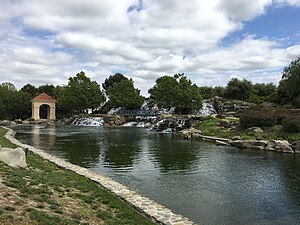
Bollinger Canyon Creek
Creek in Central California
Distance: Approx. 1452 meters
Latitude and longitude: 37.77085,-121.98988
Bollinger Canyon Creek is an approximately 6.72-mile-long (10.8 km) stream in Contra Costa County, California in the San Francisco Bay Area. It is a tributary of San Ramon Creek which is part of the Walnut Creek watershed. The creek derives its name from the surname of a family who settled in the area in the 19th century.
Weather in this IP's area
clear sky
3 Celsius
1 Celsius
1 Celsius
5 Celsius
1022 hPa
67 %
1022 hPa
994 hPa
10000 meters
2.57 m/s
80 degree