192.166.98.39 - IP Lookup: Free IP Address Lookup, Postal Code Lookup, IP Location Lookup, IP ASN, Public IP
Country:
 Netherlands
Region:
City:
Location:
Time Zone:
Postal Code:
ISP:
ASN:
language:
User-Agent:
Proxy IP:
Blacklist:
IP information under different IP Channel
ip-api
Country
Region
City
ASN
Time Zone
ISP
Blacklist
Proxy
Latitude
Longitude
Postal
Route
db-ip
Country
Region
City
ASN
Time Zone
ISP
Blacklist
Proxy
Latitude
Longitude
Postal
Route
IPinfo
Country
Region
City
ASN
Time Zone
ISP
Blacklist
Proxy
Latitude
Longitude
Postal
Route
IP2Location
192.166.98.39Country
nlRegion
zuid-holland
City
noordwijk-binnen
Time Zone
Europe/Amsterdam
ISP
Language
User-Agent
Latitude
Longitude
Postal
ipdata
Country
Region
City
ASN
Time Zone
ISP
Blacklist
Proxy
Latitude
Longitude
Postal
Route
Popular places and events near this IP address

Noordwijk
Municipality in South Holland, Netherlands
Distance: Approx. 334 meters
Latitude and longitude: 52.23333333,4.45
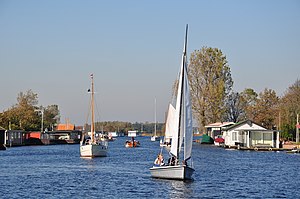
Noordwijk (pronounced [ˈnoːrtʋɛik] ) is a town and municipality in the west of the Netherlands, in the province of South Holland. The municipality covers an area of 74.94 km2 (28.93 sq mi) of which 16.57 km2 (6.40 sq mi) is water and had a population of 44,062 in 2021. On 1 January 2019, the former municipality of Noordwijkerhout became part of Noordwijk.

Voorhout
Place in South Holland, Netherlands
Distance: Approx. 3025 meters
Latitude and longitude: 52.22305556,4.48638889
Voorhout (Dutch pronunciation: [ˈvoːrɦʌut] ) is a village and former municipality in the western Netherlands, in the province of South Holland. The former municipality covered an area of 12.59 km2 (4.86 sq mi) of which 0.33 km2 (0.13 sq mi) is covered by water, and had a population of 14,792 in 2004. Together with Sassenheim and Warmond, it became part of the Teylingen municipality on January 1, 2006.
Teylingen
Municipality in South Holland, Netherlands
Distance: Approx. 3257 meters
Latitude and longitude: 52.21666667,4.48333333
Teylingen (Dutch pronunciation: [ˈtɛilɪŋə(n)] ) is a municipality in the Western Netherlands, in the province of South Holland. It was created on 1 January 2006, through the amalgamation of Sassenheim, Voorhout and Warmond. It is named after Teylingen Castle, located in Voorhout.
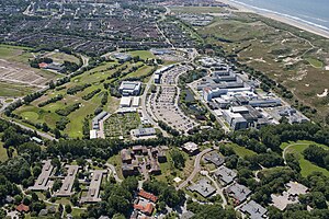
European Space Research and Technology Centre
European Space Agency technology complex
Distance: Approx. 2716 meters
Latitude and longitude: 52.21722222,4.42138889
The European Space Research and Technology Centre (ESTEC) is the European Space Agency's main technology development and test centre for spacecraft and space technology. It is situated in Noordwijk, South Holland, in the western Netherlands, although several kilometers off the village but immediately linked to the most Northern district of the nearby town Katwijk. At ESTEC, about 2500 engineers, technicians and scientists work hands-on with mission design, spacecraft and space technology.
European Cooperation for Space Standardization
Standardization organization for European space activities
Distance: Approx. 2716 meters
Latitude and longitude: 52.21722222,4.42138889
The European Cooperation for Space Standardization (ECSS) is a collaboration between the European Space Agency (ESA), the European space industry represented by Eurospace, and several space agencies, to develop and maintain a coherent, single set of user-friendly standards for use in all European space activities. Established in 1993 following a call by Eurospace to unify space products assurance standardization on a European level, it was officially adopted by the ESA on 23 June 1994 through the resolution ESA/C/CXIII/Res.1, to replace its own Procedures, Specifications and Standards (PSS) system. The ECSS currently has 139 active standards, forming the ECSS system.

Duin- en Bollenstreek
Distance: Approx. 1923 meters
Latitude and longitude: 52.2379,4.4752
The Duin- en Bollenstreek (Dutch pronunciation: [ˈdœyn ɛm ˈbɔlə(n)streːk]; Dutch for "Dune and Bulb Region") is a region in the Western Netherlands, that features coastal dunes and the cultivation of flower bulbs. Situated at the heart of historical Holland nearby the city of Leiden, South Holland, it is bordered by The Hague to the west and Haarlem to the north. The combination of beaches, flower fields, lakes and history makes this area attractive to tourists.

Voorhout railway station
Railway station in the Netherlands
Distance: Approx. 2851 meters
Latitude and longitude: 52.22416667,4.48444444
Voorhout is a railway station located in Voorhout, Netherlands. The station is on the Amsterdam–Rotterdam railway and the first station opened on 15 February 1892. This station closed on 17 September 1944.

De Graaf van het Hoogveen
Restaurant in Noordwijk aan Zee, Netherlands
Distance: Approx. 1534 meters
Latitude and longitude: 52.24765833,4.43573611
De Graaf van het Hoogveen was a restaurant located in Badhotel Zeerust in Noordwijk aan Zee, Netherlands. It was a fine dining restaurant that was awarded one Michelin star in 1982 and retained that rating until 1988. De Graaf van het Hoogveen was a small restaurant with just eight tables.

Latour (restaurant)
Restaurant in Noordwijk, Netherlands
Distance: Approx. 1440 meters
Latitude and longitude: 52.24101667,4.42786389
Latour is a restaurant housed in Grand Hotel Huis ter Duin in Noordwijk, Netherlands. It is a fine dining restaurant that was awarded one Michelin star for the period 2005–present. GaultMillau awarded the restaurant 16 out of 20 points.

Noordwijk Lighthouse
Lighthouse
Distance: Approx. 1698 meters
Latitude and longitude: 52.24872222,4.43397222
Noordwijk Lighthouse (in Dutch: Vuurtoren van Noordwijk aan Zee) is a lighthouse located in Noordwijk, South Holland, Netherlands.

Grand Hotel Huis ter Duin
Distance: Approx. 1444 meters
Latitude and longitude: 52.2414,4.4281
Grand Hotel Huis ter Duin (Dutch: [ˈhœys tər ˈdœyn]) is a seaside hotel and congress center in Noordwijk aan Zee, South Holland, Netherlands, with views over the North Sea. It is notable for being decorated in a clown theme, with many paintings of clowns, and for housing the Michelin-starred Latour restaurant.
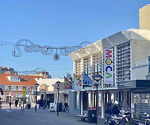
Museum of Comic Art
Museum in Noordwijk, Netherlands
Distance: Approx. 1368 meters
Latitude and longitude: 52.24364,4.43175
The Museum of Comic Art (MoCA) in Noordwijk, The Netherlands, is an international art museum that specializes in original artwork by European and U.S. comic book and newspaper comic artists. Its primary focus are original comic strips and comic book pages by influential artists such as Winsor McCay, Richard Outcault, Hergé, André Franquin, Jijé, Peyo and Morris. There are new exhibitions every summer and winter.
Weather in this IP's area
overcast clouds
3 Celsius
-2 Celsius
3 Celsius
4 Celsius
1024 hPa
76 %
1024 hPa
1023 hPa
10000 meters
8.49 m/s
12.67 m/s
95 degree
100 %