Country:
 Sweden
Region:
City:
Latitude and Longitude:
Time Zone:
Postal Code:
IP information under different IP Channel
ip-api
Country
Region
City
ASN
Time Zone
ISP
Blacklist
Proxy
Latitude
Longitude
Postal
Route
IPinfo
Country
Region
City
ASN
Time Zone
ISP
Blacklist
Proxy
Latitude
Longitude
Postal
Route
MaxMind
Country
Region
City
ASN
Time Zone
ISP
Blacklist
Proxy
Latitude
Longitude
Postal
Route
Luminati
Country
SEASN
Time Zone
Europe/Stockholm
ISP
Telenor Norge AS
Latitude
Longitude
Postal
db-ip
Country
Region
City
ASN
Time Zone
ISP
Blacklist
Proxy
Latitude
Longitude
Postal
Route
ipdata
Country
Region
City
ASN
Time Zone
ISP
Blacklist
Proxy
Latitude
Longitude
Postal
Route
Popular places and events near this IP address
Örebro County
County (län) of Sweden
Distance: Approx. 979 meters
Latitude and longitude: 59.266667,15.216667
Örebro County (Swedish: Örebro län) is a county or län in central Sweden. It borders the counties of Västra Götaland, Värmland, Dalarna, Västmanland, Södermanland and Östergötland. It is frequently culturally divided into the hilly northern region of Bergslagen, where mining and metallurgic industry have been important since the Middle Ages, and the southern Mälardalen of lakes and farms.

Örebro Municipality
Municipality in Örebro County, Sweden
Distance: Approx. 979 meters
Latitude and longitude: 59.26666667,15.21666667
Örebro Municipality (Swedish: Örebro kommun) is a municipality in Örebro County in central Sweden. Its seat is located in the city of Örebro. The municipality was created from the City of Örebro and surrounding rural municipalities in 1971 and with some areas added in 1974 it had an area of 1,840 km2.

Örebro
City in Närke, Sweden
Distance: Approx. 371 meters
Latitude and longitude: 59.27388889,15.2075
Örebro ( UR-ə-BROO, Swedish: [œrɛˈbruː] ) is the sixth-largest city in Sweden, the seat of Örebro Municipality, and capital of Örebro County. It is situated by the Närke Plain, near the lake Hjälmaren, a few kilometers inland along the small river Svartån, and has a population of approximately 126,000 in the city proper. It is one of the largest inland hubs of the country, and a major logistic and commercial operating site.

Örebro Castle
Distance: Approx. 190 meters
Latitude and longitude: 59.27388889,15.21527778
Örebro Castle (Swedish: Örebro slott) is a medieval castle fortification at Svartån in Örebro County, Sweden. It was expanded during the reign of the royal family Vasa (House of Vasa) and finally rebuilt about 1900. Some of the rooms are used as classrooms for pupils from Karolinska gymnasiet.

Eyravallen
Swedish football stadium
Distance: Approx. 1161 meters
Latitude and longitude: 59.26611111,15.22305556
Eyravallen, currently known as Behrn Arena for sponsorship reasons, is a football stadium in Örebro, Sweden and home stadium for Örebro SK in Swedish second division Superettan. The stadium holds 12,645 people and was built in 1923. The stadium underwent renovation between 2003–2009.

Örebro University Hospital
Hospital in Örebro County, Sweden
Distance: Approx. 660 meters
Latitude and longitude: 59.27555556,15.225
Örebro University Hospital (Swedish: Universitetssjukhuset Örebro, USÖ) is a university hospital in Örebro, Sweden. The hospital is operated by Örebro County Council and took its current name in 2000, having previously been called Örebro Regional Hospital. The hospital is one of three hospitals within the Örebro County Region, the others being the Karlskoga Hospital and Lindesberg Hospital.

Örebro Central Station
Railway station in Örebro, Sweden
Distance: Approx. 382 meters
Latitude and longitude: 59.27861111,15.21166667
Örebro Central Station (Swedish: Örebro centralstation) is a railway station in Örebro, Sweden, located north of city center. The station building was designed by architect Adolf W. Edelsvärd and was originally named Örebro Norra (Örebro North Station).

Örebro Concert Hall
Concert hall in Örebro, Sweden
Distance: Approx. 406 meters
Latitude and longitude: 59.2726,15.2086
The Örebro Concert Hall (Swedish: Örebro konserthus) is a concert hall located in Örebro, Sweden. It was built between 1930 and 1932. The hall can accommodate 723 people.

Olaus Petri Church
Church in Örebro, Sweden
Distance: Approx. 638 meters
Latitude and longitude: 59.2803,15.2189
Olaus Petri Church (Swedish: Olaus Petri kyrka) is a church building in Örebro in Sweden. Belonging to the Örebro Olaus Petri Parish of the Church of Sweden, it was opened on Fourth Advent Sunday 1912.
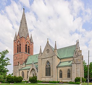
Saint Nicholas Church, Örebro
Church in Örebro, Sweden
Distance: Approx. 363 meters
Latitude and longitude: 59.2722,15.2114
The Saint Nicholas Church (Swedish: Sankt Nikolai kyrka) or the Nicholas Church (Swedish: Nikolaikyrkan) is a church building in central Örebro, Sweden. It was originally called the Örebro Church (Swedish: Örebro kyrka) because it was the only Church of Sweden building in town until the early 20th century. Örebro Nikolai parish is in the Diocese of Strängnäs of the Church of Sweden.

Conventum Arena
Exhibition centre in Örebro, Sweden
Distance: Approx. 833 meters
Latitude and longitude: 59.26916667,15.205
Conventum Arena is a 4,800-square-metre (52,000 sq ft) exhibition centre located in central Örebro, Sweden. The decision on a new exhibition hall in the city was taken around 2005 with construction beginning in January 2007. The arena was completed in March 2008 and was built between Örebro södra station, Scandic Grand Hotel, and Conventum Kongress.

Norra Vattentornet
Swedish water tower
Distance: Approx. 1227 meters
Latitude and longitude: 59.2849,15.224
Norra Vattentornet is a water tower in Örebro, Sweden that opened in 1915, and was closed in 1958. In 1988, the Svampen water tower was opened instead.
Weather in this IP's area
overcast clouds
25 Celsius
25 Celsius
25 Celsius
26 Celsius
1015 hPa
40 %
1015 hPa
1010 hPa
10000 meters
3.98 m/s
6.89 m/s
139 degree
89 %
06:12:41
19:41:10