Country:
Region:
City:
Latitude and Longitude:
Time Zone:
Postal Code:
IP information under different IP Channel
ip-api
Country
Region
City
ASN
Time Zone
ISP
Blacklist
Proxy
Latitude
Longitude
Postal
Route
Luminati
Country
Region
h
City
alem
ASN
Time Zone
Europe/Stockholm
ISP
Telia Company AB
Latitude
Longitude
Postal
IPinfo
Country
Region
City
ASN
Time Zone
ISP
Blacklist
Proxy
Latitude
Longitude
Postal
Route
db-ip
Country
Region
City
ASN
Time Zone
ISP
Blacklist
Proxy
Latitude
Longitude
Postal
Route
ipdata
Country
Region
City
ASN
Time Zone
ISP
Blacklist
Proxy
Latitude
Longitude
Postal
Route
Popular places and events near this IP address

Varberg Municipality
Municipality in Halland County, Sweden
Distance: Approx. 862 meters
Latitude and longitude: 57.1,12.25
Varberg Municipality (Varbergs kommun) is a municipality in Halland County, in southwest Sweden. Its seat is in Varberg. It was formed in 1971 through the amalgamation of the City of Varberg and the surrounding rural municipalities.

Varberg
Place in Halland, Sweden
Distance: Approx. 1903 meters
Latitude and longitude: 57.11666667,12.21666667
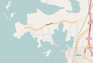
Varberg (Swedish pronunciation: [ˈvɑ̂ːrbærj]) is a locality and the seat of Varberg Municipality, Halland County, Sweden, with 35,782 inhabitants in 2019. Varberg and all of Halland are well known for their "typical west coast" sandy beaches. In Varberg the coast changes from wide sandy beaches to rocky terrain that continues north into the Bohuslän archipelago and as far as the North Cape.

Varberg Fortress
Medieval fortification in Sweden
Distance: Approx. 111 meters
Latitude and longitude: 57.10666667,12.24
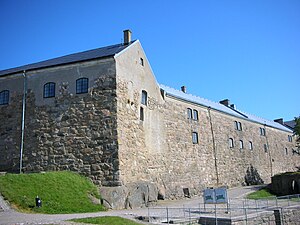
Varberg Fortress (Swedish: Varbergs fästning) is a former fortification in Varberg, Halland County, Sweden, which currently serves as a museum.

Varberg Church
Church in Varberg, Weden
Distance: Approx. 537 meters
Latitude and longitude: 57.10597222,12.25055556
Varberg Church (Swedish: Varbergs kyrka) is situated at the marketplace in Varberg, Halland County, Sweden. The church was completed in 1772, as a replacement of an elder church from 1687 that was destroyed in a fire on 18 May 1767. The interior of the church is neoclassical.

Varberg Hospital
Hospital in Halland County, Sweden
Distance: Approx. 2307 meters
Latitude and longitude: 57.09821389,12.27683611
Varberg Hospital (Swedish: Varbergs Sjukhus) is a district general hospital in Varberg, Sweden. The hospital was completed in 1972 as a replacement of the old hospital in the city. After that, the old hospital was demolished.

Getterön
Distance: Approx. 2250 meters
Latitude and longitude: 57.12083333,12.21583333
Getterön is a peninsula in Varberg Municipality, Halland County, Sweden, immediately northwest of the municipal seat Varberg. Getterön was an island until 1936, when the sound between Getterön and the mainland was filled out and a road was built.

Bexell Cottage
Distance: Approx. 913 meters
Latitude and longitude: 57.10473056,12.25651667
The Bexell Cottage (Swedish: Bexellska stugan) is a small cottage in Varberg, Sweden. It has been turned into a historical heritage mini-museum. In Bexell Cottage there are furnitures and painted wall tapestry from the 19th century.

Halland Museum of Cultural History
Museum in Varberg, Sweden
Distance: Approx. 155 meters
Latitude and longitude: 57.10559722,12.23947778
Halland Museum of Cultural History (Swedish: Hallands kulturhistoriska museum) is a museum of cultural history in Varberg, Sweden. The museum was formerly known as Varberg County Museum (Swedish: Länsmuseet Varberg). The name was changed in 2011.

Getterön Nature Reserve
Nature reserve in Sweden
Distance: Approx. 2303 meters
Latitude and longitude: 57.12676111,12.24735278
Getterön Nature Reserve (Swedish: Getteröns naturreservat) is a nature reserve at Getterön in Varberg Municipality, Sweden. It consists of parts of the peninsula Getterön and an area to the north. It has an area of 350 hectares, of which 235 are land.

Komedianten
Cultural centre in Varberg, Sweden
Distance: Approx. 650 meters
Latitude and longitude: 57.10853889,12.25162222
Komedianten ("The Trouper") is a cultural centre with a public library, art gallery and performing operations in Varberg, Sweden. The library is the main public library in Varberg Municipality, and also the municipality's largest public library. The library has been at its present location since 1981.

Påskbergsvallen
Sports venue in Varberg, Sweden
Distance: Approx. 1687 meters
Latitude and longitude: 57.09836,12.26547
Påskbergsvallen, 2020–2022 known as Varberg Energi Arena for sponsorship reasons, is a football and track and field athletics stadium in Varberg, Sweden and the home stadium for the football team Varbergs BoIS. Påskbergsvallen has a total capacity of 4,500 spectators. It was inaugurated on 2 July 1925 by King Gustaf V of Sweden.
Varberg railway station
Railway station in Varberg, Sweden
Distance: Approx. 545 meters
Latitude and longitude: 57.10944444,12.24861111
Varberg railway station is located in Varberg, Sweden, at the West Coast Line and the endpoint of the Viskadal Line. The station is located around 300 metres (980 ft) from the traditional midpoint of the city. Regional and city buses stop nearby.
Weather in this IP's area
overcast clouds
10 Celsius
7 Celsius
9 Celsius
11 Celsius
1028 hPa
91 %
1028 hPa
1027 hPa
10000 meters
4.42 m/s
7.1 m/s
208 degree
100 %
07:29:07
16:20:03