Country:
 Great Britain
Region:
City:
Latitude and Longitude:
Time Zone:
Postal Code:
IP information under different IP Channel
ip-api
Country
Region
City
ASN
Time Zone
ISP
Blacklist
Proxy
Latitude
Longitude
Postal
Route
IPinfo
Country
Region
City
ASN
Time Zone
ISP
Blacklist
Proxy
Latitude
Longitude
Postal
Route
MaxMind
Country
Region
City
ASN
Time Zone
ISP
Blacklist
Proxy
Latitude
Longitude
Postal
Route
Luminati
Country
 US
USASN
Time Zone
America/Chicago
ISP
CL-1379-14537
Latitude
Longitude
Postal
db-ip
Country
Region
City
ASN
Time Zone
ISP
Blacklist
Proxy
Latitude
Longitude
Postal
Route
ipdata
Country
Region
City
ASN
Time Zone
ISP
Blacklist
Proxy
Latitude
Longitude
Postal
Route
Popular places and events near this IP address

Bunhill Fields
Former burial ground in London
Distance: Approx. 316 meters
Latitude and longitude: 51.52361111,-0.08888889
Bunhill Fields is a former burial ground in central London, in the London Borough of Islington, just north of the City of London. What remains is about 1.6 hectares (4.0 acres) in extent and the bulk of the site is a public garden maintained by the City of London Corporation. It was first in devoted use as a burial ground from 1665 until 1854, in which period approximately 123,000 interments were estimated to have taken place.

London Metal Exchange
Futures exchange in London, England
Distance: Approx. 226 meters
Latitude and longitude: 51.52111111,-0.0875
The London Metal Exchange (LME) is a futures and forwards exchange in London, United Kingdom with the world's largest market in standardised forward contracts, futures contracts and options on base metals. The exchange also offers contracts on ferrous metals and precious metals. The company also allows for cash trading.

Honourable Artillery Company Museum
Regimental museum in London, England
Distance: Approx. 247 meters
Latitude and longitude: 51.52277778,-0.08833333
The Honourable Artillery Company Museum opened in 1987 in Armoury House, City Road, London, England. It is associated with the Honourable Artillery Company, the oldest regiment in the British Army, which still maintains an active regiment as a core part of today's Army Reserve.

Artillery Ground
Open space in Finsbury
Distance: Approx. 270 meters
Latitude and longitude: 51.5219,-0.0887
The Artillery Ground in Finsbury is an open space originally set aside for archery and later known also as a cricket venue. Today it is used for military exercises, cricket, rugby and football matches. It belongs to the Honourable Artillery Company (HAC), whose headquarters, Armoury House, overlook the grounds.

Islam Channel
Television channel
Distance: Approx. 54 meters
Latitude and longitude: 51.52278333,-0.08483611
Islam Channel is a UK-based, free-to-air, English language, Islamic-focused satellite television channel and online media platform funded by advertising and donations. It was founded in 2004 by Mohamed Ali Harrath (born 1963), a Tunisian activist and businessman; his son, Mohamed Harrath, is now its chief executive officer. It was reported in 2008 that UK government research found that 59% of British Muslims watched the channel.

Whitefield's Tabernacle, Moorfields
Church in London, England
Distance: Approx. 255 meters
Latitude and longitude: 51.52388889,-0.0875
Whitefield's Tabernacle, Moorfields (also known as Moorfields Tabernacle) is a former church at the corner of Tabernacle Street and Leonard Street, Moorfields, London, England. The first church on the site was a wooden building erected by followers of the evangelical preacher George Whitefield in 1741. This was replaced by a brick building in 1753.

Wesley's Chapel
Methodist church in London
Distance: Approx. 206 meters
Latitude and longitude: 51.52361111,-0.08694444
Wesley's Chapel (originally the City Road Chapel) is a Methodist church situated in the St Luke's area in the south of the London Borough of Islington. Opened in 1778, it was built under the direction of John Wesley, the founder of the Methodist movement. The site is a place of worship and visitor attraction, incorporating the Museum of Methodism in its crypt and John Wesley's House next to the chapel.

Finsbury Square
Distance: Approx. 194 meters
Latitude and longitude: 51.52089,-0.08649
Finsbury Square is a 0.7-hectare (1.7-acre) square in Finsbury in central London which includes a six-rink grass bowling green. It was developed in 1777 on the site of a previous area of green space to the north of the City of London known as Finsbury Fields, in the parish of St Luke's and near Moorfields. It is sited on the east side of City Road, opposite the east side of Bunhill Fields.

Barchester Healthcare
British Care Provider
Distance: Approx. 198 meters
Latitude and longitude: 51.5215,-0.0874
Barchester Healthcare Ltd is an independent care provider in the United Kingdom, running over 250 care homes and seven registered hospitals across the country. The organisation employs over 17,000 staff in care homes which offer residential and nursing care. The organisation's head office is located in Finsbury Square, London.

Bank of Ideas
Former self-managed social centre in London
Distance: Approx. 235 meters
Latitude and longitude: 51.520213,-0.084382
The Bank of Ideas was a squatted, self-managed social centre in a disused UBS office complex on Sun Street in the City of London, England. It remained in the building from November 2011 until January 2012. The building was owned by UBS, and the squatters were members of the Occupy London protest movement.
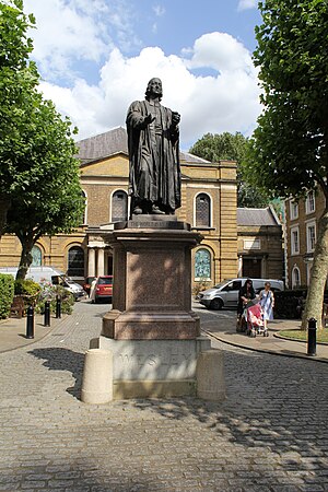
Statue of John Wesley, Shoreditch
Statue in London, United Kingdom
Distance: Approx. 223 meters
Latitude and longitude: 51.52372,-0.08713
A statue of John Wesley, an Anglican minister and theologian, by British sculptor John Adams-Acton is installed outside Wesley's Chapel, along City Road, in Shoreditch, London, United Kingdom. The statue, created in 1891, is Grade II-listed. The 10 foot high granite pedestal on which the statue is located was the work of the Methodist architect Elijah Hoole.

The Foundery
Distance: Approx. 107 meters
Latitude and longitude: 51.5223,-0.0864
The Foundery (or Foundry), in Moorfields, was the first London foundry for casting brass cannon for the British Board of Ordnance. The building subsequently served as the first Wesleyan Methodist house of worship, and an important meeting place for the early Methodist community. In 1778, the Methodist congregation was moved to the nearby purpose-built Wesley's Chapel on City Road.
Weather in this IP's area
broken clouds
14 Celsius
14 Celsius
13 Celsius
15 Celsius
1004 hPa
93 %
1004 hPa
1001 hPa
10000 meters
2.06 m/s
90 degree
75 %
06:24:42
19:31:30