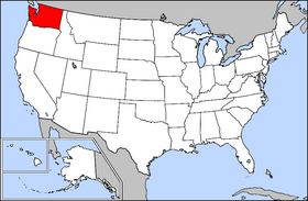
Country:
 USA
USARegion:
City:
Latitude and Longitude:
Time Zone:
Postal Code:
IP information under different IP Channel
ip-api
Country
Region
City
ASN
Time Zone
ISP
Blacklist
Proxy
Latitude
Longitude
Postal
Route
IPinfo
Country
Region
City
ASN
Time Zone
ISP
Blacklist
Proxy
Latitude
Longitude
Postal
Route
MaxMind
Country
Region
City
ASN
Time Zone
ISP
Blacklist
Proxy
Latitude
Longitude
Postal
Route
Luminati
Country
USRegion
wa
City
bonneylake
ASN
Time Zone
America/Los_Angeles
ISP
BLUE-01
Latitude
Longitude
Postal
db-ip
Country
Region
City
ASN
Time Zone
ISP
Blacklist
Proxy
Latitude
Longitude
Postal
Route
ipdata
Country
Region
City
ASN
Time Zone
ISP
Blacklist
Proxy
Latitude
Longitude
Postal
Route
Popular places and events near this IP address

Bryn Mawr-Skyway, Washington
Census-designated place in Washington, United States
Distance: Approx. 1960 meters
Latitude and longitude: 47.49444444,-122.23666667
Bryn Mawr-Skyway (pronounced from Welsh for "big hill") is a census-designated place (CDP) in King County, Washington, United States. The population was 17,397 at the 2020 census. Bryn Mawr-Skyway was the only CDP in the Seattle metropolitan area to have reported a majority-minority population in the 2000 census.
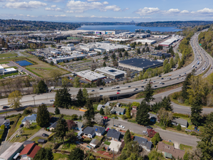
Renton, Washington
City in Washington, United States
Distance: Approx. 1687 meters
Latitude and longitude: 47.48666667,-122.19527778
Renton is a city in King County, Washington, United States, and an inner-ring suburb of Seattle. Situated 11 miles (18 km) southeast of downtown Seattle, Renton straddles the southeast shore of Lake Washington, at the mouth of the Cedar River. As of the 2020 census, the population of Renton was 106,785, up from 90,927 at the 2010 census.
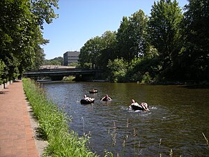
Cedar River (Washington)
River in the United States of America
Distance: Approx. 1967 meters
Latitude and longitude: 47.50055556,-122.21611111
The Cedar River is a river in the U.S. state of Washington. About 45 miles (72 km) long, it originates in the Cascade Range and flows generally west and northwest, emptying into the southern end of Lake Washington. Its upper watershed is a protected area called the Cedar River Watershed, which provides drinking water for the greater Seattle area.

Will Rogers–Wiley Post Memorial Seaplane Base
Seaplane base in King County, Washington, U.S.
Distance: Approx. 1961 meters
Latitude and longitude: 47.500508,-122.21768083
The Will Rogers–Wiley Post Memorial Seaplane Base (FAA LID: W36) is a seaplane base in Washington state. It is owned and operated by the city of Renton and located on Lake Washington at the northwest corner of Renton Municipal Airport, inside the latter's perimeter fence. The base was named after actor Will Rogers and aviator Wiley Post who took off from the water landing at the beginning of a trip to Alaska, during which they were ultimately killed in an air crash.
Washington Interscholastic Activities Association
Distance: Approx. 1116 meters
Latitude and longitude: 47.477,-122.205
The Washington Interscholastic Activities Association (WIAA) is the governing body of athletics and activities for secondary education schools in the state of Washington. As of October 2024, the private, 501(c)(3) nonprofit organization consists of nearly 800 member high schools and middle/junior high schools, both public and private.

Cedar River Trail
Hiking trail
Distance: Approx. 1380 meters
Latitude and longitude: 47.480257,-122.19908
The Cedar River Regional Trail is a partially paved 17.3-mile (27.8 km) rail trail in Washington. The Cedar River Trail was the former mainline of the Milwaukee Road. It is open for non-motorized use and parallels State Route 169 for much of its length.
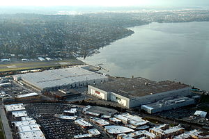
Boeing Renton Factory
Airplane assembly facility in Renton, Washington
Distance: Approx. 1929 meters
Latitude and longitude: 47.49934,-122.2089
The Boeing Renton Factory is the Boeing Company's manufacturing facility for narrow-body commercial airliners, and their military derivatives. Production includes the Boeing 737 MAX passenger airliner and the Boeing P-8 Poseidon military patrol aircraft. The factory covers 1,100,000 square feet (100,000 m2) of floor space.
Renton High School
Free public school in Renton, Washington, United States
Distance: Approx. 401 meters
Latitude and longitude: 47.48277778,-122.21166667
Renton High School is a public secondary school (grades 9–12) in downtown Renton, Washington, U.S., about 10 miles southeast of downtown Seattle. Founded in 1911, it is the oldest high school in the Renton School District.

Renton History Museum
Distance: Approx. 1070 meters
Latitude and longitude: 47.4801,-122.2034
The Renton History Museum is a repository for objects and archives significant to the city of Renton in the state of Washington, United States. The museum has objects and archives of Renton's history and has exhibits and public programs for the community and visitors. It is a joint initiative between the city of Renton and the Renton Historical Society, a non-profit organization providing private sector support for the museum.
Renton School District
Public school district headquartered in Renton, Washington, USA
Distance: Approx. 1008 meters
Latitude and longitude: 47.47416667,-122.22055556
Renton School District 403 is a public school district headquartered in Renton, Washington, USA. The district boundaries include the vast majority of Renton, all of Bryn Mawr-Skyway, and portions of the adjacent cities and communities of Bellevue, East Renton Highlands, Fairwood, Kent, Newcastle, SeaTac, and Tukwila. On October 1 of the 2017-2018 school year, the district has an enrollment of 16,336 students.

Renton Public Library
Distance: Approx. 1133 meters
Latitude and longitude: 47.482,-122.202
The Renton Public Library is the King County Library System (KCLS) branch library in Renton, Washington, in the United States. It was a city library between its construction in 1966 and 2010, when it was one of the last three non-KCLS members in the county outside of Seattle and it was incorporated into KCLS after what may have been "the most contentious annexation fight in the system's 71 years".
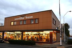
F. W. Woolworth Company Store (Renton, Washington)
United States historic place
Distance: Approx. 825 meters
Latitude and longitude: 47.47985833,-122.20700278
The F. W. Woolworth Company Store Renton is a commercial building in Renton, Washington. Built in 1954, it was listed in the National Register of Historic Places in 2015 for its direct association with growth and development of downtown Renton, and for its connection to the national five-and dime chain store, F.W. Woolworth Company. The building is now a Western Wear store.
Weather in this IP's area
overcast clouds
11 Celsius
10 Celsius
9 Celsius
12 Celsius
1022 hPa
81 %
1022 hPa
1021 hPa
10000 meters
4.12 m/s
150 degree
100 %
07:32:31
18:14:56