Country:
 Netherlands
Region:
City:
Latitude and Longitude:
Time Zone:
Postal Code:
IP information under different IP Channel
ip-api
Country
Region
City
ASN
Time Zone
ISP
Blacklist
Proxy
Latitude
Longitude
Postal
Route
IPinfo
Country
Region
City
ASN
Time Zone
ISP
Blacklist
Proxy
Latitude
Longitude
Postal
Route
MaxMind
Country
Region
City
ASN
Time Zone
ISP
Blacklist
Proxy
Latitude
Longitude
Postal
Route
Luminati
Country
NLASN
Time Zone
Europe/Amsterdam
ISP
SURF B.V.
Latitude
Longitude
Postal
db-ip
Country
Region
City
ASN
Time Zone
ISP
Blacklist
Proxy
Latitude
Longitude
Postal
Route
ipdata
Country
Region
City
ASN
Time Zone
ISP
Blacklist
Proxy
Latitude
Longitude
Postal
Route
Popular places and events near this IP address
Centrum Wiskunde & Informatica
Dutch research institute
Distance: Approx. 208 meters
Latitude and longitude: 52.35638889,4.95194444
The Centrum Wiskunde & Informatica (abbr. CWI; English: "National Research Institute for Mathematics and Computer Science") is a research centre in the field of mathematics and theoretical computer science. It is part of the institutes organization of the Dutch Research Council (NWO) and is located at the Amsterdam Science Park.
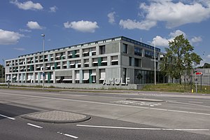
AMOLF
Dutch research institute
Distance: Approx. 248 meters
Latitude and longitude: 52.35527778,4.95194444
AMOLF is a research institute and part of the institutes organization of the Dutch Research Council (NWO). AMOLF carries out fundamental research on the physics and design principles of natural and man-made complex matter. AMOLF uses these insights to create novel functional materials and find new solutions to societal challenges in renewable energy, green ICT and healthcare.

Jaap Edenbaan
Sports park
Distance: Approx. 929 meters
Latitude and longitude: 52.34861111,4.94444444
The Jaap Edenbaan (translated: Jaap Eden track) is an ice rink located in the Watergraafsmeer, a neighborhood of eastern Amsterdam. The rink is named after the famous Dutch ice skater Jaap Eden. It contains a 400-meter lane and Jaap Edenhal.

Amsterdam Science Park
Science park in Amsterdam, Netherlands
Distance: Approx. 285 meters
Latitude and longitude: 52.356,4.953
Amsterdam Science Park is a science park in the Oost borough of Amsterdam, Netherlands with foci on physics, mathematics, information technology and the life sciences. The 70 hectare (175 acre) park provides accommodations for science, business and housing. Resident groups include institutes of the natural science faculties of the University of Amsterdam, several research institutes, and related companies.
Amsterdam University College
Educational institution in the Netherlands
Distance: Approx. 233 meters
Latitude and longitude: 52.3554,4.9518
Amsterdam University College (AUC) is a public liberal arts college in the Netherlands with an enrollment of about 900 students from more than 60 countries. All teaching is in English. The college was founded in 2009 as a joint initiative of the University of Amsterdam and the VU Amsterdam with a particular focus on the natural sciences.
Amsterdam Science Park railway station
Railway station in Amsterdam, Netherlands
Distance: Approx. 446 meters
Latitude and longitude: 52.3525,4.94861111
Amsterdam Science Park is a railway station in the borough Amsterdam-Oost in Amsterdam, Netherlands. The station lies on the Amsterdam–Zutphen railway between the railway stations Amsterdam Muiderpoort and Diemen. The station serves the Science Park Amsterdam and the Watergraafsmeer, as well as Amsterdam University College and the Science Park campus of the University of Amsterdam.

Flevopark
Distance: Approx. 514 meters
Latitude and longitude: 52.36111111,4.94916667
Flevopark is a park located in the Indische Buurt, in the eastern portion of the city of Amsterdam, in the province of North Holland, Netherlands. The park contains a playground, tennis courts, the youth centre "Jeugdland", an outdoor swimming pool, large lawns, barbecue areas, a terrace and several trails for running. On the banks of the Nieuwe Diep is a distillery and tasting room.
Jaap Edenhal
Indoor Ice Rink
Distance: Approx. 799 meters
Latitude and longitude: 52.349916,4.944223
Jaap Edenhal (sometimes anglicized as Jaap Eden Hall) is a 4,500-capacity indoor ice rink located adjacent to Jaap Eden baan in Amsterdam, Netherlands. It is named after Dutch speed skater Jaap Eden. The Amsterdam Tigers are its primary tenant.

Het Houten Stadion
Distance: Approx. 971 meters
Latitude and longitude: 52.34989011,4.93956811
Het Houten Stadion (English: The Wooden Stadium) is a former stadium of AFC Ajax which served as the team's home stadium from 1907 to 1934.
Real Sranang
Dutch football club
Distance: Approx. 838 meters
Latitude and longitude: 52.34916667,4.94611111
Real Sranang (English: Royal Suriname) is an amateur association football club from Amsterdam, Netherlands, founded on 1 June 1960, that plays its home games at the Sportpark Middenmeer.

Nikhef
Distance: Approx. 168 meters
Latitude and longitude: 52.35583333,4.95111111
Nikhef is the Dutch National Institute for Subatomic Physics that performs research in particle physics and astroparticle physics. Amongst others, it is a research partner of the CERN institute in Switzerland and a member of the European Gravitational Observatory. Nikhef is a collaboration between the Dutch Research Council (NWO), University of Amsterdam, Vrije Universiteit Amsterdam, Radboud University, University of Groningen, Maastricht University and Utrecht University.
Valreep
Distance: Approx. 905 meters
Latitude and longitude: 52.3576,4.9357
Op de Valreep was a squatted building in Amsterdam, the Netherlands. Occupied in 2011, the former animal shelter was converted into a self-managed social centre. The squatters resisted eviction with creative actions, such as pretending the council had given them ownership and making spoof election materials.
Weather in this IP's area
broken clouds
14 Celsius
14 Celsius
13 Celsius
15 Celsius
1012 hPa
89 %
1012 hPa
1012 hPa
10000 meters
1.03 m/s
270 degree
75 %
08:12:51
18:37:03