Country:
 Netherlands
Region:
City:
Latitude and Longitude:
Time Zone:
Postal Code:
IP information under different IP Channel
ip-api
Country
Region
City
ASN
Time Zone
ISP
Blacklist
Proxy
Latitude
Longitude
Postal
Route
IPinfo
Country
Region
City
ASN
Time Zone
ISP
Blacklist
Proxy
Latitude
Longitude
Postal
Route
MaxMind
Country
Region
City
ASN
Time Zone
ISP
Blacklist
Proxy
Latitude
Longitude
Postal
Route
Luminati
Country
NLASN
Time Zone
Europe/Amsterdam
ISP
SURF B.V.
Latitude
Longitude
Postal
db-ip
Country
Region
City
ASN
Time Zone
ISP
Blacklist
Proxy
Latitude
Longitude
Postal
Route
ipdata
Country
Region
City
ASN
Time Zone
ISP
Blacklist
Proxy
Latitude
Longitude
Postal
Route
Popular places and events near this IP address

Vredenburg Castle
Distance: Approx. 380 meters
Latitude and longitude: 52.0925,5.11388889
Vredenburg Castle (Dutch: (Kasteel) Vredenburg or Vredeborch) was a 16th-century castle built by Habsburg emperor Charles V in the city of Utrecht in the Netherlands. Some remains of the castle, which stood for only 50 years, are still visible on what is now Vredenburg square in Utrecht.

Utrecht Centraal station
Railway station in the Netherlands
Distance: Approx. 256 meters
Latitude and longitude: 52.08916667,5.10972222
Utrecht Centraal, officially Station Utrecht Centraal (Dutch: [staːˈɕɔn ˈytrɛxt sɛnˈtraːl]), is the transit hub that integrates three bicycle parkings, two bus stations, two tram stops and the central railway station for Utrecht, Netherlands. It is the biggest train station in the Netherlands. Both the railway station and the bus station are the largest and busiest in the Netherlands.
Catharijne
Distance: Approx. 141 meters
Latitude and longitude: 52.08972222,5.11166667
Catharijne is a former municipality on the west side of the Dutch city of Utrecht. It was a separate municipality between 1818 and 1823, when it merged with the city of Utrecht. It was named for the St.

TivoliVredenburg
Distance: Approx. 348 meters
Latitude and longitude: 52.09222222,5.11333333
The TivoliVredenburg is a contemporary music complex located in Utrecht, Netherlands. The venue consists of five halls designed acoustically for a specific music genre. Along with its hall, the venue also features an "amateur stage" and a cafe.

Utrechts Conservatorium
Music school in Utrecht, Netherlands
Distance: Approx. 263 meters
Latitude and longitude: 52.0893,5.1173
The Utrechts Conservatorium is a Conservatory of Music in Utrecht, Netherlands and part of the Utrecht School of the Arts (HKU). The conservatory opened in 1875 and is one of the eldest professional musical education institutes of the Netherlands. Since 1971, the conservatory is located in the former concert hall Gebouw voor Kunsten en Wetenschappen (Building for Arts and Science) and in the former hospital St.

St. Gertrude's Cathedral
Church in Netherlands
Distance: Approx. 220 meters
Latitude and longitude: 52.08888889,5.11666667
St. Gertrude's Cathedral (Dutch: Sint-Gertrudiskathedraal) in Utrecht, the Netherlands, is the seat of the Archbishop of Utrecht and the mother church of the Old Catholic Church of the Netherlands (and of the wider Old Catholic Communion). It is located at Willemsplantsoen, at the edge of the city centre.
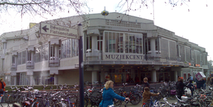
Muziekcentrum Vredenburg
Distance: Approx. 348 meters
Latitude and longitude: 52.09222222,5.11333333
Muziekcentrum Vredenburg was a music venue in Utrecht, Netherlands with a capacity of 5,000 people. It was designed by Dutch architect Herman Hertzberger. The venue hosted concerts by many famous artists, spanning many different genres.

Restaurant Karel 5
Restaurant in Utrecht, Netherlands
Distance: Approx. 363 meters
Latitude and longitude: 52.08787222,5.11838889
Restaurant Karel 5 (formerly known as Grand Restaurant Karel V) was a restaurant, located in the Grand Hotel Karel V in Utrecht, Netherlands. It is a fine dining restaurant that was awarded one Michelin star in the period 2005–2013. In 2013, GaultMillau awarded the restaurant 14 out of 20 points.

Duitse Huis
Historic site in Utrecht, Netherlands
Distance: Approx. 366 meters
Latitude and longitude: 52.087972,5.118495
The Duitse Huis (English: Teutonic House) is a complex of buildings in the city of Utrecht, Netherlands, protected as a national monument. The older parts date to a monastery of the Bailiwick of Utrecht of the Teutonic Knights founded in 1348. Originally Catholic, the order became Protestant during the Reformation.
Grand Hotel Karel V
Distance: Approx. 363 meters
Latitude and longitude: 52.087872,5.118389
The Grand Hotel Karel V is a hotel in Utrecht, Netherlands. It is located in the Duitse Huis complex of buildings, including part of the old monastery of the Bailiwick of Utrecht of the Teutonic Knights founded in 1348. Most of the rooms and suites are in a former military hospital, which dates from 1823 and has been carefully renovated, or in the modern Roman wing opened in 2008.
Old Catholic Archdiocese of Utrecht
Archdiocese within the Old Catholic Church of the Netherlands
Distance: Approx. 222 meters
Latitude and longitude: 52.0889,5.1167
The Old Catholic Archdiocese of Utrecht is an archdiocese within the Old Catholic Church of the Netherlands which split from the Archdiocese of Utrecht officially in 1723 because of the illicit consecration of Cornelius van Steenoven to the episcopate. The first Old Catholic archbishop of Utrecht was elected in 1723. The Old Catholic archbishop of Utrecht is automatically the president of the International Old Catholic Bishops' Conference of the Union of Utrecht.
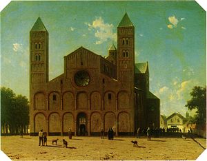
St. Mary's Church, Utrecht
Church in Netherlands
Distance: Approx. 219 meters
Latitude and longitude: 52.08916667,5.11666667
St. Mary's Church, also called Mariakerk or Maria Maior, was one of five collegiate churches in the Dutch city of Utrecht, the others being St. Martin's Cathedral, St.
Weather in this IP's area
moderate rain
14 Celsius
14 Celsius
13 Celsius
15 Celsius
1013 hPa
94 %
1013 hPa
1012 hPa
10000 meters
2.11 m/s
3.47 m/s
259 degree
53 %
08:11:42
18:36:53