192.159.213.176 - IP Lookup: Free IP Address Lookup, Postal Code Lookup, IP Location Lookup, IP ASN, Public IP
Country:
 USA
USARegion:
City:
Location:
Time Zone:
Postal Code:
ISP:
ASN:
language:
User-Agent:
Proxy IP:
Blacklist:
IP information under different IP Channel
ip-api
Country
Region
City
ASN
Time Zone
ISP
Blacklist
Proxy
Latitude
Longitude
Postal
Route
db-ip
Country
Region
City
ASN
Time Zone
ISP
Blacklist
Proxy
Latitude
Longitude
Postal
Route
IPinfo
Country
Region
City
ASN
Time Zone
ISP
Blacklist
Proxy
Latitude
Longitude
Postal
Route
IP2Location
192.159.213.176Country
usRegion
south carolina
City
rock hill
Time Zone
America/New_York
ISP
Language
User-Agent
Latitude
Longitude
Postal
ipdata
Country
Region
City
ASN
Time Zone
ISP
Blacklist
Proxy
Latitude
Longitude
Postal
Route
Popular places and events near this IP address

First Presbyterian Church (Rock Hill, South Carolina)
Historic church in South Carolina, United States
Distance: Approx. 144 meters
Latitude and longitude: 34.92361111,-81.02527778
First Presbyterian Church is a historic church at 234 E. Main Street in Rock Hill, South Carolina. It was designed by Charles Coker Wilson and was built in 1894. It was added to the National Register in 1992.
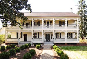
White House (Rock Hill, South Carolina)
Historic house in South Carolina, United States
Distance: Approx. 330 meters
Latitude and longitude: 34.92583333,-81.02166667
The White Home in Rock Hill, South Carolina is a historical site & wedding venue. Five generations of the White family lived in the house between 1837 and 2005. Over the years, the home transformed from a one-room cottage into an eighteen-room, two story house.

United States Post Office and Courthouse (Rock Hill, South Carolina)
United States historic place
Distance: Approx. 68 meters
Latitude and longitude: 34.925,-81.02583333
The U.S. Post Office and Courthouse in Rock Hill, South Carolina, currently known as the Tom S. Gettys Center, was built in 1931-1932. It served historically as a courthouse and as a post office, and is currently in use as a community arts center. The building was listed on the National Register of Historic Places in 1988.

Rock Hill Downtown Historic District
Historic church in South Carolina, United States
Distance: Approx. 43 meters
Latitude and longitude: 34.92527778,-81.025
Rock Hill Downtown Historic District consists of twelve contiguous buildings built between 1870 and 1931 in downtown Rock Hill in York County, South Carolina. The twelve buildings are: Episcopal Church of Our Saviour, 144 Caldwell St. First Associate Reformed Presbyterian Church, 201 E. White St.

Anderson House (Rock Hill, South Carolina)
Historic house in South Carolina, United States
Distance: Approx. 759 meters
Latitude and longitude: 34.93166667,-81.02611111
Anderson House is the former residence of John Gary Anderson, who was president of the Anderson Motor Company in Rock Hill, South Carolina. It was listed on the National Register of Historic Places in 1982.
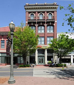
People's National Bank Building (Rock Hill, South Carolina)
United States historic place
Distance: Approx. 183 meters
Latitude and longitude: 34.92555556,-81.02694444
People's National Bank Building, also known as Franklin's Clothing Store, is a historic bank building located at Rock Hill, South Carolina. It was built about 1909–1910, and is a four-story brick building, plus basement. It was the first building in the city constructed as a speculative office building, the first with a passenger elevator, and the tallest commercial building in Rock Hill.

Rock Hill Cotton Factory
United States historic place
Distance: Approx. 441 meters
Latitude and longitude: 34.92833333,-81.0275
Rock Hill Cotton Factory, also known as Plej's Textile Mill Outlets, Ostrow Textile Mill, and Fewell Cotton Warehouse, is a historic textile mill complex located at Rock Hill, South Carolina. The mill was built in 1881, and is a two-story, 12 bay by 16 bay, brick factory. It features a three-story tower at the main entrance.

Marion Street Area Historic District
Historic district in South Carolina, United States
Distance: Approx. 606 meters
Latitude and longitude: 34.92027778,-81.02861111
Marion Street Area Historic District is a national historic district in Rock Hill, South Carolina. It encompasses 28 contributing buildings and 1 contributing site in a middle-class residential section of Rock Hill. The bulk of the district developed between 1906 and 1925.

Reid Street–North Confederate Avenue Area Historic District
Historic district in South Carolina, United States
Distance: Approx. 309 meters
Latitude and longitude: 34.92388889,-81.02194444
Reid Street–North Confederate Avenue Area Historic District is a national historic district located at Rock Hill, South Carolina. It encompasses 22 contributing buildings in a middle-class residential section of Rock Hill. The district developed between about 1839 and 1935.

Rock Hill Printing and Finishing Company
United States historic place
Distance: Approx. 812 meters
Latitude and longitude: 34.93083333,-81.03027778
The Rock Hill Printing and Finish Company, also known locally as The Bleachery is a historic textile processing facility at 400 West White Street in downtown Rock Hill, South Carolina. The complex consists of six buildings dating as far back as 1925, as well as a reservoir, and employed nearly 5,000 workers at its height in 1965. The complex was listed on the National Register of Historic Places in 2008.

Friendship College
Distance: Approx. 784 meters
Latitude and longitude: 34.92797,-81.03283
Friendship College was a private Baptist historically black college, established in 1891, and located in Rock Hill, South Carolina. The school was closed permanently in 1981, and demolished after a fire. The founding president of Friendship College was Rev.
Town Center Mall (Rock Hill)
Shopping mall
Distance: Approx. 227 meters
Latitude and longitude: 34.92581,-81.02732
Town Center Mall was an enclosed shopping mall located in downtown Rock Hill, South Carolina. It opened in 1975. The mall was created by building a roof over several blocks of downtown Rock Hill's Main Street, extending from Hampton Street on the eastern end, to Dave Lyle Boulevard on the west.
Weather in this IP's area
overcast clouds
4 Celsius
2 Celsius
3 Celsius
4 Celsius
1028 hPa
69 %
1028 hPa
1005 hPa
10000 meters
2.06 m/s
100 %