192.151.134.48 - IP Lookup: Free IP Address Lookup, Postal Code Lookup, IP Location Lookup, IP ASN, Public IP
Country:
 Canada
Region:
City:
Location:
Time Zone:
Postal Code:
ISP:
ASN:
language:
User-Agent:
Proxy IP:
Blacklist:
IP information under different IP Channel
ip-api
Country
Region
City
ASN
Time Zone
ISP
Blacklist
Proxy
Latitude
Longitude
Postal
Route
db-ip
Country
Region
City
ASN
Time Zone
ISP
Blacklist
Proxy
Latitude
Longitude
Postal
Route
IPinfo
Country
Region
City
ASN
Time Zone
ISP
Blacklist
Proxy
Latitude
Longitude
Postal
Route
IP2Location
192.151.134.48Country
caRegion
ontario
City
mississauga
Time Zone
America/Toronto
ISP
Language
User-Agent
Latitude
Longitude
Postal
ipdata
Country
Region
City
ASN
Time Zone
ISP
Blacklist
Proxy
Latitude
Longitude
Postal
Route
Popular places and events near this IP address

Mississauga—Erindale
Former federal electoral district in Ontario, Canada
Distance: Approx. 3175 meters
Latitude and longitude: 43.5,-79.7
Mississauga—Erindale was a federal electoral district in Ontario, Canada, that was represented in the House of Commons of Canada from 2004 to 2015. It was created in 2003 from parts of Mississauga Centre and Mississauga West ridings. In 2013, it was abolished into Mississauga—Erin Mills, Mississauga Centre and Mississauga—Lakeshore.

Loyola Catholic Secondary School
Catholic high school in Mississauga, Ontario, Canada
Distance: Approx. 119 meters
Latitude and longitude: 43.5261,-79.7129
Loyola Catholic Secondary School is a Roman Catholic high school located in Mississauga, Ontario, Canada. The school has approximately 1500 students, and is operated by the Dufferin-Peel Catholic District School Board. Every two years, Loyola hosts "Culturefest", a celebration of Canada's diverse cultural make-up that features pavilions, food, and entertainment.
Erin Mills
Suburban district in Peel, Ontario, Canada
Distance: Approx. 2424 meters
Latitude and longitude: 43.54777778,-79.70722222
Erin Mills is a large suburban district in the city of Mississauga, Ontario, Canada, approximately 32 km (20 mi) west of Downtown Toronto. Starting in the 1970s, Erin Mills was developed as a "new town" by the Cadillac Fairview Corporation on over 7,000 acres (28 km2) of farmland around Erin Mills Town Centre. Cadillac Fairview inherited the development from E. P. Taylor's Don Mills Development Corporation, which acquired land in the 1950s and coined the area's name.

St. Aloysius Gonzaga Secondary School
Catholic high school in Mississauga, Ontario, Canada
Distance: Approx. 3340 meters
Latitude and longitude: 43.5565,-79.7176
St. Aloysius Gonzaga Secondary School is a Catholic high school located in the Erin Mills community of Mississauga, Ontario, named after Saint Aloysius Gonzaga. The school opened in Mississauga in 2001, after spending a year as a holding school in Georgetown.

The Meeting House
Church in Ontario, Canada
Distance: Approx. 2908 meters
Latitude and longitude: 43.5112,-79.6851
The Meeting House was an Anabaptist church located in the Greater Toronto Area suburb of Oakville, Ontario. A member of the Be in Christ Church of Canada, the Canadian branch of the Brethren in Christ Church, at its height it consisted of nineteen regional sites that met mostly in cinemas, each of which had a lead pastor with a team of elders and part-time staff. It was started in 1985 by Craig and Laura Sider and a board of overseers.

South Common Centre Bus Terminal
Distance: Approx. 3075 meters
Latitude and longitude: 43.54333333,-79.68388889
The South Common Centre Bus Terminal is located in western Mississauga, Ontario, Canada. It is situated on the western side of South Common Centre. The terminal does not contain a building, partly due to having direct connection to the mall and to the nearby buildings such as South Common Library.

Archbishop Romero Catholic Secondary School (Mississauga)
School in Mississauga, Ontario, Canada
Distance: Approx. 2762 meters
Latitude and longitude: 43.55111111,-79.70888889
St. Oscar Romero Catholic Secondary School is an alternative-style Separate high school located in Mississauga, Ontario, Canada, with satellite campuses in Brampton and Caledon. The school is administered by the Dufferin-Peel Catholic District School Board.

Mississauga—Erin Mills (federal electoral district)
Federal electoral district in Ontario, Canada
Distance: Approx. 2430 meters
Latitude and longitude: 43.545,-79.698
Mississauga—Erin Mills is a federal electoral district in Ontario. It encompasses a portion of Ontario formerly included in the electoral district of Mississauga—Erindale. Mississauga—Erin Mills was created by the 2012 federal electoral boundaries redistribution and was legally defined in the 2013 representation order.
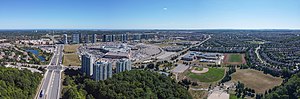
Winston Churchill station
Distance: Approx. 1870 meters
Latitude and longitude: 43.54333333,-79.71222222
Winston Churchill is a bus station in the community of Erin Mills in western Mississauga, Ontario, Canada. It is located northwest of the Winston Churchill Boulevard / Highway 403 interchange and is the western terminus of the Mississauga Transitway. Metrolinx began construction of the Mississauga Transitway West between Winston Churchill Boulevard and Erin Mills Parkway in October 2013 and was completed on December 31, 2016.
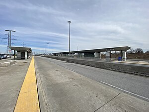
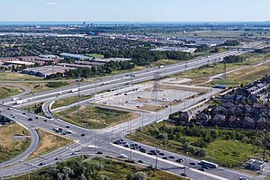
Erin Mills station
Bus station in Mississauga, Ontario
Distance: Approx. 3242 meters
Latitude and longitude: 43.55361111,-79.69916667
Erin Mills is a bus station in the community of Erin Mills in western Mississauga, Ontario, Canada. It is located northwest of the Erin Mills Parkway/Highway 403 interchange and is a stop on the Mississauga Transitway. Metrolinx began construction of the Mississauga Transitway West between Winston Churchill Boulevard and Erin Mills Parkway in October 2013 and the entire project was expected to be complete in 2016.

Churchill Meadows
Neighbourhood in Peel, Ontario, Canada
Distance: Approx. 3028 meters
Latitude and longitude: 43.55,-79.73333333
Churchill Meadows is a suburban residential neighbourhood located in the westernmost area of Mississauga, Ontario, Canada. In 2016, Churchill Meadows had a population of 47,800. Postal codes in this area are L5M. The official neighbourhood boundaries for Churchill Meadows are Highway 407 to the west, Britannia Road to the North, Winston Churchill Boulevard to the east and Highway 403 to the south.

Mississauga—Erin Mills (provincial electoral district)
Provincial electoral district in Ontario, Canada
Distance: Approx. 2430 meters
Latitude and longitude: 43.545,-79.698
Mississauga—Erin Mills is a provincial electoral district in Ontario, Canada. It elects one member to the Legislative Assembly of Ontario. This riding was created in 2015.
Weather in this IP's area
overcast clouds
0 Celsius
-5 Celsius
-0 Celsius
1 Celsius
1005 hPa
81 %
1005 hPa
985 hPa
10000 meters
6.17 m/s
9.77 m/s
240 degree
100 %