Country:
Region:
City:
Latitude and Longitude:
Time Zone:
Postal Code:
IP information under different IP Channel
ip-api
Country
Region
City
ASN
Time Zone
ISP
Blacklist
Proxy
Latitude
Longitude
Postal
Route
Luminati
Country
ASN
Time Zone
America/Chicago
ISP
UPNLLC
Latitude
Longitude
Postal
IPinfo
Country
Region
City
ASN
Time Zone
ISP
Blacklist
Proxy
Latitude
Longitude
Postal
Route
db-ip
Country
Region
City
ASN
Time Zone
ISP
Blacklist
Proxy
Latitude
Longitude
Postal
Route
ipdata
Country
Region
City
ASN
Time Zone
ISP
Blacklist
Proxy
Latitude
Longitude
Postal
Route
Popular places and events near this IP address

Unity Village, Missouri
Village in Missouri, United States
Distance: Approx. 927 meters
Latitude and longitude: 38.94638889,-94.39944444
Unity Village is a village in Jackson County, Missouri, United States, bordering Kansas City and Lee's Summit. It is part of the Kansas City metropolitan area. Its population was 99 at the 2010 census.
Lee's Summit, Missouri
City in Missouri, United States
Distance: Approx. 2934 meters
Latitude and longitude: 38.91722222,-94.38166667
Lee's Summit is a city in the U.S. state of Missouri and is a suburb in the Kansas City metropolitan area. It resides in Jackson County (predominantly) as well as Cass County. As of the 2020 census, its population was 101,108, making it the 6th most populous city in both Missouri and the Kansas City metropolitan area.

Lee's Summit North High School
Public high school in Lee's Summit, Missouri, United States
Distance: Approx. 2346 meters
Latitude and longitude: 38.92907,-94.37765
Lee's Summit North High School is a high school that serves grades 9–12. It is in Lee's Summit, Missouri, United States and is the second of three high schools opened there. The other two schools are Lee's Summit West High School and Lee's Summit High School.
Lee's Summit Historical Cemetery
Cemetery in Lee's Summit, Missouri
Distance: Approx. 4142 meters
Latitude and longitude: 38.91611111,-94.36361111
Lee's Summit Historical Cemetery (LSHC) is a cemetery in Lee's Summit, Missouri.
Vale Tunnel
Distance: Approx. 3073 meters
Latitude and longitude: 38.9477,-94.43537
The Vale Tunnel is a railway tunnel south of Raytown, Missouri in the Kansas City metropolitan area. It was built by the Chicago, Rock Island and Pacific railroad in 1903-1904, and became the final tunnel of four to be built on the entire Rock Island railroad, all of which were in Missouri. The tunnel is part of the Kansas City to St.

Saint Paul's Episcopal Church (Lee's Summit, Missouri)
Historic church in Missouri, United States
Distance: Approx. 3984 meters
Latitude and longitude: 38.91083333,-94.3725
St. Paul's Episcopal Church is a historic Carpenter Gothic style Episcopal church building located on a triangular lot at 416 Southeast Grand Avenue at the corner of Fifth and Green streets in Lee's Summit, Missouri, United States. The parish was established in 1867.
Lee's Summit Municipal Airport
Airport
Distance: Approx. 3565 meters
Latitude and longitude: 38.95972222,-94.37138889
Lee's Summit Municipal Airport (ICAO: KLXT, FAA LID: LXT) is a public use airport in Jackson County, Missouri, United States. It is owned by the City of Lee's Summit and is located three nautical miles (6 km) north of its central business district. This facility is included in the National Plan of Integrated Airport Systems, which categorized it as a general aviation reliever airport.
Summit Woods Crossing
Distance: Approx. 1196 meters
Latitude and longitude: 38.92895,-94.40881
Summit Woods Crossing is an open air shopping center in Lee's Summit, Missouri which is located on US Hwy 50 at I-470. Summit Woods Crossing is across US 50 from Summit Fair. It opened in 2001.

Lee's Summit station
Distance: Approx. 3539 meters
Latitude and longitude: 38.9124,-94.3783
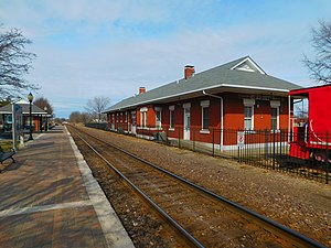
Lee's Summit station is an Amtrak train station in Lee's Summit, Missouri, United States. The station was originally built in 1905 by the Missouri Pacific Railroad. Although the station house remains intact, passengers board the trains from an all-glass rail house across the tracks.
Summit Fair
Shopping mall in Missouri, United States
Distance: Approx. 1196 meters
Latitude and longitude: 38.92895,-94.40881
Summit Fair is a 500,000 square foot open-air lifestyle center that opened in 2009. It is located in Lee's Summit, Missouri. It has approximately 50 shops.
St. Michael the Archangel Catholic High School
Private high school in Lee's Summit, Missouri, United States
Distance: Approx. 3512 meters
Latitude and longitude: 38.9663,-94.3833
St. Michael the Archangel Catholic High School (SMA) is a private, Roman Catholic, co-educational high school in Lee's Summit, Missouri, United States. It was established in 2017 and is part of the Roman Catholic Diocese of Kansas City–St.
Saint Luke's East Hospital
Hospital in Missouri, United States
Distance: Approx. 1778 meters
Latitude and longitude: 38.941761,-94.38195
Saint Luke's East Hospital is a 238-bed hospital located in Lee's Summit, Missouri.
Weather in this IP's area
mist
14 Celsius
14 Celsius
13 Celsius
15 Celsius
1009 hPa
94 %
1009 hPa
975 hPa
9656 meters
2.68 m/s
80 degree
100 %
07:04:25
17:01:42
