192.150.112.117 - IP Lookup: Free IP Address Lookup, Postal Code Lookup, IP Location Lookup, IP ASN, Public IP
Country:
Region:
City:
Location:
Time Zone:
Postal Code:
IP information under different IP Channel
ip-api
Country
Region
City
ASN
Time Zone
ISP
Blacklist
Proxy
Latitude
Longitude
Postal
Route
Luminati
Country
ASN
Time Zone
America/Chicago
ISP
DQECOM
Latitude
Longitude
Postal
IPinfo
Country
Region
City
ASN
Time Zone
ISP
Blacklist
Proxy
Latitude
Longitude
Postal
Route
IP2Location
192.150.112.117Country
Region
pennsylvania
City
aliquippa
Time Zone
America/New_York
ISP
Language
User-Agent
Latitude
Longitude
Postal
db-ip
Country
Region
City
ASN
Time Zone
ISP
Blacklist
Proxy
Latitude
Longitude
Postal
Route
ipdata
Country
Region
City
ASN
Time Zone
ISP
Blacklist
Proxy
Latitude
Longitude
Postal
Route
Popular places and events near this IP address

Aliquippa, Pennsylvania
City in Pennsylvania, United States
Distance: Approx. 2065 meters
Latitude and longitude: 40.615,-80.26305556
Aliquippa is a city in Beaver County, Pennsylvania, United States, along the Ohio River. The population was 9,238 at the 2020 census. It is located 18 miles (29 km) northwest of Pittsburgh and is part of the Pittsburgh metropolitan area.

Center Township, Beaver County, Pennsylvania
Township in Pennsylvania, United States
Distance: Approx. 1724 meters
Latitude and longitude: 40.61666667,-80.29861111
Center Township is a township in Beaver County, Pennsylvania, United States. As of the 2020 census, it had a population of 11,649. It is a suburban community located approximately 25 miles (40 km) northwest of Pittsburgh.

Hopewell Township, Beaver County, Pennsylvania
Township in Pennsylvania, United States
Distance: Approx. 4285 meters
Latitude and longitude: 40.63333333,-80.24888889
Hopewell Township is a township in Beaver County, Pennsylvania, United States. The population was 13,506 at the 2020 census. A suburb of Pittsburgh, it is part of the Pittsburgh metropolitan area.

Ambridge–Aliquippa Bridge
Bridge which crosses the Ohio River at Ambridge, Pennsylvania
Distance: Approx. 4291 meters
Latitude and longitude: 40.5923,-80.2366
The Ambridge–Aliquippa Bridge is a steel cantilever through truss bridge which crosses the Ohio River at Ambridge, Pennsylvania. The bridge was originally named the Ambridge-Woodlawn Bridge but was soon renamed Ambridge-Aliquippa when Woodlawn was eclipsed by the rapid expansion of the Aliquippa Works of the Jones & Laughlin Steel Company. Ambridge was incorporated in 1910 - named after the American Bridge Company which had significant operations along the Ohio River opposite the Jones & Laughlin Steel Company.
Aliquippa Junior/Senior High School
Public, coeducational high school in Aliquippa, Pennsylvania, United States
Distance: Approx. 2255 meters
Latitude and longitude: 40.6114,-80.2586
Aliquippa Junior/Senior High School is a public high school in Aliquippa, Pennsylvania. It is the only high school in the Aliquippa School District. Athletic teams compete as the Aliquippa Quips in the Western Pennsylvania Interscholastic Athletic League (WPIAL).
Hopewell High School (Pennsylvania)
Secondary school in Aliquippa, Beaver County, Pennsylvania, United States
Distance: Approx. 3292 meters
Latitude and longitude: 40.588,-80.253
Hopewell High School is a public high school in Hopewell Township, Pennsylvania, United States. It is the only high school in the Hopewell Area School District. Athletic teams compete as the Hopewell Vikings in the Western Pennsylvania Interscholastic Athletic League.
West Aliquippa, Pennsylvania
Village in Pennsylvania, U.S.
Distance: Approx. 3515 meters
Latitude and longitude: 40.591,-80.321
West Aliquippa is a village located on the Ohio River near Aliquippa, Pennsylvania, United States. It is only one of two villages (the other being Fombell) in Beaver County, Pennsylvania. The community is located just north of the city of Aliquippa, from which it derives its name.
Aliquippa station
Historic railway station, Pennsylvania, U. S.
Distance: Approx. 3790 meters
Latitude and longitude: 40.61886111,-80.24283333
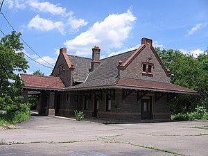
Aliquippa station is a former railway station located in Aliquippa, Pennsylvania, United States. The station was constructed and used by the now defunct Pittsburgh and Lake Erie Railroad (P&LE). Constructed in 1911, the station has also gone by the name of Woodlawn station because of the former town of Woodlawn that was merged with Aliquippa in the late 1870s.

Aliquippa School District
School district in Pennsylvania
Distance: Approx. 2154 meters
Latitude and longitude: 40.610651,-80.259565
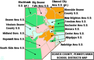
The Aliquippa School District is a small, urban, public school district located in Beaver County, Pennsylvania. The District serves the City of Aliquippa. Aliquippa School District encompasses approximately 4 square miles (10 km2).

USAir Flight 427
Aviation accident in 1994
Distance: Approx. 2211 meters
Latitude and longitude: 40.60393,-80.31026
USAir Flight 427 was a scheduled flight from Chicago's O'Hare International Airport to Palm Beach International Airport, Florida, with a stopover at Pittsburgh International Airport. On Thursday, September 8, 1994, the Boeing 737 flying this route crashed in Hopewell Township, Pennsylvania while approaching Runway 28R at Pittsburgh, which was USAir's largest hub at the time. This accident was the second longest air crash investigation in history.

B.F. Jones Memorial Library
United States historic place
Distance: Approx. 2891 meters
Latitude and longitude: 40.61305556,-80.25138889
The B.F. Jones Memorial Library is a historic library in Aliquippa, a city in Beaver County, Pennsylvania, United States. Named for steel tycoon Benjamin Franklin Jones, it was built in 1927 with money donated by Jones' daughter.: 5 As a product of the profits of the Jones and Laughlin Steel Company, for which Aliquippa was a company town, it resembled a Carnegie library. Rated a high-quality example of small-scale Renaissance Revival architecture, the two-story library is built primarily of Indiana Limestone with a bronze roof.: 2, 7 Among its leading features are multiple plaster casts, windows of stained glass, carvings in imitation of those made by Italian sculptor Andrea della Robbia, and a large statue of Jones.: 3, 5 In 1978, the library was added to the National Register of Historic Places for its architecture and for its association with Jones in the development of Aliquippa.: 5 The library continues in operation to the present day.

First Moon Township, Pennsylvania
Distance: Approx. 1612 meters
Latitude and longitude: 40.6,-80.26666667
First Moon Township, in Beaver County, Pennsylvania, existed from 1800 to 1812.
Weather in this IP's area
overcast clouds
-4 Celsius
-11 Celsius
-5 Celsius
-3 Celsius
1025 hPa
68 %
1025 hPa
989 hPa
10000 meters
7.2 m/s
270 degree
100 %
