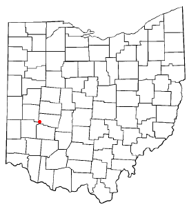
Country:
Region:
City:
Latitude and Longitude:
Time Zone:
Postal Code:
IP information under different IP Channel
ip-api
Country
Region
City
ASN
Time Zone
ISP
Blacklist
Proxy
Latitude
Longitude
Postal
Route
Luminati
Country
Region
mn
ASN
Time Zone
America/Chicago
ISP
CLOUGIX-11775
Latitude
Longitude
Postal
IPinfo
Country
Region
City
ASN
Time Zone
ISP
Blacklist
Proxy
Latitude
Longitude
Postal
Route
db-ip
Country
Region
City
ASN
Time Zone
ISP
Blacklist
Proxy
Latitude
Longitude
Postal
Route
ipdata
Country
Region
City
ASN
Time Zone
ISP
Blacklist
Proxy
Latitude
Longitude
Postal
Route
Popular places and events near this IP address

Crystal Lakes, Ohio
Census-designated place in Ohio, United States
Distance: Approx. 5288 meters
Latitude and longitude: 39.88611111,-84.02416667
Crystal Lakes is a census-designated place (CDP) in Clark County, Ohio, United States. The population was 1,394 at the 2020 census. It is part of the Springfield, Ohio Metropolitan Statistical Area.

New Carlisle, Ohio
City in Ohio, United States
Distance: Approx. 1406 meters
Latitude and longitude: 39.94472222,-84.02555556
New Carlisle ( NEW kar-LY-əl) is a city in Bethel Township, Clark County, Ohio, United States. The population was 5,559 at the 2020 census. It is part of the Springfield, Ohio Metropolitan Statistical Area.

Park Layne, Ohio
Census-designated place in Ohio, United States
Distance: Approx. 5062 meters
Latitude and longitude: 39.88805556,-84.03944444
Park Layne is a census-designated place (CDP) in Bethel Township, Clark County, Ohio, United States. The population of the CDP was 4,248 at the 2020 census. It is part of the Springfield, Ohio Metropolitan Statistical Area.
Medway, Ohio
Unincorporated community in Ohio, United States
Distance: Approx. 6023 meters
Latitude and longitude: 39.88194444,-84.00972222
Medway is an unincorporated community and census-designated place in Bethel Township, Clark County, Ohio, United States. It is part of the Springfield, Ohio Metropolitan Statistical Area. Near are the adjoining communities of Crystal Lakes and Park Layne.

Bethel Township, Miami County, Ohio
Township in Ohio, United States
Distance: Approx. 5293 meters
Latitude and longitude: 39.93,-84.09416667
Bethel Township is one of the twelve townships of Miami County, Ohio, United States. The 2020 census found 4,758 people in the township.
Tecumseh High School (New Carlisle, Ohio)
Public, coeducational high school in New Carlisle, Ohio, United States
Distance: Approx. 3673 meters
Latitude and longitude: 39.9149,-83.9965
Tecumseh High School is a public high school near New Carlisle, Ohio. The school and district are named in honor of Tecumseh, a chief of the Shawnee people who lived in the general area between approximately 1768 and 1813.
Bethel High School (Ohio)
School in Ohio, United States
Distance: Approx. 4849 meters
Latitude and longitude: 39.919,-84.086
Bethel High School is a public high school in Miami County, Ohio. It is the only high school in the Bethel Local School district. The student enrollment is about 345, in grades 9–12.

Bethel Township, Clark County, Ohio
Township in Ohio, United States
Distance: Approx. 3292 meters
Latitude and longitude: 39.90666667,-84.01527778
Bethel Township is one of the ten townships of Clark County, Ohio, United States. The 2020 census reported 18,050 people living in the township.

Olive Branch High School (New Carlisle, Ohio)
Public, coeducational high school in New Carlisle, , Ohio, United States
Distance: Approx. 3813 meters
Latitude and longitude: 39.912713,-83.996505
Olive Branch High School was a public high school near New Carlisle, Ohio.

William Baumgardner Farm
United States historic place
Distance: Approx. 3818 meters
Latitude and longitude: 39.90611111,-84.05972222
The William Baumgardner Farm is a historic farmstead located near New Carlisle in Miami County, Ohio, United States. Constructed in 1857, the site remains typical of period farmsteads, and it has been named a historic site. William Baumgardner was one of Miami County's wealthiest farmers, and his landholdings were among the county's widest.
Dodo, Ohio
Unincorporated community in Ohio, U.S.
Distance: Approx. 6521 meters
Latitude and longitude: 39.98333333,-83.99277778
Dodo is an unincorporated community in Clark County, in the U.S. state of Ohio.
Forgy, Ohio
Unincorporated community in Ohio, U.S.
Distance: Approx. 4131 meters
Latitude and longitude: 39.91305556,-83.99166667
Forgy is an unincorporated community in Clark County, in the U.S. state of Ohio.
Weather in this IP's area
mist
10 Celsius
10 Celsius
9 Celsius
11 Celsius
1015 hPa
94 %
1015 hPa
983 hPa
6437 meters
4.63 m/s
290 degree
100 %
07:21:50
17:20:03