192.146.253.8 - IP Lookup: Free IP Address Lookup, Postal Code Lookup, IP Location Lookup, IP ASN, Public IP
Country:
 Australia
Region:
City:
Location:
Time Zone:
Postal Code:
ISP:
ASN:
language:
User-Agent:
Proxy IP:
Blacklist:
IP information under different IP Channel
ip-api
Country
Region
City
ASN
Time Zone
ISP
Blacklist
Proxy
Latitude
Longitude
Postal
Route
db-ip
Country
Region
City
ASN
Time Zone
ISP
Blacklist
Proxy
Latitude
Longitude
Postal
Route
IPinfo
Country
Region
City
ASN
Time Zone
ISP
Blacklist
Proxy
Latitude
Longitude
Postal
Route
IP2Location
192.146.253.8Country
auRegion
new south wales
City
rhodes
Time Zone
Australia/Sydney
ISP
Language
User-Agent
Latitude
Longitude
Postal
ipdata
Country
Region
City
ASN
Time Zone
ISP
Blacklist
Proxy
Latitude
Longitude
Postal
Route
Popular places and events near this IP address

Rhodes, New South Wales
Suburb of Sydney, New South Wales, Australia
Distance: Approx. 608 meters
Latitude and longitude: -33.82821,151.08569
Rhodes is an Inner West suburb of Sydney, in the state of New South Wales, Australia. Rhodes is located 12 kilometres west of the Sydney central business district, in the local government area of the City of Canada Bay. It was formerly part of Concord Municipality until a merger with Drummoyne Council to form Canada Bay in December 2000.

Homebush Bay
Suburb of Sydney, New South Wales, Australia
Distance: Approx. 559 meters
Latitude and longitude: -33.8287,151.08088
Homebush Bay is a bay on the south bank of the Parramatta River, in the west of Sydney, Australia. The name is also sometimes used to refer to an area to the west and south of the bay itself, which was formerly an official suburb of Sydney, and has now become the suburbs of Sydney Olympic Park, Wentworth Point and part of the neighbouring suburb of Lidcombe, all part of the City of Parramatta. Homebush Bay is located 13 kilometres (8.1 mi) west of the Sydney central business district.

Concord Repatriation General Hospital
Hospital in New South Wales, Australia
Distance: Approx. 1006 meters
Latitude and longitude: -33.83743,151.09298
Concord Repatriation General Hospital (abbreviated CRGH), commonly referred to as Concord Hospital, is a district general hospital in Sydney, Australia, on Hospital Road in Concord. It is a teaching hospital of Sydney Medical School at the University of Sydney, where it is referred to as Concord Clinical School, and a major facility in the Sydney Local Health District and the former Sydney South West Area Health Service. The NSW Statewide Severe Burn Injury Service and the Bernie Banton Centre, an asbestos diseases research institute, are located there.

Rhodes railway station
Railway station in Sydney, New South Wales, Australia
Distance: Approx. 459 meters
Latitude and longitude: -33.830529,151.086983
Rhodes railway station is a heritage-listed railway station located on the Main Northern line, serving the Sydney suburbs of Rhodes and Liberty Grove both in City of Canada Bay, Sydney, New South Wales, Australia. It is served by Sydney Trains' T9 Northern Line services.

Rhodes Waterside
Shopping mall in New South Wales, Australia
Distance: Approx. 273 meters
Latitude and longitude: -33.8353,151.085
Rhodes Waterside (previously known as Rhodes Shopping Centre) is a shopping centre in the suburb of Rhodes in the Inner West of Sydney.

Powells Creek (Sydney)
River in Australia
Distance: Approx. 740 meters
Latitude and longitude: -33.83953183,151.080522
Powells Creek, a southern tributary of the Parramatta River, is an urban stream west of Sydney Harbour, located in Sydney, Australia. It flows through Sydney Olympic Park and joins Parramatta River at Homebush Bay.

Haslams Creek
River in New South Wales, Australia
Distance: Approx. 660 meters
Latitude and longitude: -33.83444983,151.0763
Haslams Creek, a southern tributary of the Parramatta River, is a creek west of Sydney Harbour, located in Sydney, Australia. It flows through Sydney Olympic Park and joins Parramatta River at Homebush Bay. In 1793, the first grants were made to free settlers, with Samuel Haslam receiving his first grant in 1806.

Sydney International Archery Park
Stadium in Sydney, New South Wales, Australia
Distance: Approx. 956 meters
Latitude and longitude: -33.834,151.073
The Sydney International Archery Park is a stadium is located in the Sydney Olympic Park suburb of Sydney, New South Wales, Australia. It was specially designed for archery during the 2000 Summer Olympics. It was designed by Stutchbury and Pape.

Wentworth Point, New South Wales
Suburb of Sydney, New South Wales, Australia
Distance: Approx. 909 meters
Latitude and longitude: -33.82638889,151.07805556
Wentworth Point is a suburb of Sydney, in the state of New South Wales, Australia. It is located 13 kilometres west of the Sydney central business district, on the eastern edge of the local government area of City of Parramatta. It is on the western shore of Homebush Bay on the southern side of the Parramatta River.

Kokoda Track Memorial Walkway
Unique living war memorial in Concord (Sydney) to commemorate the 1942 Kokoda Track campaign
Distance: Approx. 736 meters
Latitude and longitude: -33.834695,151.09108
The Kokoda Track Memorial Walkway is a walking track and war memorial located in the suburb of Concord West, Sydney, New South Wales, Australia. It is located along Brays Bay on the Parramatta River, and is a unique tribute to the Australian troops who fought in the World War II Papua-New Guinea campaign of July 1942 till December 1943. The Walkway serves as a focal point for local, state and national representatives to honour the service of those who fought in Papua New Guinea, and to ensure the service and sacrifices of those individuals (including the Fuzzy Wuzzy Angels and other Papuans who assisted the Australians) is passed on to current and future generations, particularly school children through a comprehensive schools visitation program.

HMAS Karangi
Boom defence vessel of the Royal Australian Navy
Distance: Approx. 426 meters
Latitude and longitude: -33.8363379,151.0804902
HMAS Karangi was a Kangaroo-class boom defence vessel operated by the Royal Australian Navy (RAN) during World War II. The third of three ships constructed by the Cockatoo Docks and Engineering Company at Cockatoo Island Dockyard based on the British Bar-class, Karangi was launched on 16 August 1941. After the war, the ship remained in active service with the RAN and played a small but key role in the British nuclear testing program. She was placed in reserve in 1953.
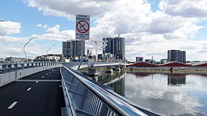
Bennelong Bridge
Bridge in New South Wales, Australia
Distance: Approx. 671 meters
Latitude and longitude: -33.8274,151.0818
The Bennelong Bridge is a 330-metre-long (1,080 ft) vehicular bridge across Homebush Bay between the Sydney suburbs of Rhodes and Wentworth Point. Construction started on 1 September 2014, and it opened on 22 May 2016.
Weather in this IP's area
broken clouds
26 Celsius
26 Celsius
24 Celsius
27 Celsius
1021 hPa
68 %
1021 hPa
1012 hPa
10000 meters
6.69 m/s
130 degree
75 %