Country:
 USA
USARegion:
City:
Latitude and Longitude:
Time Zone:
Postal Code:
IP information under different IP Channel
ip-api
Country
Region
City
ASN
Time Zone
ISP
Blacklist
Proxy
Latitude
Longitude
Postal
Route
IPinfo
Country
Region
City
ASN
Time Zone
ISP
Blacklist
Proxy
Latitude
Longitude
Postal
Route
MaxMind
Country
Region
City
ASN
Time Zone
ISP
Blacklist
Proxy
Latitude
Longitude
Postal
Route
Luminati
Country
USRegion
mi
City
kalamazoo
ASN
Time Zone
America/Detroit
ISP
CTSTELECOM
Latitude
Longitude
Postal
db-ip
Country
Region
City
ASN
Time Zone
ISP
Blacklist
Proxy
Latitude
Longitude
Postal
Route
ipdata
Country
Region
City
ASN
Time Zone
ISP
Blacklist
Proxy
Latitude
Longitude
Postal
Route
Popular places and events near this IP address

Oshtemo Township, Michigan
Charter township in Michigan, United States
Distance: Approx. 835 meters
Latitude and longitude: 42.28333333,-85.68222222
Oshtemo Charter Township is a charter township of Kalamazoo County in the U.S. state of Michigan. The 2020 census recorded a population of 23,747, up from 21,705 at the 2010 census. The township was organized in 1839.
Maple Hill Pavilion
Shopping mall in Michigan, United States
Distance: Approx. 3811 meters
Latitude and longitude: 42.298,-85.652
Maple Hill Pavilion (formerly Maple Hill Mall) is a strip mall serving the city of Kalamazoo, Michigan, United States. Maple Hill Mall became a "dead mall" after several years of decline and the loss of several major tenants. The center has since been redeveloped as a strip mall called Maple Hill Pavilion, which features DSW Shoe Warehouse, Hobby Lobby, Marshalls, PetSmart, Pier One Imports, Office Max, Rooms Today and Target as its anchor stores.

Newman's Airport
Public airpark in Kalamazoo, Michigan
Distance: Approx. 5033 meters
Latitude and longitude: 42.28888889,-85.75
Newman's Airport (FAA LID: 4N0) is a privately owned, public airport located 7 mi (11.3 km) west of Kalamazoo, Michigan, United States. It is a choice for many pilots in the area who wish to avoid the Kalamazoo-Battle Creek International Airport. Newman's is an airpark community consisting of 13 homes each with private hangars.
WZUU
Radio station in Mattawan, Michigan
Distance: Approx. 2729 meters
Latitude and longitude: 42.255,-85.683
WZUU (92.5 FM, "The ZUU [Zoo]") is a radio station broadcasting a mainstream rock format. Licensed to Mattawan, Michigan, it first began broadcasting in 1990 under the WKGH call sign. During the first few years of the radio station, it broadcast oldies from a satellite feed.
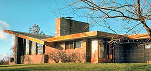
Robert and Rae Levin House
House in Kalamazoo, Michigan
Distance: Approx. 5100 meters
Latitude and longitude: 42.262816,-85.632425
Robert and Rae Levin House, also Robert Levin House and Robert Levin Residence, is a single-family home in Kalamazoo, Michigan and designed by Frank Lloyd Wright. In 1949, Robert and Rae Levin worked with Frank Lloyd Wright to build a house, the first one to be constructed in Parkwyn Village, a planned community of Usonian houses. Usonia is a word used by Frank Lloyd Wright and refers to the residents of the United States Of North America.
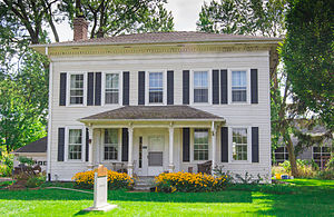
John Gibbs House (Kalamazoo, Michigan)
Historic house in Michigan, United States
Distance: Approx. 4648 meters
Latitude and longitude: 42.25972222,-85.64027778
The John Gibbs House was built in Kalamazoo, Michigan, in 1853. The house is located on the south side of Parkview Avenue next to Western Michigan University's Business Technology and Research Park in Kalamazoo, Michigan. It was listed on the National Register of Historic Places in 1983.
WMU Soccer Complex
Distance: Approx. 4666 meters
Latitude and longitude: 42.25758,-85.64163
The Western Michigan University Soccer Complex is a soccer-specific stadium located in Kalamazoo, Michigan on the campus of Western Michigan University. Originally known as Lee Baker Field, the complex is adjacent to WMU's Business, Technology & Research Park and the Engineering College campus, and is home to both the Western Michigan Broncos men's and women's soccer teams. The stands seat about 500, and there is standing room along the fencelines, particularly on the north and west sides.

Silas W. Kendall House
United States historic place
Distance: Approx. 2699 meters
Latitude and longitude: 42.25527778,-85.69777778
The Silas W. Kendall House was built as a single-family home, located at 7540 Stadium Drive in Oshtemo Township, near Kalamazoo, Michigan. It was listed on the National Register of Historic Places in 1990. As of 2019, it houses an architectural business.

Oshtemo Town Hall
United States historic place
Distance: Approx. 1107 meters
Latitude and longitude: 42.28861111,-85.6875
The Oshtemo Town Hall is a governmental building located at 10 South Eighth Street in Oshtemo Charter Township, Michigan. It was listed on the National Register of Historic Places in 2004.

Drake Farmstead
United States historic place
Distance: Approx. 3909 meters
Latitude and longitude: 42.30083333,-85.65333333
The Benjamin and Maria (Ogden) Drake Farm, also known as the Drake Farmstead, is a farmstead located at 927 North Drake Road in Kalamazoo, Michigan. It was listed on the National Register of Historic Places in 2012, and as of 2021 is open to the public as the Drake Farmstead Park.

Sparks-Anderson House
United States historic place
Distance: Approx. 1969 meters
Latitude and longitude: 42.29527778,-85.69944444
The Sparks-Anderson House is a single-family home located at 7653 West Main Street in Oshtemo Township, Michigan, near Kalamazoo, Michigan. It was listed on the National Register of Historic Places in 2014.

Eric and Margaret Ann (Davis) Brown House
United States historic place
Distance: Approx. 5053 meters
Latitude and longitude: 42.26333333,-85.63277778
The Eric and Margaret Ann (Davis) Brown House is a single-family home located at 2806 Taliesin Drive in Kalamazoo, Michigan. It was listed on the National Register of Historic Places in 2016. It is perhaps one of the best preserved Usonian houses designed by Frank Lloyd Wright.
Weather in this IP's area
light rain
18 Celsius
17 Celsius
18 Celsius
19 Celsius
1030 hPa
38 %
1030 hPa
996 hPa
10000 meters
1.79 m/s
4.02 m/s
187 degree
07:59:24
18:55:53