192.139.195.206 - IP Lookup: Free IP Address Lookup, Postal Code Lookup, IP Location Lookup, IP ASN, Public IP
Country:
Region:
City:
Location:
Time Zone:
Postal Code:
ISP:
ASN:
language:
User-Agent:
Proxy IP:
Blacklist:
IP information under different IP Channel
ip-api
Country
Region
City
ASN
Time Zone
ISP
Blacklist
Proxy
Latitude
Longitude
Postal
Route
db-ip
Country
Region
City
ASN
Time Zone
ISP
Blacklist
Proxy
Latitude
Longitude
Postal
Route
IPinfo
Country
Region
City
ASN
Time Zone
ISP
Blacklist
Proxy
Latitude
Longitude
Postal
Route
IP2Location
192.139.195.206Country
Region
ontario
City
ottawa
Time Zone
America/Toronto
ISP
Language
User-Agent
Latitude
Longitude
Postal
ipdata
Country
Region
City
ASN
Time Zone
ISP
Blacklist
Proxy
Latitude
Longitude
Postal
Route
Popular places and events near this IP address

Glebe Collegiate Institute
School in Ottawa, Ontario, Canada
Distance: Approx. 687 meters
Latitude and longitude: 45.40169,-75.69687
Glebe Collegiate Institute (GCI) is a high school in the Glebe neighbourhood of Ottawa, Ontario, Canada. Administered by the Ottawa-Carleton District School Board (OCDSB), Glebe Collegiate Institute has approximately 1,700 students and is the district's largest school. Students and sports teams are referred to as "Gryphons." Glebe was selected as one of Canada's best schools in the August 23, 2004, edition of Maclean's news magazine.

Little Italy, Ottawa
Neighbourhood in Ottawa, Ontario, Canada
Distance: Approx. 595 meters
Latitude and longitude: 45.4042,-75.7117
Little Italy is a neighbourhood of Ottawa, Ontario, Canada, and the cultural centre of Ottawa's Italian community. Situated in Centretown West, it is bounded by Albert Street to the north, Carling Avenue to the south, the O-Train Trillium Line to the west, and approximately Bronson Avenue to the east, while the neighbourhood's main commercial area is along Preston Street. Little Italy is adjacent to Chinatown, whose business district centres on Somerset Street.
Dow's Lake
Body of water in Ontario, Canada
Distance: Approx. 799 meters
Latitude and longitude: 45.394412,-75.701551
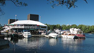
Dow's Lake in Ottawa, Ontario, Canada is a small man-made lake on the Rideau Canal, situated two kilometres north of Hog's Back Falls in the middle of Ottawa. It is at the southern end of Preston Street, just south of Carling Avenue, and just to the west of Bronson Avenue. At the southern end of the lake is Carleton University, and to its west is the Dominion Arboretum, at the edge of the Central Experimental Farm.

Blessed Sacrament Catholic Church (Ottawa)
Church in Ottawa, Ontario
Distance: Approx. 963 meters
Latitude and longitude: 45.400047,-75.693355
Blessed Sacrament Catholic Church is a Catholic church in the Glebe neighbourhood of Ottawa, Ontario, Canada. The parish was founded on March 25, 1913, with the first building being a simple chapel. The current building at 194 Fourth Avenue, was built in 1931.

St. Anthony of Padua (Ottawa)
Church in Ottawa, Ontario
Distance: Approx. 562 meters
Latitude and longitude: 45.40576,-75.708
St. Anthony of Padua is a Roman Catholic church at 427 Booth Street in Ottawa, Ontario, Canada, in the heart of Little Italy.

Dow's Lake station
Railway station in Ottawa, Ontario, Canada
Distance: Approx. 492 meters
Latitude and longitude: 45.3975,-75.70944444
Dow's Lake (French: Lac Dow, formerly known as Carling) is an O-Train station on the Trillium Line, one block west of the intersection of Carling Avenue and Preston Street in Ottawa, Ontario. It is named the nearby Dow's Lake, itself also the western terminus of the Rideau Canal skating rink during winters, as well as a key site during the Canadian Tulip Festival in May. The station is also near government offices at the area of Carling Avenue and Booth Street.

Centretown West
Neighbourhood in Ottawa, Ontario, Canada
Distance: Approx. 844 meters
Latitude and longitude: 45.40833333,-75.70833333
Centretown West is a neighbourhood in Ottawa, Ontario, Canada. It lies to the west of Bronson Avenue, east of the O-Train Trillium Line, north of Carling Avenue, and south of Nanny Goat Hill, which is an escarpment to the north of Somerset Street West. To the east lies Centretown, to the north lies Lebreton Flats, to the west lies Hintonburg, and to the south lies Dow's Lake.

Commissioners Park (Ottawa)
Distance: Approx. 346 meters
Latitude and longitude: 45.3983,-75.7034
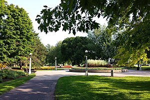
Commissioners Park is a park in Ottawa, Ontario, Canada. It lies within the westernmost section of The Glebe, bounded by Dow's Lake, Preston Street, Carling Avenue and Dow's Lake Road. Throughout the warmer months it is a popular place for family walks.
Gladstone Theatre
Live theatre in Ontario, Canada
Distance: Approx. 796 meters
Latitude and longitude: 45.4043549,-75.714599
The Gladstone is a live theatre in Ottawa, Ontario, Canada. The Gladstone is "Ottawa's Home of Independent Theatre," housing productions by local indie theatre companies. It is located on Gladstone Avenue just west of Preston Street.
Sir John Carling Building
Building in Ontario, Canada
Distance: Approx. 864 meters
Latitude and longitude: 45.39416667,-75.71083333
The Sir John Carling Building was located along Carling Avenue at the Central Experimental Farm, in Ottawa, Ontario, Canada. Until 2010, it was the headquarters of Agriculture and Agri-Food Canada, containing administration facilities and the offices of the Minister and Deputy Minister of Agriculture. Named after John Carling, it was an 11-storey building accommodating some 1,200 employees, with a 3-storey east wing for shipping and receiving and a single-storey cafeteria wing with an arched roof.

Claridge Icon
45-storey condominium tower under construction in Ottawa
Distance: Approx. 355 meters
Latitude and longitude: 45.3981,-75.7075
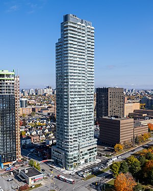
The Claridge Icon is a 45-storey condominium tower in Ottawa, Ontario, Canada. It is located at the intersection of Carling Avenue and Preston Street in Little Italy. When the structure topped out in 2019, it became the tallest building in Ottawa since 1971 and the tallest in Ottawa-Gatineau since 1978.

Corso Italia station
Railway station in Ottawa, Ontario, Canada
Distance: Approx. 776 meters
Latitude and longitude: 45.40416667,-75.71444444
Corso Italia is an infill station on the Trillium Line in Ottawa, Ontario. It services Ottawa's Little Italy neighbourhood. It was constructed as part of the Stage 2 O-Train expansion and opened on January 6, 2025, along with the rest of the reopened Trillium Line, which closed on May 3, 2020, for the extension of the line.
Weather in this IP's area
few clouds
-15 Celsius
-22 Celsius
-16 Celsius
-14 Celsius
1007 hPa
62 %
1007 hPa
994 hPa
10000 meters
7.72 m/s
300 degree
20 %


