192.135.4.55 - IP Lookup: Free IP Address Lookup, Postal Code Lookup, IP Location Lookup, IP ASN, Public IP
Country:
Region:
City:
Location:
Time Zone:
Postal Code:
IP information under different IP Channel
ip-api
Country
Region
City
ASN
Time Zone
ISP
Blacklist
Proxy
Latitude
Longitude
Postal
Route
Luminati
Country
ASN
Time Zone
America/Chicago
ISP
RFC2270-UUNET-CUSTOMER
Latitude
Longitude
Postal
IPinfo
Country
Region
City
ASN
Time Zone
ISP
Blacklist
Proxy
Latitude
Longitude
Postal
Route
IP2Location
192.135.4.55Country
Region
district of columbia
City
washington
Time Zone
America/New_York
ISP
Language
User-Agent
Latitude
Longitude
Postal
db-ip
Country
Region
City
ASN
Time Zone
ISP
Blacklist
Proxy
Latitude
Longitude
Postal
Route
ipdata
Country
Region
City
ASN
Time Zone
ISP
Blacklist
Proxy
Latitude
Longitude
Postal
Route
Popular places and events near this IP address

United States Department of Labor
U.S. federal government department
Distance: Approx. 140 meters
Latitude and longitude: 38.89305556,-77.01444444
The United States Department of Labor (DOL) is one of the executive departments of the U.S. federal government. It is responsible for the administration of federal laws governing occupational safety and health, wage and hour standards, unemployment benefits, reemployment services, and occasionally, economic statistics. It is headed by the secretary of labor, who reports directly to the president of the United States and is a member of the president's Cabinet.

Statue of William Blackstone
Statue by Paul Wayland Bartlett in Washington, D.C., U.S.
Distance: Approx. 183 meters
Latitude and longitude: 38.892404,-77.015814
Sir William Blackstone is a bronze statue by Paul Wayland Bartlett of the English legal scholar William Blackstone. It is located at E. Barrett Prettyman United States Courthouse, at 333 Pennsylvania Avenue in northwest Washington, D.C., in the Judiciary Square neighborhood. It was installed on August 11, 1943.
Ulysses S. Grant Memorial
Presidential memorial in Washington, D.C.
Distance: Approx. 247 meters
Latitude and longitude: 38.88978889,-77.01291389
The Ulysses S. Grant Memorial is a presidential memorial in Washington, D.C., honoring American Civil War general and 18th president of the United States, Ulysses S. Grant. It sits at the base of Capitol Hill (Union Square, the Mall, 1st Street NW/SW, between Pennsylvania Avenue and Maryland Avenue), below the west front of the United States Capitol. Its central sculpture of Grant on horseback faces west, overlooking the Capitol Reflecting Pool and facing toward the Lincoln Memorial, which honors Grant's wartime president, Abraham Lincoln.

Robert A. Taft Memorial
Memorial in Washington, D.C., U.S.
Distance: Approx. 253 meters
Latitude and longitude: 38.89277778,-77.01111111
The Robert A. Taft Memorial and Carillon is a carillon in Washington, D.C. dedicated as a memorial to U.S. Senator Robert Alphonso Taft, son of President William Howard Taft. The memorial is located north of the Capitol, on Constitution Avenue between New Jersey Avenue and First Street, N.W. Designed by architect Douglas W. Orr, the memorial consists of a Tennessee marble tower and a 10-foot (3.0 m) bronze statue of Senator Taft sculpted by Wheeler Williams. The shaft of the tower measures 100 feet (30 m) high, 11 feet (3.4 m) deep, and 32 feet (9.8 m) wide.

Peace Monument
Monument at the United States Capitol
Distance: Approx. 190 meters
Latitude and longitude: 38.89063333,-77.01233056
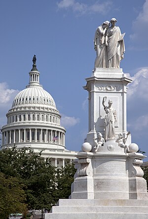
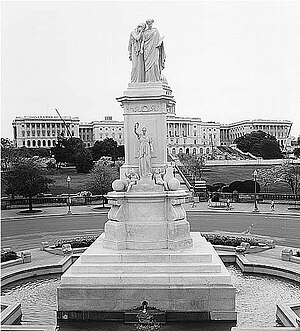
The Peace Monument, also known as the Navy Monument, Naval Monument or Navy-Peace Monument, stands on the western edge of the United States Capitol Complex in Washington, D.C. It is in the middle of Peace Circle, where First Street and Pennsylvania Avenue NW intersect. The surrounding area is Union Square, which the monument shares with the Ulysses S. Grant Memorial, James A. Garfield Monument, and the Capitol Reflecting Pool. The front of the monument faces west towards the National Mall while the east side faces the United States Capitol.

Peace Circle
Traffic circle in Washington, D.C.
Distance: Approx. 203 meters
Latitude and longitude: 38.8905,-77.0123
Peace Circle is a traffic circle in Washington, D.C., located at the intersection of Pennsylvania Avenue and First Street NW. At its center is the Peace Monument, also known as the Naval Memorial. It is a monument to the naval deaths during the American Civil War. The monument is topped by the allegorical sculptures of Grief and History.

Capitol Reflecting Pool
Reflecting pool in Washington, D.C., U.S.
Distance: Approx. 234 meters
Latitude and longitude: 38.8898,-77.0137
The Capitol Reflecting Pool is a reflecting pool in Washington, D.C., United States. It lies to the west of the United States Capitol and is the westernmost element of the Capitol grounds (or the easternmost element of the National Mall, according to some reckonings). The Capitol Dome and the Ulysses S. Grant Memorial are reflected in its waters.
Purple Tunnel of Doom
Distance: Approx. 245 meters
Latitude and longitude: 38.8897468,-77.0143747
Purple Tunnel of Doom was the name ascribed to the I-395 Third Street tunnel in downtown Washington, D.C., where thousands of holders of purple tickets lined up to witness the first inauguration of Barack Obama on January 20, 2009. Ticket colors corresponded to assigned viewing areas. Many were not admitted, despite having stood in line for hours.

George Gordon Meade Memorial
Public artwork by Charles Grafly
Distance: Approx. 231 meters
Latitude and longitude: 38.892131,-77.016444
The George Gordon Meade Memorial, also known as the Meade Memorial or Major General George Gordon Meade, is a public artwork in Washington, D.C. honoring George Meade, a career military officer from Pennsylvania who is best known for defeating General Robert E. Lee at the Battle of Gettysburg. The monument is sited on the 300 block of Pennsylvania Avenue NW in front of the E. Barrett Prettyman United States Courthouse. It was originally located at Union Square, but was removed and placed in storage for fourteen years before being installed at its current location.

Union Square (Washington, D.C.)
Public plaza in Washington, D.C.
Distance: Approx. 234 meters
Latitude and longitude: 38.8898,-77.0137
Union Square is an 11-acre public plaza at the foot of Capitol Hill in Washington, D.C., United States. It encompasses the Ulysses S. Grant Memorial (1924) and the 6-acre Capitol Reflecting Pool (1971) and is just west of the United States Capitol building. Views differ as to whether the Square is just east of the National Mall or is itself the eastern end.
Vincent R. Sombrotto Park
Park in Washington, D.C., U.S.
Distance: Approx. 234 meters
Latitude and longitude: 38.8934,-77.0119
Vincent R. Sombrotto Park is on National Park Service property (Reservation No. 727) in northwest Washington, D.C., bordered by Louisiana Avenue, 1st Street and C Street in the Swampoodle neighborhood. It is across from the National Association of Letter Carriers (NALC) and is named for Vincent Sombrotto, NALC president from 1979 to 2002.

Trinity Episcopal Church (Washington, D.C.)
Building in DC, United-States
Distance: Approx. 192 meters
Latitude and longitude: 38.893377,-77.014946
Trinity Episcopal Church was an Episcopal church that stood from 1851 to 1936 on the northeast corner of 3rd and C Streets NW in the Judiciary Square neighborhood of Washington, D.C. Founded in 1827, the parish was home to prominent attendees including President John Quincy Adams, Senator Daniel Webster, and Francis Scott Key, who served as the church's senior warden. The first church building was located on 5th Street NW, across the street from District of Columbia City Hall, in what was then a fashionable area of the city. The parish grew and began planning a new church building.
Weather in this IP's area
clear sky
1 Celsius
-4 Celsius
-1 Celsius
2 Celsius
1021 hPa
36 %
1021 hPa
1019 hPa
10000 meters
5.14 m/s
8.75 m/s
280 degree
