192.135.204.72 - IP Lookup: Free IP Address Lookup, Postal Code Lookup, IP Location Lookup, IP ASN, Public IP
Country:
 USA
USARegion:
City:
Location:
Time Zone:
Postal Code:
ISP:
ASN:
language:
User-Agent:
Proxy IP:
Blacklist:
IP information under different IP Channel
ip-api
Country
Region
City
ASN
Time Zone
ISP
Blacklist
Proxy
Latitude
Longitude
Postal
Route
db-ip
Country
Region
City
ASN
Time Zone
ISP
Blacklist
Proxy
Latitude
Longitude
Postal
Route
IPinfo
Country
Region
City
ASN
Time Zone
ISP
Blacklist
Proxy
Latitude
Longitude
Postal
Route
IP2Location
192.135.204.72Country
usRegion
texas
City
mission
Time Zone
America/Chicago
ISP
Language
User-Agent
Latitude
Longitude
Postal
ipdata
Country
Region
City
ASN
Time Zone
ISP
Blacklist
Proxy
Latitude
Longitude
Postal
Route
Popular places and events near this IP address

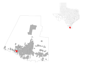
Mission, Texas
City in Texas, United States
Distance: Approx. 649 meters
Latitude and longitude: 26.21138889,-98.32138889
Mission is a city in Hidalgo County, in the US state of Texas, United States. The population was 85,778 at the 2020 census and an estimated 86,635 in 2022. Mission is part of the McAllen–Edinburg–Mission and Reynosa–McAllen metropolitan areas.

Palmhurst, Texas
City in Texas
Distance: Approx. 4284 meters
Latitude and longitude: 26.25083333,-98.3075
Palmhurst is a city in Hidalgo County, Texas, United States. The population was 2,607 at the 2010 United States Census. It is part of the McAllen–Edinburg–Mission and Reynosa–McAllen metropolitan areas.

Palmview, Texas
City in Texas
Distance: Approx. 5140 meters
Latitude and longitude: 26.22666667,-98.37555556
Palmview is a city in Hidalgo County, Texas, United States. The population is 17,410 as of the 2020 United States Census. It is part of the McAllen–Edinburg–Mission and Reynosa–McAllen metropolitan areas.
Palmview South, Texas
Census-designated place in Texas
Distance: Approx. 4934 meters
Latitude and longitude: 26.21972222,-98.37472222
Palmview South is a census-designated place (CDP) in Hidalgo County, Texas, United States. The population was 2,008 at the 2020 United States Census. It is part of the McAllen–Edinburg–Mission Metropolitan Statistical Area.

Mission High School (Mission, Texas)
Public school in Mission, Texas, United States
Distance: Approx. 889 meters
Latitude and longitude: 26.22305556,-98.32944444
Mission High School is a secondary school located in Mission, Texas. It is a part of the Mission Consolidated Independent School District. It serves sections of Mission, Palmhurst, and Alton, as well as the Mission CISD portion of the unincorporated area of West Sharyland.
Sharyland High School
Public school in Texas, United States
Distance: Approx. 4191 meters
Latitude and longitude: 26.21361111,-98.28361111
Sharyland High School is a high school in Mission, Texas, United States. The school, which is classified as "5A" by the UIL, is a part of the Sharyland Independent School District. The school primarily serves Sharyland, an unincorporated rural area known for its agricultural and citrus industry.
First Lift Station
United States historic place
Distance: Approx. 691 meters
Latitude and longitude: 26.21194444,-98.33083333
The First Lift Station is a pump station in Mission, Texas, that once provided water for irrigating the crops of the early Rio Grande Valley. In 1907 John J. Conway and James W. Hoit began the Mission Canal Co. Irrigation system, which was instrumental in the early agricultural growth of the area.

Border Theater
United States historic place
Distance: Approx. 106 meters
Latitude and longitude: 26.215,-98.32583333
The Border Theater is a historic movie theater in Mission, Texas. Located at 905 North Conway Boulevard it is in the city's central business district. Built in 1942 it continues to operate as an entertainment venue.

KQXX-FM
Radio station in Mission, Texas
Distance: Approx. 2075 meters
Latitude and longitude: 26.23055556,-98.33833333
KQXX-FM (105.5 FM, "Kiss FM 105.5 & 106.3") is a radio station broadcasting a Hot Adult Contemporary music format, simulcasting its sister station KHKZ. Licensed to Mission, Texas, United States, the station serves the McAllen area. The station is currently owned by iHeartMedia. It shares a studio with its sister stations, KHKZ, KBFM, KTEX, and KVNS, located close to the KRGV-TV studios in Weslaco, Texas, while its transmitter is located in Mission, Texas.

Mission Citrus Growers Union Packing Shed
United States historic place
Distance: Approx. 672 meters
Latitude and longitude: 26.21555556,-98.33222222
The Mission Citrus Growers Union Packing Shed in Mission, Texas, also known as Edinburg Citrus Association and as Growers Select Produce Packing Shed, is a historic packing house. It was built in 1944. It was listed on the National Register of Historic Places in 2002.
Veterans Memorial High School (Mission, Texas)
Distance: Approx. 3072 meters
Latitude and longitude: 26.2419,-98.3152
Veterans Memorial High School is a senior high school in Mission, Texas and a part of the Mission Consolidated Independent School District. It was made in 2002 and had the first graduation in 2004. It serves sections of Mission, Alton, and Palmhurst.

National Butterfly Center
Butterfly conservatory in Mission, Texas, United States
Distance: Approx. 5600 meters
Latitude and longitude: 26.1802,-98.365
The National Butterfly Center is a private nature preserve operated by the North American Butterfly Association that serves as an outdoor butterfly conservatory. It is located adjacent to Bentsen-Rio Grande Valley State Park, near the city of Mission in Hidalgo County in the U.S. state of Texas.
Weather in this IP's area
overcast clouds
22 Celsius
23 Celsius
22 Celsius
23 Celsius
1015 hPa
85 %
1015 hPa
1009 hPa
10000 meters
6.69 m/s
150 degree
100 %