Country:
Region:
City:
Latitude and Longitude:
Time Zone:
Postal Code:
IP information under different IP Channel
ip-api
Country
Region
City
ASN
Time Zone
ISP
Blacklist
Proxy
Latitude
Longitude
Postal
Route
Luminati
Country
ASN
Time Zone
Europe/Paris
ISP
Orange
Latitude
Longitude
Postal
IPinfo
Country
Region
City
ASN
Time Zone
ISP
Blacklist
Proxy
Latitude
Longitude
Postal
Route
db-ip
Country
Region
City
ASN
Time Zone
ISP
Blacklist
Proxy
Latitude
Longitude
Postal
Route
ipdata
Country
Region
City
ASN
Time Zone
ISP
Blacklist
Proxy
Latitude
Longitude
Postal
Route
Popular places and events near this IP address

Château de Vincennes
Former fortress and royal residence adjacent to Vincennes, France
Distance: Approx. 888 meters
Latitude and longitude: 48.84277778,2.43583333
The Château de Vincennes (French pronunciation: [ʃɑto d(ə) vɛ̃sɛn]) is a former fortress and royal residence next to the town of Vincennes, on the eastern edge of Paris, alongside the Bois de Vincennes. It was largely built between 1361 and 1369, and was a preferred residence, after the Palais de la Cité, of French kings in the 14th to 16th century. It is particularly known for its "donjon" or keep, a fortified central tower, the tallest in Europe, built in the 14th century, and for the chapel, Sainte-Chapelle de Vincennes, begun in 1379 but not completed until 1552, which is an exceptional example of Flamboyant Gothic architecture.

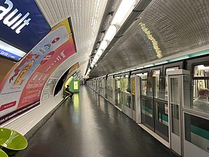
Bérault station
Metro station in Paris, France
Distance: Approx. 283 meters
Latitude and longitude: 48.84527778,2.42833333
Bérault (French: [beʁo] ) is a station on Paris Métro Line 1. It is situated at the boundary between the communes of Saint-Mandé and Vincennes. It is named after the nearby Place Bérault, which honors a former deputy mayor of Vincennes (1796–1871).
Saint-Mandé
Commune in Île-de-France, France
Distance: Approx. 575 meters
Latitude and longitude: 48.8422,2.4186
Saint-Mandé (French pronunciation: [sɛ̃ mɑ̃de] ) is a high-end commune of the Val-de-Marne department in Île-de-France in the eastern suburbs of Paris, France. It is located 5.3 km (3.3 mi) from the centre of Paris. It is one of the smallest communes of the Île-de-France by land area, but is one of the most densely populated municipalities in Europe.

Saint-Mandé station
Metro station in Paris, France
Distance: Approx. 415 meters
Latitude and longitude: 48.84611111,2.41888889
Saint-Mandé (French pronunciation: [sɛ̃ mɑ̃de]) is a station on Line 1 of the Paris Métro, which is located in the commune of Saint-Mandé, just outside the Boulevard Périphérique. It was called Tourelle until 1937, when it was renamed Saint-Mandé - Tourelle. On 26 July 2002, "Tourelle" was dropped from the name.

Vincennes station
Distance: Approx. 691 meters
Latitude and longitude: 48.84742,2.433524
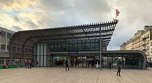
Vincennes station (French pronunciation: [vɛ̃sɛn] ) is a station on RER A the commune of Vincennes, Val-de-Marne.

Defence Historical Service
Archives centre of the French Ministry of Defence
Distance: Approx. 891 meters
Latitude and longitude: 48.843,2.436
In France, the Defence Historical Service (Service historique de la défense; SHD) is the archives centre of Ministry of Defence and its armed forces. It was set up by decree in 2005. The SHD consists of the "Centre historique des archives" at Vincennes, the "Centre des archives de l’armement et du personnel" at Châtellerault and a number of smaller repositories.
Porte de Vincennes
Distance: Approx. 997 meters
Latitude and longitude: 48.84722222,2.41111111
The Porte de Vincennes (French pronunciation: [pɔʁt də vɛ̃sɛn]) is one of the city gates of Paris (France) situated in the Bel Air neighborhood of the 12th arrondissement.
Vincennes Synagogue
Synagogue in Vincennes, France
Distance: Approx. 431 meters
Latitude and longitude: 48.8477,2.41956
The Vincennes Synagogue is a Jewish congregation and synagogue, located at 30 rue Céline Robert, Vincennes, in the Val-de-Marne department of the Île-de-France région of France. Designed by Victor Tondu and funded by Daniel Iffla, the stone synagogue was established in 1907.

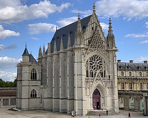
Sainte-Chapelle de Vincennes
Chapel located in Vincennes, Val-de-Marne, France
Distance: Approx. 946 meters
Latitude and longitude: 48.8423,2.4364
The Sainte-Chapelle de Vincennes is a Gothic royal chapel within the fortifications of the Château de Vincennes on the east edge of Paris, France. It was inspired by the Sainte-Chapelle, the royal chapel within the Palais de la Cité in Paris. It was begun in 1379 by Charles V of France to house relics of the Passion of Christ.

Bégin Military Teaching Hospital
Hospital in Saint-Mandé, France
Distance: Approx. 269 meters
Latitude and longitude: 48.8436003,2.4265623
Bégin Military Teaching Hospital (French: Hôpital d'instruction des armées Bégin) is a military hospital at 69, avenue de Paris, in Saint-Mandé in the Val-de-Marne, near Paris. It is named after Louis Jacques Bégin, military surgeon of the French Empire.

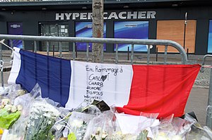
Hypercacher kosher supermarket siege
2015 Islamist terrorist attack in Paris
Distance: Approx. 685 meters
Latitude and longitude: 48.846963,2.415386
On 9 January 2015, Amedy Coulibaly, armed with a submachine gun, an assault rifle, and two Tokarev pistols, entered and attacked a Hypercacher kosher supermarket in Porte de Vincennes in Paris, France. There, Coulibaly murdered four Jewish hostages and held fifteen other hostages during a siege in which he demanded that the perpetrators of the Charlie Hebdo shooting, the Kouachi brothers, not be harmed. The siege ended when police stormed the supermarket, killing Coulibaly.

Chaussée de l'Étang
Distance: Approx. 703 meters
Latitude and longitude: 48.8398,2.4207
The Chaussée de l’Étang is a street in the city of Saint-Mandé in the Val-de-Marne and, since 1992, part of the 12th arrondissement of Paris, France (more precisely the "Bel-Air" southern neighbourhood). The buildings are located on the even numbers side, under the administration of the city of Saint-Mandé. The other side being the Bois de Vincennes, attached to the 12th arrondissement, administrated by the City of Paris.
Weather in this IP's area
overcast clouds
11 Celsius
11 Celsius
10 Celsius
13 Celsius
1022 hPa
95 %
1022 hPa
1016 hPa
9000 meters
1.54 m/s
100 %
07:43:57
17:23:50


