Country:
 Sweden
Region:
City:
Latitude and Longitude:
Time Zone:
Postal Code:
IP information under different IP Channel
ip-api
Country
Region
City
ASN
Time Zone
ISP
Blacklist
Proxy
Latitude
Longitude
Postal
Route
IPinfo
Country
Region
City
ASN
Time Zone
ISP
Blacklist
Proxy
Latitude
Longitude
Postal
Route
MaxMind
Country
Region
City
ASN
Time Zone
ISP
Blacklist
Proxy
Latitude
Longitude
Postal
Route
Luminati
Country
SERegion
s
City
karlstad
ASN
Time Zone
Europe/Stockholm
ISP
Telia Company AB
Latitude
Longitude
Postal
db-ip
Country
Region
City
ASN
Time Zone
ISP
Blacklist
Proxy
Latitude
Longitude
Postal
Route
ipdata
Country
Region
City
ASN
Time Zone
ISP
Blacklist
Proxy
Latitude
Longitude
Postal
Route
Popular places and events near this IP address
Karlstad Municipality
Municipality in Värmland County, Sweden
Distance: Approx. 2223 meters
Latitude and longitude: 59.38333333,13.53333333
Karlstad Municipality (Swedish: Karlstads kommun) is a municipality in Värmland County in west central Sweden. Its seat is located in the city of Karlstad. The present municipality was established in 1971 when the former City of Karlstad was amalgamated with a number of surrounding rural municipalities.
Klarälven
River in Norway and Sweden
Distance: Approx. 1059 meters
Latitude and longitude: 59.38861111,13.49833333
Klarälven ("The clear river" in Swedish) is a river flowing through Norway and Sweden. Together with Göta älv, which it is called as the river has passed through the lake Vänern, thus regarded as an entity, Göta älv—Klarälven is the longest river in Scandinavia and in the Nordic countries and its Swedish part the longest river of Sweden. These two rivers also have the largest drainage basin in the same areas, 50,229 km2 (19,394 sq mi) including all the rivers that run into Vänern, of which 42,468 km2 (16,397 sq mi) is located in Sweden and 7,761 km2 (2,997 sq mi) in Norway.

Karlstad
Episcopal see and municipal seat in Värmland, Sweden
Distance: Approx. 2124 meters
Latitude and longitude: 59.37833333,13.50416667
Karlstad (US: , Swedish: [ˈkɑ̌ːɭsta(d)] ) is the 20th-largest city in Sweden, the seat of Karlstad Municipality, the capital of Värmland County, and the largest city in the province Värmland in Sweden. The city proper had 67,122 inhabitants in 2020 with 97,233 inhabitants in the wider municipality in 2023, and is the 21st biggest municipality in Sweden. Karlstad has a university and a cathedral.
Värmland Regiment
Swedish Army infantry regiment
Distance: Approx. 1385 meters
Latitude and longitude: 59.38777778,13.49
The Värmland Regiment (Swedish: Värmlands regemente), designations I 22, I 2 and I 2/Fo 52, was a Swedish Army infantry regiment that traces its origins back to the 16th century. The regiment's soldiers were originally recruited from the province of Värmland, where the unit was later garrisoned. The unit was disbanded as a result of the disarmament policies set forward in the Defence Act of 2000.

Diocese of Karlstad
Distance: Approx. 1752 meters
Latitude and longitude: 59.38166667,13.50638889
The Diocese of Karlstad (Swedish: Karlstads stift) is a diocese of the Church of Sweden with its episcopal see in the city of Karlstad. It covers most of the provinces Värmland and Dalsland. Its current borders are from 1693.

Löfbergs Arena
Distance: Approx. 1155 meters
Latitude and longitude: 59.4075,13.50083333
Löfbergs Arena is an arena located in Karlstad, Sweden, situated just above the river delta of Klarälven. It is primarily used for ice hockey, and is the home arena of Färjestad BK. It opened in 2001 following a complete overhaul and major expansion of the previously existing arena Färjestads Ishall. It replaced Färjestads Ishall as the home of Färjestad and has a capacity of 8,647 people.

Tingvallagymnasiet
Secondary school in Karlstad, Sweden
Distance: Approx. 1854 meters
Latitude and longitude: 59.38075,13.50491667
Tingvallagymnasiet (Tingvalla upper secondary school) is an upper secondary school in Karlstad, Sweden, offering education programmes both in the social and natural sciences.
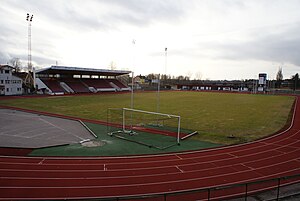
Tingvalla IP
Sports venue in Karlstad, Sweden
Distance: Approx. 1372 meters
Latitude and longitude: 59.38666667,13.49361111
Tingvalla Idrottsplats (abbreviated as Tingvalla IP) is a stadium in Karlstad, Sweden and is the home ground of the football team Carlstad United and the American football team Carlstad Crusaders. It is also used for athletic events and other sports and gatherings. Built in 1919, it has a capacity of 10,000 (of which only 1,100 are seated).
Färjestads Ishall
Distance: Approx. 1155 meters
Latitude and longitude: 59.4075,13.50083333
Färjestads Ishall was an arena in Karlstad, Sweden. It was the home arena for the ice hockey team Färjestads BK. It opened on 4 November 1967 with the Swedish top division game Färjestads BK–Djurgårdens IF., where Färjestads BK won, 8–4. For a long time it held 8,000 people during sport events, but the capacity was later reduced to 4,700 when seating became common standard.

Karlstad Cathedral
Church in Karlstad, Sweden
Distance: Approx. 1752 meters
Latitude and longitude: 59.38166667,13.50638889
Karlstad Cathedral (Swedish: Karlstads domkyrka) is a cathedral in Karlstad, Sweden. The church is located in the middle of Karlstad on Lagberget on Tingvalla island. It belongs to Karlstad Cathedral Parish of the Diocese of Karlstad of the Church of Sweden.

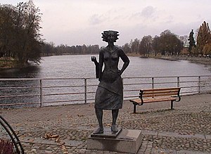
Sola i Karlstad
Swedish waitress, innkeeper, and local symbol (1739–1818)
Distance: Approx. 1812 meters
Latitude and longitude: 59.38138889,13.49972222
Sola i Karlstad ("the Sun in Karlstad"), nickname of Eva Lisa Holtz (1 January 1739, Karlstad – 24 September 1818), was a Swedish waitress and innkeeper who became the symbol of the Swedish city of Karlstad. She worked as a waitress at several of the local inns in Karlstad, and came to be known for her "sunny" disposition, thereby being given the nickname "the Sun in Karlstad".

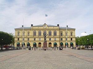
Karlstad Central Station
Railway station in Karlstad, Sweden
Distance: Approx. 2214 meters
Latitude and longitude: 59.37777778,13.49916667
Karlstad Central Station is located in Karlstad, Sweden, along the Värmland Line. The station is located around 300 metres (980 ft) from traditional midpoint of the city. City buses and some regional buses stop at the station, while the regional bus station is around 400 metres (1,300 ft) away from the railway station.
Weather in this IP's area
fog
8 Celsius
8 Celsius
8 Celsius
8 Celsius
1035 hPa
93 %
1035 hPa
1029 hPa
300 meters
1.54 m/s
360 degree
100 %
06:44:13
19:15:16