Country:
 Israel
Region:
City:
Latitude and Longitude:
Time Zone:
Postal Code:
IP information under different IP Channel
ip-api
Country
Region
City
ASN
Time Zone
ISP
Blacklist
Proxy
Latitude
Longitude
Postal
Route
IPinfo
Country
Region
City
ASN
Time Zone
ISP
Blacklist
Proxy
Latitude
Longitude
Postal
Route
MaxMind
Country
Region
City
ASN
Time Zone
ISP
Blacklist
Proxy
Latitude
Longitude
Postal
Route
Luminati
Country
ILRegion
d
City
beersheba
ASN
Time Zone
Asia/Jerusalem
ISP
Partner Communications Ltd.
Latitude
Longitude
Postal
db-ip
Country
Region
City
ASN
Time Zone
ISP
Blacklist
Proxy
Latitude
Longitude
Postal
Route
ipdata
Country
Region
City
ASN
Time Zone
ISP
Blacklist
Proxy
Latitude
Longitude
Postal
Route
Popular places and events near this IP address
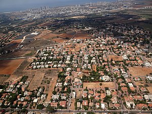
Even Yehuda
Local council in Central, Israel
Distance: Approx. 490 meters
Latitude and longitude: 32.270025,34.88742778
Even Yehuda (Hebrew: אֶבֶן יְהוּדָה) is a town in the central Sharon region of Israel east of Netanya. In 2022 it had a population of 14,365.

Kadima-Zoran
Local council in Israel
Distance: Approx. 2691 meters
Latitude and longitude: 32.27611111,34.91111111
Kadima-Zoran (Hebrew: קדימה-צורן), also known as Kadima-Tzoran, is a local council in the Central District of Israel. The result of the 2003 union of the Tzoran and Kadima councils, in 2022 it had a population of 23,220. Kadima-Zoran is home to the "Ta'am Shel Pa'am" (A Taste of Old Times) museum for the history of the settlement in the elementary school Nitzanei HaSharon.
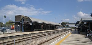
Beit Yehoshua railway station
Railway station in Israel
Distance: Approx. 2372 meters
Latitude and longitude: 32.26283333,34.86026389
Bet Yehoshua railway station (Hebrew: תחנת הרכבת בית יהושע, Taḥanat HaRakevet Beit Yehoshua) is an Israel Railways passenger station located in Beit Yehoshua and serves the village and the southern part of the city of Netanya, with its large industrial zones, as well as other small communities in the area.

The Sergeants affair
1947 incident in Mandate Palestine
Distance: Approx. 490 meters
Latitude and longitude: 32.270025,34.88742778
The Sergeants affair (Hebrew: פרשת הסרג'נטים) was an incident that took place in Mandate Palestine in July 1947 during Jewish insurgency in Palestine, in which the Jewish underground group Irgun kidnapped two British Army Intelligence Corps NCOs, Sergeant Clifford Martin and Sergeant Mervyn Paice, and threatened to hang them if the death sentences passed on three Irgun militants—Avshalom Haviv, Meir Nakar, and Yaakov Weiss—were carried out. The three had been captured by the British during the Acre Prison break, tried, and convicted on charges of illegal possession of arms, and with 'intent to kill or cause other harm to a large number of people'. When the three men were executed by hanging, the Irgun killed the two sergeants and hung their booby-trapped bodies in a eucalyptus grove near Netanya.

Tel Yitzhak
Kibbutz in central Israel
Distance: Approx. 2546 meters
Latitude and longitude: 32.2525,34.86916667
Tel Yitzhak (Hebrew: תֵּל יִצְחָק, lit. 'Yitzhak Hill') is a kibbutz in central Israel. Located in the coastal plain to the south-east of Netanya, it falls under the jurisdiction of Hof HaSharon Regional Council. In 2022 it had a population of 834.

Beit Yehoshua
Moshav in central Israel
Distance: Approx. 2239 meters
Latitude and longitude: 32.26111111,34.86305556
Beit Yehoshua (Hebrew: בֵּית יְהוֹשֻעַ, lit. 'House of Yehoshua') is a moshav in central Israel. Located in the coastal plain near Netanya, it falls under the jurisdiction of Hof HaSharon Regional Council. In 2022 it had a population of 1,117.
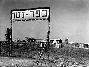
Kfar Netter
Moshav in central Israel
Distance: Approx. 1191 meters
Latitude and longitude: 32.27138889,34.87027778
Kfar Netter (Hebrew: כְּפַר נֶטֶר, lit. 'Netter Village') is a moshav in central Israel. Located in the coastal plain near Netanya, it falls under the jurisdiction of Hof HaSharon Regional Council. In 2022 it had a population of 1,143.

Neve Hadassah
Youth village in central Israel
Distance: Approx. 2477 meters
Latitude and longitude: 32.25083333,34.87555556
Neve Hadassah (Hebrew: נְוֵה הֲדַסָּה, lit. 'Hadassah Abode') is a youth village in central Israel. Located in the Sharon plain near Netanya and adjacent to Tel Yitzhak, it falls under the jurisdiction of Hof HaSharon Regional Council. In 2006 it had a population of 668.

Bnei Dror
Moshav in central Israel
Distance: Approx. 2098 meters
Latitude and longitude: 32.26166667,34.90138889
Bnei Dror (Hebrew: בְּנֵי דְּרוֹר, lit. Sons of Liberty) is a moshav shitufi in central Israel. Located near Netanya and covering 3,200 dunams, it falls under the jurisdiction of Lev HaSharon Regional Council.

Ghabat Kafr Sur
Village in Tulkarm, Mandatory Palestine
Distance: Approx. 1948 meters
Latitude and longitude: 32.28388889,34.8675
Ghabat Kafr Sur was a Palestinian village in the Tulkarm Subdistrict of Mandatory Palestine. It was depopulated during the 1948 Arab–Israeli War on May 15, 1948, under Operation Coastal Clearing. It was located 16 km southwest of Tulkarm.
Walworth Barbour American International School
Private international school in Even Yehuda, Merkaz, Israel
Distance: Approx. 970 meters
Latitude and longitude: 32.26476345,34.87752025
The Walworth Barbour American International School in Israel (WBAIS) is an independent, American-curriculum, English-language school. It is composed of a campus with a preschool, elementary, middle, and high school (PK3-12) in Even Yehuda; and the Jerusalem American International School (pre-school through 12th grade). WBAIS is accredited by the Middle States Association of Colleges and Schools and is a member of the Near East South Asia Council of Overseas Schools.
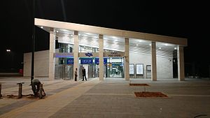
Netanya Sapir railway station
Railway station in Israel
Distance: Approx. 1910 meters
Latitude and longitude: 32.28027778,34.865
Netanya Sapir railway station (Hebrew: תחנת הרכבת נתניה ספיר, Taḥanat HaRakevet Netanya Sapir) is an Israel Railways station located in the Sapir (more commonly known as Poleg) commercial/industrial zone in southern Netanya, on the North-South coastal line.
Weather in this IP's area
few clouds
25 Celsius
25 Celsius
24 Celsius
27 Celsius
1012 hPa
69 %
1012 hPa
1006 hPa
10000 meters
3.59 m/s
4.24 m/s
285 degree
20 %
06:25:04
18:45:39