Country:
 Israel
Region:
City:
Latitude and Longitude:
Time Zone:
Postal Code:
IP information under different IP Channel
ip-api
Country
Region
City
ASN
Time Zone
ISP
Blacklist
Proxy
Latitude
Longitude
Postal
Route
IPinfo
Country
Region
City
ASN
Time Zone
ISP
Blacklist
Proxy
Latitude
Longitude
Postal
Route
MaxMind
Country
Region
City
ASN
Time Zone
ISP
Blacklist
Proxy
Latitude
Longitude
Postal
Route
Luminati
Country
ILRegion
ta
City
batyam
ASN
Time Zone
Asia/Jerusalem
ISP
Partner Communications Ltd.
Latitude
Longitude
Postal
db-ip
Country
Region
City
ASN
Time Zone
ISP
Blacklist
Proxy
Latitude
Longitude
Postal
Route
ipdata
Country
Region
City
ASN
Time Zone
ISP
Blacklist
Proxy
Latitude
Longitude
Postal
Route
Popular places and events near this IP address

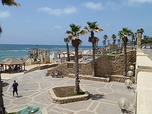
Bat Yam
City in Israel
Distance: Approx. 1529 meters
Latitude and longitude: 32.01666667,34.75
Bat Yam (Hebrew: בַּת יָם or בַּת־יָם ) is a city located on Israel's Mediterranean Sea coast, on the Central Coastal Plain just south of Tel Aviv. It is part of the Gush Dan metropolitan area and the Tel Aviv District. In 2020, it had a population of 160,000.
Al Gal
Distance: Approx. 964 meters
Latitude and longitude: 32.017246,34.73819
Al Gal is a beach area located on the west coast of Israel near the city of Bat Yam. It is an exposed beach break and reef break that has fairly consistent surf, specially during the months of summer when most of the surf comes in the form of wind waves. Al Gal is regarded to be one of the best surf spots in the Middle East.
Peres Center for Peace
Israeli organization for the promotion of peace and innovation.
Distance: Approx. 1472 meters
Latitude and longitude: 32.0372,34.7461
The Peres Center for Peace and Innovation, located in Jaffa, Israel, is an independent non-profit, non-governmental, and non-political organization founded in 1996 by Nobel Peace Laureate and former President of Israel Shimon Peres. Its aim is to further Peres' vision of people in the Middle East working together to build peace through socio-economic cooperation and development and people-to-people interaction.
Giv'at Aliyah
Distance: Approx. 1458 meters
Latitude and longitude: 32.03643889,34.74718056
Giv'at Aliyah is a residential neighborhood of Tel Aviv, Israel. It is located in the southern part of Jaffa.

Wolfson Medical Center
Wolfson Medical Center in Israel
Distance: Approx. 2585 meters
Latitude and longitude: 32.03527778,34.76305556
Wolfson Medical Center (Hebrew: מרכז רפואי וולפסון) (transliteration: Merkaz Refui Wolfson) is a hospital in the Tel Aviv District city of Holon, Israel. Wolfson Hospital is located in southern Tel Aviv Metropolitan Area in a vicinity abounded by a population of nearly half a million inhabitants. It ranks as the ninth largest hospital in Israel.

Murder of Helena Rapp
1992 Palestinian terrorist attack in Bat Yam, Israel
Distance: Approx. 550 meters
Latitude and longitude: 32.02111111,34.73944444
The murder of Helena Rapp occurred on 24 May 1992 when a Palestinian stabbed 15-year-old Israeli Helena Rapp to death in the Israeli coastal city of Bat Yam. The attack shocked the Israeli public as one of the more prominent of a series of stabbing attacks that took place in Israel during the early 1990s. Following the attack, riots broke out in Bat Yam until they were dispersed by police five days later.

Holon–Wolfson railway station
Railway station on the Hod Hasharon Sokolov–Sderot line in Israel
Distance: Approx. 2300 meters
Latitude and longitude: 32.03527778,34.75972222
Holon–Wolfson railway station is a railway station in the border of Holon and Jaffa in the south of Tel Aviv-Yafo Municipality, on the Rosh HaAyin–Beersheba line. The station is in the Wolfson interchange on the Ayalon Highway, nearby Wolfson Medical Center.

Bat Yam–Yoseftal railway station
Railway station in Israel
Distance: Approx. 2565 meters
Latitude and longitude: 32.015,34.76194444
Bat Yam–Yoseftal railway station is a railway station on the Rosh HaAyin–Beersheba line. It is located at the Yoseftal interchange on the Ayalon Highway, on the border between Bat Yam and Holon, just south of Tel Aviv, Israel.
2013 Bat Yam bus bombing
Distance: Approx. 1617 meters
Latitude and longitude: 32.022,34.7545
On 22 December 2013, at approximately 2:30 pm, a pressure cooker bomb exploded on a public bus in Bat Yam, Israel. All casualties were averted because a few minutes earlier, a passenger on the bus had examined the contents of an unattended bag, and saw what looked like a bomb inside, which led all passengers and the driver to exit the vehicle. The bombing shattered or blew out all windows on the bus, and significantly damaged the interior.

Ajami, Jaffa
Neighborhood in Tel Aviv-Yafo, Israel
Distance: Approx. 2409 meters
Latitude and longitude: 32.045,34.75
Ajami (Arabic: العجمي, Hebrew: עג'מי) is a predominantly Arab neighborhood in Tel Aviv-Yafo, Israel, situated south of Old Jaffa and north of the Jabaliyya neighborhood on the Mediterranean Sea. It developed in the late 19th century following the demolition of the city walls of Jaffa, and by the 1920s was a densely populated urban area.

Neve Nof Tower
Residence in Tel Aviv District, Israel
Distance: Approx. 1690 meters
Latitude and longitude: 32.01083,34.7402
Neve Nof Tower (Hebrew: מגדל נווה נוף) is a residential tower located in the Tel Aviv District city of Bat Yam, Israel. Its construction was completed in 2013 and it became the tallest residential building in Israel, taking the title from Park Tzameret’s ‘’W Tower’’. The tower topped out at 158.5 meters (520 ft) and includes 42 floors.

Adam's Rock
Distance: Approx. 332 meters
Latitude and longitude: 32.0232,34.7365
Adam's Rock (he: סלע אדם – Sela Adam; ar: حجر آدم) or Adam's Island (he: אי אדם – Ie Adam; ar: جزيرة آدم) is a tiny Israeli island about half a kilometer west of Bat Yam. A smaller rock (island) is located 10 m west of Adam Rock.
Weather in this IP's area
few clouds
22 Celsius
21 Celsius
21 Celsius
22 Celsius
1014 hPa
61 %
1014 hPa
1014 hPa
10000 meters
1.54 m/s
20 %
06:47:23
18:04:13