Country:
 Israel
Region:
City:
Latitude and Longitude:
Time Zone:
Postal Code:
IP information under different IP Channel
ip-api
Country
Region
City
ASN
Time Zone
ISP
Blacklist
Proxy
Latitude
Longitude
Postal
Route
IPinfo
Country
Region
City
ASN
Time Zone
ISP
Blacklist
Proxy
Latitude
Longitude
Postal
Route
MaxMind
Country
Region
City
ASN
Time Zone
ISP
Blacklist
Proxy
Latitude
Longitude
Postal
Route
Luminati
Country
ILRegion
z
City
nahariya
ASN
Time Zone
Asia/Jerusalem
ISP
Partner Communications Ltd.
Latitude
Longitude
Postal
db-ip
Country
Region
City
ASN
Time Zone
ISP
Blacklist
Proxy
Latitude
Longitude
Postal
Route
ipdata
Country
Region
City
ASN
Time Zone
ISP
Blacklist
Proxy
Latitude
Longitude
Postal
Route
Popular places and events near this IP address

Nahariya
City in Israel
Distance: Approx. 1227 meters
Latitude and longitude: 33.00583333,35.09888889
Nahariya (Hebrew: נַהֲרִיָּה) is the northernmost coastal city in Israel. As of 2022, the city had a population of 63,947. The city was founded in 1935 by Jewish immigrants fleeing Nazi Germany.

Ga'aton River
Distance: Approx. 793 meters
Latitude and longitude: 33.00646667,35.09428056
The Ga'aton Stream (Hebrew: נחל הגעתון, Nahal HaGa'aton; Arabic: وادي المفشوج, Wadi al-Mafshukh) is a small river in the Northern District of Israel. It passes through the town of Nahariya before emptying into the Mediterranean Sea. The river runs through the main street of Nahariya, a city that takes its name from the river (nahar means river in Hebrew).
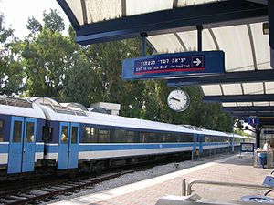
Nahariya railway station
Railway station in Israel
Distance: Approx. 1234 meters
Latitude and longitude: 33.00527778,35.09888889
Nahariya railway station (Hebrew: תחנת רכבת נהריה, romanized: Takhanat Rakevet Nahariya) is a railway station serving the city of Nahariya, Israel, and the surrounding towns and villages of the Western Galilee region. It is the northernmost passenger station in Israel and is currently the terminus of the north–south coastal line. The station is located on Ga'aton Boulevard (Hebrew: שדרות הגעתון, romanized: Sderot HaGe'aton), Nahariya's main street along the Ga'aton River, near the main entrance to the city from the coastal highway ( Highway 4) and across the street from the city's central bus station.

Mazra'a
Arab town in northern Israel
Distance: Approx. 2860 meters
Latitude and longitude: 32.98305556,35.0975
Mazra'a (Arabic: المزرعة, Hebrew: מַזְרַעָה) is an Arab village and local council in northern Israel, situated between Acre and Nahariyya east of the Coastal Highway that runs along the Mediterranean coast. The local council was founded in 1896 and was incorporated into the Matte Asher Regional Council in 1982, before proclaiming itself an independent local council again in 1996. In 2022 it had a population of 4,115.

Evron, Israel
Place in Northern, Israel
Distance: Approx. 2184 meters
Latitude and longitude: 32.99138889,35.10027778
Evron (Hebrew: עֶבְרוֹן) is a kibbutz in northern Israel. Situated in the western Galilee adjacent to Nahariya on the city's southeast border, it falls under the jurisdiction of Mateh Asher Regional Council. In 2022 it had a population of 891.
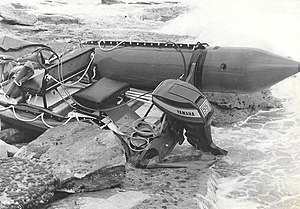
1979 Nahariya attack
1979 terrorist attack in Israel
Distance: Approx. 972 meters
Latitude and longitude: 33.01416667,35.09138889
The 1979 Nahariya attack (codenamed by its perpetrators as the Nasser Operation) was a raid by four Palestine Liberation Front (PLF) militants in Nahariya, Israel on 22 April 1979. The group, consisting of Abdel Majeed Asslan, Mhanna Salim al-Muayed, and Ahmed al-Abras, and led by 16-year-old Samir Kuntar, used a small, 55 horsepower (41 kW) boat to travel from Tyre, Lebanon to Israel. During the attack they killed three Israelis, including a father and two of his young children.

Galilee Medical Center
Hospital in Nahariya, Israel
Distance: Approx. 2896 meters
Latitude and longitude: 33.00944444,35.11666667
Galilee Medical Center (Hebrew: המרכז הרפואי לגליל, HaMerkaz HaRefu'i LaGalil), abbreviated GMC, is a hospital located in the coastal city of Nahariya and is the second largest hospital in northern Israel (after Rambam Hospital in Haifa). It was established in 1956. The hospital located on the outskirts of Nahariya, three kilometers from the city center, serving half a million residents of the western Galilee, from Karmiel to the coast.
Yeshivat Nahariya
School in Nahariyya, Israel
Distance: Approx. 1607 meters
Latitude and longitude: 33.00078333,35.10144167
Yeshivat Hesder Nahariya (also known as Yeshivat Nahar Deiah, Yeshivat Hesder of Nahariya or Nahar Deiah Hesder Yeshiva in Nahariya) is a religious study institution located in the northernmost city in Israel (or Nahariyya), on the Mediterranean coast. It is a Hesder yeshiva, which combines religious Torah study with service in the army and community service. The Yeshivat Hesder Nahriya was founded in 1995 after a rocket attack from the Hezbollah by the Chief Rabbi of Nahariya, Rabbi Yeshayahu Meitlis.
1974 Nahariya attack
Palestinian attack against civilians in northern Israel
Distance: Approx. 472 meters
Latitude and longitude: 33.00444444,35.09
The 1974 Nahariya attack was a raid by three Fatah militants late at night on 24 June 1974. The militants infiltrated the coastal city of Nahariya in Israel by sea from Lebanon in the first attack of its kind in the conflict. Three civilians and one Israeli soldier were killed.
Nahariya train station suicide bombing
2001 suicide bombing in Nahariya, Israel
Distance: Approx. 1204 meters
Latitude and longitude: 33.00555556,35.09861111
The Nahariya train station suicide bombing occurred on September 9, 2001 in the Nahariya Railway Station in Nahariya, Israel. This terror attack was executed, for the first time in the Second Intifada, by an Arab-Israeli who was sent by Hamas and detonated himself on the crowded platform. 3 people were killed in the attack and 94 people were injured.
Emet veShalom
Distance: Approx. 1077 meters
Latitude and longitude: 33.0047488,35.09707718
Emet veShalom is a synagogue in Nahariya, Israel. It was established in 1963 by a group of people, mainly Jewish immigrants from Germany and Central Europe, who sought a more liberal form of Judaism. Emet veShalom is one of the oldest Reform Judaism communities in Israel and is now the only non-Orthodox synagogue in Nahariya.

Penguin (restaurant)
Distance: Approx. 729 meters
Latitude and longitude: 33.0065,35.0936
Penguin (Hebrew: פינגווין; German: Pinguin) was the oldest restaurant in Nahariya and one of Israel's oldest surviving restaurants. It was located on the Ga'aton Boulevard, opposite the Ga'aton River. The cuisine was Israeli with German influences.
Weather in this IP's area
clear sky
33 Celsius
39 Celsius
31 Celsius
33 Celsius
1010 hPa
57 %
1010 hPa
1010 hPa
10000 meters
0.45 m/s
3.58 m/s
175 degree
06:18:57
18:55:58