Country:
 Israel
Region:
City:
Latitude and Longitude:
Time Zone:
Postal Code:
IP information under different IP Channel
ip-api
Country
Region
City
ASN
Time Zone
ISP
Blacklist
Proxy
Latitude
Longitude
Postal
Route
IPinfo
Country
Region
City
ASN
Time Zone
ISP
Blacklist
Proxy
Latitude
Longitude
Postal
Route
MaxMind
Country
Region
City
ASN
Time Zone
ISP
Blacklist
Proxy
Latitude
Longitude
Postal
Route
Luminati
Country
ILRegion
ta
City
kiryatono
ASN
Time Zone
Asia/Jerusalem
ISP
Partner Communications Ltd.
Latitude
Longitude
Postal
db-ip
Country
Region
City
ASN
Time Zone
ISP
Blacklist
Proxy
Latitude
Longitude
Postal
Route
ipdata
Country
Region
City
ASN
Time Zone
ISP
Blacklist
Proxy
Latitude
Longitude
Postal
Route
Popular places and events near this IP address

Kiryat Ono
City in Israel
Distance: Approx. 864 meters
Latitude and longitude: 32.06361111,34.85527778
Kiryat Ono (Hebrew: קִרְיַת אוֹנוֹ) is a city in the Tel Aviv District of Israel. It is located 11 kilometres (6.8 mi) east of Tel Aviv. In 2022 it had a population of 43,241.

Bar-Ilan University
Public research university in Ramat Gan, Israel
Distance: Approx. 1856 meters
Latitude and longitude: 32.06777778,34.8425
Bar-Ilan University (BIU, Hebrew: אוניברסיטת בר-אילן, Universitat Bar-Ilan) is a public research university in the Tel Aviv District city of Ramat Gan, Israel. Established in 1955, Bar Ilan is Israel's second-largest academic institution. It has 20,000 students and 1,350 faculty members.
Sheba Medical Center
Hospital in Tel Aviv District, Israel
Distance: Approx. 1436 meters
Latitude and longitude: 32.04715278,34.84511389
Chaim Sheba Medical Center at Tel HaShomer (Hebrew: המרכז הרפואי ע"ש חיים שיבא – תל השומר), also known as Tel HaShomer Hospital, is the largest hospital in Israel, located in the Tel Aviv District city of Ramat Gan in the Tel HaShomer neighborhood, Israel. In 2020, Newsweek ranked it as the 9th-best hospital in the world, in 2021, the 10th best, and in 2024 the 9th best; in all three cases scoring the highest for an Asian or Israeli hospital.

Tel HaShomer
Neighborhood of Ramat Gan in Ramat Gan, Israel
Distance: Approx. 1553 meters
Latitude and longitude: 32.04195,34.85622778
Tel HaShomer (Hebrew: תֵּל הַשּׁוֹמֵר, lit. Hill of the Guardsman) or Kiryat Krinitzi is a neighborhood in Ramat Gan, Israel. It borders Kiryat Ono in the north, Yehud in the east, and Or Yehuda in the south.

Meitav (military unit)
Distance: Approx. 1191 meters
Latitude and longitude: 32.04635278,34.85060556
Meitav (Hebrew: מיטב) is an Israel Defense Forces (IDF) unit responsible for overseeing new IDF recruits and sorting them into their respective corps or basic training bases, similarly to USMEPCOM in the U.S. military. Other responsibilities include (but are not limited to) initial allocation of basic gear and discharging soldiers at the end of their service. Meitav was created in May 2006 by merging the Bakum (בסיס קליטה ומיון, Bsis Klita UMiyun lit.

Savyon
Local council in Israel
Distance: Approx. 2226 meters
Latitude and longitude: 32.04666667,34.87722222
Savyon (Hebrew: סַבְיוֹן) is an affluent local council in the Central District of Israel, bordering the cities of Kiryat Ono and Yehud. Ranked 10/10 on the Israeli socio-economic scale, it is one of the wealthiest municipalities in Israel. In 2022 it had a population of 4,054.
Ef'al Regional Council
Distance: Approx. 2264 meters
Latitude and longitude: 32.05,34.83333333
Ef'al was a regional council in Israel, in the Tel Aviv District which existed from 1950 until 2008 when it was liquidated and most of its area was annexed to the neighbouring cities of Ramat Gan, Kiryat Ono, and Or Yehuda. Ramat Pinkas was transferred to Or Yehuda, Kfar Azar, and Ramat Ef'al to Ramat Gan, and the area north of Kfar Azar to Kiryat Ono.
Begin–Sadat Center for Strategic Studies
Israeli think tank
Distance: Approx. 1856 meters
Latitude and longitude: 32.06777778,34.8425
The Begin–Sadat Center for Strategic Studies (BESA Center) is an Israeli think tank affiliated with Bar-Ilan University and supported by the NATO Mediterranean Initiative, conducting policy-relevant research on Middle Eastern and global strategic affairs, particularly as they relate to the national security and foreign policy of Israel and regional peace and stability. The center's mission is to contribute to promoting peace and security in the Middle East, through policy-oriented researches on national security in the Middle East. It is located at the Social Sciences Faculty of Bar-Ilan University.
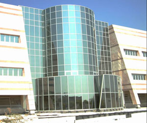
Ono Academic College
Distance: Approx. 923 meters
Latitude and longitude: 32.04919722,34.86205556
Ono Academic College (in Hebrew: הקריה האקדמית אונו) is a private college located in Kiryat Ono, Israel with over 18,000 students.

Ganei Tikva
City in Israel
Distance: Approx. 1807 meters
Latitude and longitude: 32.06111111,34.87444444
Ganei Tikva (Hebrew: גַּנֵּי תִּקְוָה, lit. '"gardens of hope"') is a city in Israel bordering Kiryat Ono to the west, Petah Tikva to the north, Gat Rimon to the east and Savyon to the south.

Wohl Centre
Distance: Approx. 1957 meters
Latitude and longitude: 32.07148079,34.84669176
The Wohl Centre is a convention center on the main campus of Bar-Ilan University in Ramat-Gan, Israel.

Kfar Azar
Neighborhood of Ramat Gan in Ramat Gan, Israel
Distance: Approx. 2111 meters
Latitude and longitude: 32.065,34.83666667
Kfar Azar (Hebrew: כְּפַר אֲזָ"ר) is a moshav ovdim located in the Ono Valley in central Israel. Previously part of Ef'al Regional Council, in 2007 it was transferred to the municipality of Ramat Gan together with Ramat Ef'al. With an area of around 1,000 acres (4.0 km2), its population is around 500.
Weather in this IP's area
scattered clouds
25 Celsius
26 Celsius
24 Celsius
26 Celsius
1012 hPa
65 %
1012 hPa
1005 hPa
10000 meters
1.54 m/s
40 %
06:25:14
18:45:41