Country:
 USA
USARegion:
City:
Latitude and Longitude:
Time Zone:
Postal Code:
IP information under different IP Channel
ip-api
Country
Region
City
ASN
Time Zone
ISP
Blacklist
Proxy
Latitude
Longitude
Postal
Route
IPinfo
Country
Region
City
ASN
Time Zone
ISP
Blacklist
Proxy
Latitude
Longitude
Postal
Route
MaxMind
Country
Region
City
ASN
Time Zone
ISP
Blacklist
Proxy
Latitude
Longitude
Postal
Route
Luminati
Country
USASN
Time Zone
America/Chicago
ISP
USINTERNET
Latitude
Longitude
Postal
db-ip
Country
Region
City
ASN
Time Zone
ISP
Blacklist
Proxy
Latitude
Longitude
Postal
Route
ipdata
Country
Region
City
ASN
Time Zone
ISP
Blacklist
Proxy
Latitude
Longitude
Postal
Route
Popular places and events near this IP address

Minnetonka, Minnesota
City in Minnesota, United States
Distance: Approx. 3743 meters
Latitude and longitude: 44.91333333,-93.50333333
Minnetonka ( MIN-i-TONG-kə) is a city in Hennepin County, Minnesota, United States. A western suburb of the Twin Cities, Minnetonka is located about 10 miles (16 km) west of downtown Minneapolis. At the 2020 census, the city's population was 53,781.
Woodland, Minnesota
City in Minnesota, United States
Distance: Approx. 3730 meters
Latitude and longitude: 44.95166667,-93.50888889
Woodland is a community in Hennepin County, Minnesota, United States, with lake shore property on Lake Minnetonka. The population was 437 at the 2010 census. The first settlers arrived in 1857, when Woodland was part of Minnetonka Township.
Minnetonka High School
Public school in Minnetonka, Minnesota, United States
Distance: Approx. 4527 meters
Latitude and longitude: 44.9090907,-93.511296
Minnetonka High School, or MHS (locally referred to as Tonka or Tonka High), is a four-year public high school in Minnetonka, Minnesota, United States, a western suburb of Minneapolis-St. Paul. The school enrolls about 3,540 students, and offers four interchangeable academic curricula: International Baccalaureate, Advanced Placement, Honors, and G (general).
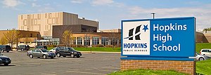
Hopkins High School
Public school in Minnetonka, Minnesota, United States
Distance: Approx. 4963 meters
Latitude and longitude: 44.9575604,-93.4128477
Hopkins High School is a public high school located in Minnetonka, Minnesota, United States. Hopkins High School is part of the Hopkins School District 270.

Ridgedale Center
Shopping mall in Minnesota, United States
Distance: Approx. 4309 meters
Latitude and longitude: 44.968,-93.438
Ridgedale Center, colloquially known as Ridgedale, is an enclosed shopping mall in Minnetonka, Minnesota, a western suburb of the Twin Cities. It is directly located off I-394/US 12 between Ridgedale Drive and Plymouth Road (Hennepin CSAH 61). Ridgedale Center comprises 1,105,337 square feet (100,000 m2) of leaseable retail space, and contains approximately 140 retail tenants.

Minnehaha Creek Watershed District
Hennipen County Minnesota drainage basin
Distance: Approx. 582 meters
Latitude and longitude: 44.93833333,-93.47361111
The Minnehaha Creek Watershed District is a watershed district in Minnesota with a mission to collaborate with public and private partners to protect and improve land and water for current and future generations. The Minnehaha Creek in its name refers to the water link from Lake Minnetonka to the Mississippi River. The watershed is much larger than a lake or creek, and includes 29 communities, and encompasses 178 square miles (460 km2).

Charles H. Burwell House
Historic house in Minnesota, United States
Distance: Approx. 1671 meters
Latitude and longitude: 44.94138889,-93.44805556
The Charles H. Burwell House is a historic house museum in Minnetonka, Minnesota, United States, built in 1883. Charles H. Burwell (1838–1917) was the secretary and manager of the Minnetonka Mills Company, the first mill west of Minneapolis, around which grew the first permanent Euro-American settlement in Hennepin County west of Minneapolis. This property on Minnehaha Creek, including the house and two outbuildings, is listed on the National Register of Historic Places for its Carpenter Gothic/Stick style architecture and association with Minnetonka's early milling history.

Glen Lake Sanatorium
Distance: Approx. 4724 meters
Latitude and longitude: 44.8930191,-93.4643973
Glen Lake Sanatorium, a tuberculosis treatment center serving Hennepin County in Minnesota, opened on January 4, 1916, with a capacity of 50 patients, and closed in 1976. In 1909, the Minnesota State Legislature had passed a bill authorizing the appointment of county sanatorium boards and appropriating money for the construction of county sanatoriums. Glen Lake Sanatorium was the fifth of fourteen county sanatoria that opened in Minnesota between 1912 and 1918.

Hopkins Library
Building in Hopkins, Minnesota
Distance: Approx. 4344 meters
Latitude and longitude: 44.92555556,-93.41416667
Library service to the Hopkins, Minnesota community was established more than 100 years ago, when the library was housed in City Hall. The library moved to the historic Dow House in 1948 and then temporarily to a vacant restaurant in 1963. The library opened in its current location in 1968 and was renovated in 2002.
Wayzata Bay Center
Shopping mall in Minnesota, US
Distance: Approx. 4811 meters
Latitude and longitude: 44.96888889,-93.50611111
Wayzata Bay Center was an enclosed shopping mall in Wayzata, Minnesota, a suburb of the Twin Cities. Wayzata Bay Center once comprised 127,000 square feet (12,000 m2) of retail space, with approximately 30 stores on one level, but closed in 2011 after the city of Wayzata agreed to construction of a new facility on the property. The mall was once owned by Madison Marquette until residents of the city purchased the mall for $16 million in December 2004.
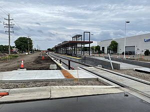
Downtown Hopkins station
Minnesota light rail station, under construction
Distance: Approx. 4887 meters
Latitude and longitude: 44.921352,-93.408754
Downtown Hopkins station is under construction light rail station in Hopkins, Minnesota on the Southwest LRT extension of the Green Line. The station, one of three located in Hopkins, is located just adjacent to Excelsior Blvd or Hennepin County Road 3. Downtown Hopkins is about a five-minute walk away or .25 miles (0.40 km).

Hopkins Commercial Historic District
United States historic place
Distance: Approx. 4586 meters
Latitude and longitude: 44.92436,-93.41144
The Hopkins Commercial Historic District covers 2.5 blocks of Main Street in downtown Hopkins, Minnesota. The district was significant regional destination for agricultural, industrial, and commercial activity. Areas around Hopkins historically produced many raspberries and local industrial activity eventually contributed to Minneapolis-Moline which manufactured industrial machinery.
Weather in this IP's area
clear sky
18 Celsius
17 Celsius
17 Celsius
19 Celsius
1019 hPa
39 %
1019 hPa
985 hPa
10000 meters
7.72 m/s
180 degree
07:33:53
18:23:36