Country:
Region:
City:
Latitude and Longitude:
Time Zone:
Postal Code:
IP information under different IP Channel
ip-api
Country
Region
City
ASN
Time Zone
ISP
Blacklist
Proxy
Latitude
Longitude
Postal
Route
Luminati
Country
ASN
Time Zone
Europe/Paris
ISP
Societe Francaise Du Radiotelephone - SFR SA
Latitude
Longitude
Postal
IPinfo
Country
Region
City
ASN
Time Zone
ISP
Blacklist
Proxy
Latitude
Longitude
Postal
Route
db-ip
Country
Region
City
ASN
Time Zone
ISP
Blacklist
Proxy
Latitude
Longitude
Postal
Route
ipdata
Country
Region
City
ASN
Time Zone
ISP
Blacklist
Proxy
Latitude
Longitude
Postal
Route
Popular places and events near this IP address

EFREI
Private engineering school of Paris-Panthéon-Assas University
Distance: Approx. 114 meters
Latitude and longitude: 48.78972222,2.36388889
The EFREI (École d'ingénieur généraliste en informatique et technologies du numérique) (Engineering School of Information and Digital Technologies) is the private engineering school of Paris-Panthéon-Assas University, located in Villejuif, Île-de-France, at the south of Paris. Its courses, specializing in computer science and management, are taught with support from the state. Students who graduate earn an engineering degree accredited by the CTI (national commission for engineering degree accreditation) and the French government.

Villejuif
Commune in Île-de-France, France
Distance: Approx. 356 meters
Latitude and longitude: 48.7919,2.3636
Villejuif (French pronunciation: [vilʒɥif] ) is a commune in the southern suburbs of Paris, France. It is located 7 km (4.3 mi) from the centre of Paris.

Villejuif–Louis Aragon station
Metro station in Paris, France
Distance: Approx. 328 meters
Latitude and longitude: 48.787175,2.367564
Villejuif–Louis Aragon station (French pronunciation: [vilʒɥif lwi aʁaɡɔ̃]) is a station of the Paris Métro, located in the commune of Villejuif.

Villejuif–Paul Vaillant-Couturier station
Metro station in Paris, France
Distance: Approx. 877 meters
Latitude and longitude: 48.795991,2.368248
Villejuif–Paul Vaillant-Couturier (French pronunciation: [vilʒɥif pɔl vajɑ̃ kutyʁje]) is a station of the Paris Métro, located on Line 7. It serves the commune of Villejuif.

Hôpital Paul-Brousse
Hospital in Val-de-Marne, France
Distance: Approx. 808 meters
Latitude and longitude: 48.79583333,2.36166667
Hôpital Paul-Brousse is a hospital in Villejuif, Val-de-Marne, France. It is named after Paul Brousse, a French socialist. Marc Zelter MD and Daniel Vittecoq MD were professors in this hospital.

Institut Gustave Roussy
Hospital in Villejuif, France
Distance: Approx. 1296 meters
Latitude and longitude: 48.79472222,2.34861111
Institut Gustave Roussy, sometimes called Gustave Roussy, is a cancer research hospital in Europe. It is located near Paris. It is named after Gustave Roussy, a Swiss-French neuropathologist.

Institut Sup'Biotech de Paris
Distance: Approx. 1129 meters
Latitude and longitude: 48.79805556,2.35777778
The Institut SupBiotech de Paris (SupBiotech or ISBP; English: Paris Higher Biotechnology Institute) is a French private engineering school created in 2003, located in Villejuif, near Paris, and in Lyon. SupBiotech is specialized in the field of biotechnology. The school delivers a 5-year program split in two parts: the first three years correspond to a bachelor's degree in biotechnology and the last three years to a French engineering degree (academically equivalent to a master's degree) in biotechnology.
Sid Ahmed Ghlam case
2015 murder of Aurélie Châtelain and planning of an Islamic terrorist attack in France
Distance: Approx. 1573 meters
Latitude and longitude: 48.7975,2.34694444
The Sid Ahmed Ghlam case (French: Affaire Sid Ahmed Ghlam) concerns the April 2015 murder of Aurélie Châtelain and planning of an Islamic terrorist attack against a church in Villejuif, France, by an Algerian national, Sid Ahmed Ghlam. In November 2020, he was sentenced to life in prison by a Paris court. This sentence was upheld on appeal in October 2021.
Canton of Villejuif
Distance: Approx. 309 meters
Latitude and longitude: 48.79,2.36
The canton of Villejuif is an administrative division of the Val-de-Marne department, Île-de-France region, northern France. It was created at the French canton reorganisation which came into effect in March 2015. Its seat is in Villejuif.

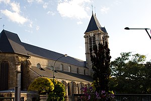
Church of Saint-Cyr-Sainte-Julitte, Villejuif
Roman Catholic church in Villejuif, Val-de-Marne, France
Distance: Approx. 392 meters
Latitude and longitude: 48.79222222,2.36361111
The Church of Saint-Cyr-Sainte-Julitte (French: église Saint-Cyr-Sainte-Julitte) is a Roman Catholic church located in Villejuif, Val-de-Marne, France. It is listed as a Historic Monument.

Hôtel de la Capitainerie des Chasses
Historic Monument in Villejuif, France
Distance: Approx. 447 meters
Latitude and longitude: 48.79222222,2.36666667
The Hôtel de la Capitainerie des Chasses (lit. 'Hunting Master's Office Hotel') is a hôtel particulier and Historic Monument in Villejuif in the Val-de-Marne department, France.

Villejuif–Gustave Roussy station
Future Paris Métro station in Villejuif
Distance: Approx. 1178 meters
Latitude and longitude: 48.7933,2.34926
Villejuif–Gustave Roussy station is an upcoming underground station on Line 14 and Line 15 of the Paris Métro. It is part of the Grand Paris Express project. The station is located in the town of Villejuif near the Institut Gustave Roussy.
Weather in this IP's area
broken clouds
8 Celsius
6 Celsius
7 Celsius
9 Celsius
1018 hPa
93 %
1018 hPa
1005 hPa
7000 meters
3.09 m/s
240 degree
75 %
08:03:01
17:08:25