Country:
Region:
City:
Latitude and Longitude:
Time Zone:
Postal Code:
IP information under different IP Channel
ip-api
Country
Region
City
ASN
Time Zone
ISP
Blacklist
Proxy
Latitude
Longitude
Postal
Route
Luminati
Country
Region
nv
City
lasvegas
ASN
Time Zone
America/Los_Angeles
ISP
DOE-NTS-AS
Latitude
Longitude
Postal
IPinfo
Country
Region
City
ASN
Time Zone
ISP
Blacklist
Proxy
Latitude
Longitude
Postal
Route
db-ip
Country
Region
City
ASN
Time Zone
ISP
Blacklist
Proxy
Latitude
Longitude
Postal
Route
ipdata
Country
Region
City
ASN
Time Zone
ISP
Blacklist
Proxy
Latitude
Longitude
Postal
Route
Popular places and events near this IP address

Las Vegas
Largest city in Nevada, United States
Distance: Approx. 1442 meters
Latitude and longitude: 36.175,-115.13638889
Las Vegas, often known simply as Vegas, is the most populous city in the U.S. state of Nevada and the seat of Clark County. The Las Vegas Valley metropolitan area is the largest within the greater Mojave Desert, and second-largest in the Southwestern United States. Las Vegas is an internationally renowned major resort city, known primarily for its gambling, shopping, fine dining, entertainment, and nightlife, with most venues centered on downtown Las Vegas and more to the Las Vegas Strip just outside city limits.

Roman Catholic Archdiocese of Las Vegas
Latin Catholic ecclesiastical jurisdiction in Nevada, USA
Distance: Approx. 1442 meters
Latitude and longitude: 36.175,-115.13638889
The Archdiocese of Las Vegas (Latin: Archidiœcesis Campensis) is a Latin Church ecclesiastical territory, or archdiocese, of the Catholic Church in southern Nevada, United States. The seat of the archdiocese is Guardian Angel Cathedral in Las Vegas. The see had been a suffragan diocese of the Archdiocese of San Francisco from its creation in 1995 until 2023, when Las Vegas was elevated as a metropolitan see.

Old Las Vegas Mormon Fort State Historic Park
State park in Nevada, U.S.
Distance: Approx. 776 meters
Latitude and longitude: 36.18055556,-115.13361111
Old Las Vegas Mormon Fort State Historic Park is a state park of Nevada. It contains the Old Mormon Fort (completed 1855), the first permanent structure built in what would become Las Vegas fifty years later. In present-day Las Vegas, the site is at the southeast corner of Las Vegas Boulevard and Washington Avenue, less than one mile north of the downtown area and Fremont Street.
North Vista Hospital
Hospital in Nevada, United States
Distance: Approx. 1138 meters
Latitude and longitude: 36.19487,-115.12262
North Vista Hospital is a for-profit hospital owned and operated by Prime Healthcare Services and is the only acute care hospital in North Las Vegas, Nevada. The hospital provides 201 beds.

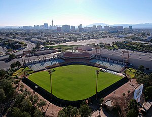
Cashman Field
Stadium in Las Vegas, Nevada
Distance: Approx. 844 meters
Latitude and longitude: 36.17966667,-115.12997222
Cashman Field is a stadium in Downtown Las Vegas, Nevada, United States. It is primarily used for soccer as the home field of Las Vegas Lights FC of the USL Championship. Originally built as a baseball stadium, it was the home of the Triple-A Las Vegas Stars/51s Minor League Baseball from 1983 to 2018, and home to the Vegas Vipers of the XFL in 2023.

Woodlawn Cemetery (Las Vegas)
United States historic place
Distance: Approx. 145 meters
Latitude and longitude: 36.1874,-115.1294
Woodlawn cemetery, consisting of 40 acres (16 ha), is a cemetery located in Las Vegas, Nevada that is listed on the United States National Register of Historic Places. It is owned by the City of Las Vegas and is a stop on the city's "Pioneer Trail". It houses the Veterans Circle that commemorates the service and sacrifice of Nevada veterans.

Washington School (North Las Vegas, Nevada)
United States historic place
Distance: Approx. 931 meters
Latitude and longitude: 36.1955,-115.13231
Washington School is a school listed on the National Register of Historic Places in Nevada and is located at 1901 N. White Street in the city of North Las Vegas. The school was open and operated by the Clark County School District until early 2016 when it closed due to budget cuts.

Rancho High School
Public high school in North Las Vegas, Nevada
Distance: Approx. 785 meters
Latitude and longitude: 36.18555556,-115.1225
Rancho High School is a high school in North Las Vegas, Nevada, within the Clark County School District. The school opened in 1953 as the third public high school in the Las Vegas Valley, following Las Vegas High School (founded in 1905) and Basic High School (founded in 1942). Fifty years later, the original campus was torn down in June 2006 and students moved into a new campus, constructed on the site of the original campus' football field, in July 2006, with all construction finishing the following year.
Silver Nugget
Casino and arena in Nevada, United States
Distance: Approx. 1416 meters
Latitude and longitude: 36.1986,-115.124
The Silver Nugget is a casino and arena located on Las Vegas Boulevard North in North Las Vegas, Nevada. The casino is owned and operated by Fifth Street Gaming. The casino site covers 14 acres (5.7 ha) and includes a 14,000 sq ft (1,300 m2) arena.
Cashman Center
Multiuse complex in Las Vegas, Nevada
Distance: Approx. 807 meters
Latitude and longitude: 36.179952,-115.131027
The Cashman Center or the Cashman Field Center is a 483,000 sq ft (44,900 m2) complex on a 55 acres (22 ha) site in Las Vegas, Nevada. Operated by the City of Las Vegas, it includes Cashman Field and a permanently closed 98,100 sq ft (9,110 m2) convention center. The center was mostly used for local events, but did host national events like the second 2008 Democratic presidential debate and the 2008-09 United States Bowling Congress Open Championships.

Las Vegas Natural History Museum
American nonprofit museum
Distance: Approx. 853 meters
Latitude and longitude: 36.1799,-115.1339
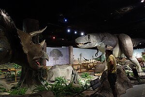
The Las Vegas Natural History Museum is a private, nonprofit natural history museum that is located in Downtown Las Vegas, Nevada. The exhibits focus on various subjects, from dinosaurs, marine life, and mammals both exotic and native, as well as an Egyptian exhibit that opened in February 2010, focusing on the life of Tutankhamen. The Museum opened on July 16, 1991, and is located on Las Vegas Boulevard across from the City of Las Vegas' Department of Human Resources, as part of the downtown area known as the Cultural Corridor.

Jerry's Nugget
Casino in Nevada, United States
Distance: Approx. 661 meters
Latitude and longitude: 36.193,-115.1326
Jerry's Nugget is a locals casino in North Las Vegas, Nevada. It was opened in 1964, by Jerry Lodge and his brother-in-law Jerry Stamis, and continues to be owned and operated by members of the Stamis family. In 1968, Jerry's Nugget moved down the street to its present location: a larger building which previously operated as the Bonanza Club from 1956 to 1967.
Weather in this IP's area
clear sky
10 Celsius
8 Celsius
8 Celsius
12 Celsius
1003 hPa
32 %
1003 hPa
937 hPa
10000 meters
2.57 m/s
190 degree
06:18:08
16:32:35