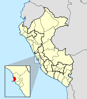
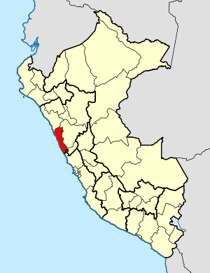
Country:
 Peru
PeruRegion:
City:
Latitude and Longitude:
Time Zone:
Postal Code:
IP information under different IP Channel
ip-api
Country
Region
City
ASN
Time Zone
ISP
Blacklist
Proxy
Latitude
Longitude
Postal
Route
IPinfo
Country
Region
City
ASN
Time Zone
ISP
Blacklist
Proxy
Latitude
Longitude
Postal
Route
MaxMind
Country
Region
City
ASN
Time Zone
ISP
Blacklist
Proxy
Latitude
Longitude
Postal
Route
Luminati
Country
PERegion
lma
City
lima
ASN
Time Zone
America/Lima
ISP
INTERNEXA PERU S.A
Latitude
Longitude
Postal
db-ip
Country
Region
City
ASN
Time Zone
ISP
Blacklist
Proxy
Latitude
Longitude
Postal
Route
ipdata
Country
Region
City
ASN
Time Zone
ISP
Blacklist
Proxy
Latitude
Longitude
Postal
Route
Popular places and events near this IP address

Jorge Chávez International Airport
Main airport serving Lima, Peru; located in Callao
Distance: Approx. 358 meters
Latitude and longitude: -12.02194444,-77.11444444
Jorge Chávez International Airport (IATA: LIM, ICAO: SPJC, SPIM) is the main international airport serving Lima, the capital of Peru. It is located in Callao, 11 kilometers (6.8 mi) northwest of Lima Center, the nation's capital city and 17 kilometers (11 mi) from the district of Miraflores. In 2023, the airport served 22,876,785 passengers.

San Martín de Porres District
District in Lima, Peru
Distance: Approx. 3796 meters
Latitude and longitude: -11.99388889,-77.09583333
San Martín de Porres (SMP) is a district in Lima, Peru, located in the north area of the city. It is bordered by the Chillón River, marks its natural border with Ventanilla and Puente Piedra on the north; Callao on the west; Los Olivos, Comas on the northeast; Rímac and Independencia districts on the east; the Rímac River marks its natural border with Lima District and Carmen de la Legua Reynoso on the south. It is the second most populated district of Lima metropolitan area and Peru.

Carmen de la Legua Reynoso District
District in Callao, Peru
Distance: Approx. 2496 meters
Latitude and longitude: -12.03944444,-77.09527778
Carmen de la Legua Reynoso District (Spanish: Distrito de Carmen de la Legua Reynoso) is a district of the Constitutional Province of Callao in Peru, and one of the seven districts that comprise the port city of Callao. In 1952 Carmen de la Legua Reynoso was founded by Lopez Pasos, Alejandro Ladron De Guevara, and Barios Medina. Antero Lizano, a pioneer of the city was elected the Organizational Secretary who established the zoning for Carmen de la Legua and distributed land to residents.

Blockade of Callao
Military operation during Salpeter War
Distance: Approx. 3702 meters
Latitude and longitude: -12.05,-77.13333333
The Blockade of Callao was a military operation that occurred during the War of the Pacific or the Salitre War and that consisted of the Chilean squadron preventing the entry of ships to the port of Callao and the neighboring coves between 10 April 1880 and 17 January 1881.
Roman Catholic Diocese of Callao
Roman Catholic diocese in Peru
Distance: Approx. 2535 meters
Latitude and longitude: -12.0333,-77.1333
The Roman Catholic Diocese of Callao (Latin: Callaën(sis)) is a diocese located in the city of Callao in the ecclesiastical province of Lima in Peru.
Roman Catholic Diocese of Chimbote
Roman Catholic diocese in Peru
Distance: Approx. 2535 meters
Latitude and longitude: -12.0333,-77.1333
The Roman Catholic Diocese of Chimbote (Latin: Cimbotien(sis)) is a diocese located in the city of Chimbote in the ecclesiastical province of Trujillo in Peru.
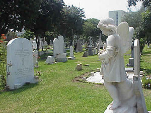
British Cemetery, Callao
Cemetery in Peru
Distance: Approx. 3791 meters
Latitude and longitude: -12.057,-77.121
The British Cemetery of Callao Peru is a cemetery used exclusively for burials of members of the British community in Peru. It has since been used for other expatriate nationalities.

First siege of Callao
Siege of the port of Callao in 1821 during the Peruvian War of Independence
Distance: Approx. 2540 meters
Latitude and longitude: -12.03333056,-77.13333056
The first siege of Callao was a prolonged military blockade of the Real Felipe Fortress (as well as other fortresses) in Callao by the Liberating Expedition of Peru under the command of General José de San Martín in July 1821 which culminated in the capitulation of Marshal José de La Mar in September of the same year, with him switching sides from the Royalist side to the Patriot side.

Second siege of Callao
Siege of the port of Callao from 1824 to 1826 during the Peruvian War of Independence
Distance: Approx. 2540 meters
Latitude and longitude: -12.03333056,-77.13333056
The second siege of Callao was the longest lasting siege that occurred on the Pacific coast during the Spanish American wars of independence. The siege was carried out by the combined Gran Colombian and Peruvian independence forces against the royalist soldiers defending the Real Felipe Fortress in the port of Callao, who refused to surrender, and refused to accept the capitulation of the Battle of Ayacucho. The siege took place from December 5, 1824 to January 23, 1826, when the royalist stronghold was defeated, ending the Spanish Empire's presence in South America.

Third siege of Callao
Siege of the port of Callao during the War of the Confederation
Distance: Approx. 2540 meters
Latitude and longitude: -12.03333056,-77.13333056
The third siege of Callao was a siege that took place in 1838 during the War of the Confederation between the United Restoration Army, supported by the Chilean army and the Peru–Bolivian Confederation. The confederates defeated the restorationist forces, who then retreated to Huacho due to the advance of the confederate army led by Andrés de Santa Cruz.

LATAM Airlines Perú Flight 2213
2022 aviation accident
Distance: Approx. 358 meters
Latitude and longitude: -12.02194444,-77.11444444
LATAM Airlines Perú Flight 2213 was a scheduled domestic passenger flight in Peru from Lima to Juliaca. On 18 November 2022, the Airbus A320neo was taking off from Jorge Chávez International Airport when it collided with a fire engine that was crossing the runway, killing two firefighters and injuring a third, who died of his injuries seven months later. Forty passengers were injured.

Callao Naval Base
Main naval base of the Peruvian Navy
Distance: Approx. 3102 meters
Latitude and longitude: -12.033,-77.139
Callao Naval Base (Spanish: Base Naval del Callao) is the main naval base of the Peruvian Navy. Located north of the main port of Callao, it is also a high-security prison, where members of terrorist groups such as the Shining Path and the Túpac Amaru Revolutionary Movement (MRTA) are located. The base hosts a dockyard and naval aviation base, as well as the Naval Medical Center, which contains the U.S. Navy's Naval Medical Research Unit Six.
Weather in this IP's area
overcast clouds
15 Celsius
15 Celsius
15 Celsius
16 Celsius
1011 hPa
88 %
1011 hPa
1007 hPa
8000 meters
2.57 m/s
220 degree
100 %
05:59:04
18:04:25