Country:
 Brazil
Region:
City:
Latitude and Longitude:
Time Zone:
Postal Code:
IP information under different IP Channel
ip-api
Country
Region
City
ASN
Time Zone
ISP
Blacklist
Proxy
Latitude
Longitude
Postal
Route
IPinfo
Country
Region
City
ASN
Time Zone
ISP
Blacklist
Proxy
Latitude
Longitude
Postal
Route
MaxMind
Country
Region
City
ASN
Time Zone
ISP
Blacklist
Proxy
Latitude
Longitude
Postal
Route
Luminati
Country
BRRegion
ap
City
macapa
ASN
Time Zone
America/Belem
ISP
VOCE TELECOMUNICACOES LTDA
Latitude
Longitude
Postal
db-ip
Country
Region
City
ASN
Time Zone
ISP
Blacklist
Proxy
Latitude
Longitude
Postal
Route
ipdata
Country
Region
City
ASN
Time Zone
ISP
Blacklist
Proxy
Latitude
Longitude
Postal
Route
Popular places and events near this IP address

Macapá
Capital city of Amapá, Brazil
Distance: Approx. 0 meters
Latitude and longitude: 0,-51.06638889
Macapá (Portuguese pronunciation: [makaˈpa] () is a city in Brazil with a population of 512,902 (2020 estimate), and is the capital of Amapá state in the country's North Region, located on the northern channel of the Amazon Delta near its mouth on the Atlantic Ocean. The city is on a small plateau on the Amazon in the southeast of the state of Amapá. The only access by road from outside the province is from the overseas French department of French Guiana, although there are regular ferries to Belém, Brazil.
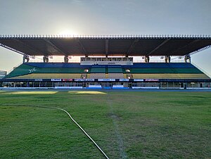
Zerão
Stadium in Macapá, Brazil
Distance: Approx. 4110 meters
Latitude and longitude: 0.00055556,-51.08083333
Estádio Olímpico Milton de Souza Corrêa (Portuguese pronunciation: [isˈtadʒu oˈlĩpiku ˈmiwtõ dʒi ˈsowzɐ koˈʁejjɐ]), commonly known as Zerão [zɛˈɾɐ̃w], is a multi-purpose stadium located in Macapá, Brazil. It is used mostly for football matches and hosts the home matches of Esporte Clube Macapá, Oratório Recreativo Clube, Trem Desportivo Clube, Santos Futebol Clube (AP) and São Paulo Futebol Clube (AP). The stadium has a maximum capacity of 13,680 people and was built in 1990.

Macapá International Airport
Airport
Distance: Approx. 2177 meters
Latitude and longitude: 0.05055556,-51.07222222
Macapá−Alberto Alcolumbre International Airport (IATA: MCP, ICAO: SBMQ) is the airport serving Macapá, Brazil. Since April 22, 2009 the airport is named after Alberto Alcolumbre, a local businessman. The airport is operated by Consortium Novo Norte.

Central Market of Macapá
Brazilian public market
Distance: Approx. 1119 meters
Latitude and longitude: 0.03083333,-51.05361111
The Central Market of Macapá (Portuguese: Mercado Central de Macapá) is a public market in the city of Macapá that was considered the shopping stronghold of the families of Amapá in the 1950s. Nowadays, the place still preserves some services such as the sales of vegetables and shoe repairs, along with snack bars, fishmongers, and butchers. The inauguration took place on September 13, 1953, an emblematic date since this was the anniversary of the creation of the Federal Territory of Amapá.
Weather in this IP's area
scattered clouds
34 Celsius
40 Celsius
34 Celsius
34 Celsius
1009 hPa
55 %
1009 hPa
1008 hPa
10000 meters
5.66 m/s
110 degree
40 %
06:15:44
18:22:23