Country:
Region:
City:
Latitude and Longitude:
Time Zone:
Postal Code:
IP information under different IP Channel
ip-api
Country
Region
City
ASN
Time Zone
ISP
Blacklist
Proxy
Latitude
Longitude
Postal
Route
Luminati
Country
Region
sp
City
praiagrande
ASN
Time Zone
America/Sao_Paulo
Latitude
Longitude
Postal
IPinfo
Country
Region
City
ASN
Time Zone
ISP
Blacklist
Proxy
Latitude
Longitude
Postal
Route
db-ip
Country
Region
City
ASN
Time Zone
ISP
Blacklist
Proxy
Latitude
Longitude
Postal
Route
ipdata
Country
Region
City
ASN
Time Zone
ISP
Blacklist
Proxy
Latitude
Longitude
Postal
Route
Popular places and events near this IP address

São Vicente, São Paulo
Municipality in São Paulo, Brazil
Distance: Approx. 4561 meters
Latitude and longitude: -23.96333333,-46.39222222
São Vicente (after Saint Vincent of Saragossa, the patron Saint of Lisbon, Portugal) is a coastal municipality in southern São Paulo, Brazil. It is part of the Metropolitan Region of Baixada Santista. The population is 329,911 (2022 est.) in an area of 148,151 square kilometres (57,201.42 square miles).
Captaincy of São Vicente
1534–1709 captaincy in southern Brazil
Distance: Approx. 6186 meters
Latitude and longitude: -23.95,-46.38333333
The Captaincy of São Vicente (1534–1709) was a land grant and colonial administration in the far southern part of the colonial Portuguese Empire in Colonial Brazil.

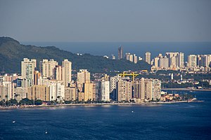
Praia Grande
Municipality in São Paulo, Brazil
Distance: Approx. 567 meters
Latitude and longitude: -24.00611111,-46.40277778
Praia Grande is a municipality in the Baixada Santista Metropolitan Region, on the southern coast of the Brazilian state of São Paulo. It is part of the Immediate Region of Santos and its population measured in the IBGE census review in 2010 was 262,051 inhabitants. In the 2022 IBGE census, the population of Praia Grande was 349,935 inhabitants, being the city in Baixada Santista that grew the most in the period 2010–2022.

Estádio Urbano Caldeira
Football stadium in Brazil
Distance: Approx. 8393 meters
Latitude and longitude: -23.95111111,-46.33888889
Estádio Urbano Caldeira, also known as Vila Belmiro, is an association football stadium located in the Vila Belmiro neighborhood of Santos, São Paulo, and the home of Santos Futebol Clube. The stadium was inaugurated on 12 October 1916, when Santos FC beat Clube Atlético Ypiranga 2–1, with Adolpho Millon Jr. scoring the first goal of the stadium.

Baixada Santista
Metropolitan area in São Paulo state
Distance: Approx. 8075 meters
Latitude and longitude: -23.96083333,-46.33388889
The Região Metropolitana da Baixada Santista is a metropolitan area located on the coast of São Paulo state in Brazil, with a population of 1.7 million. Its most populous city is Santos. As an administrative division (Região Metropolitana da Baixada Santista), it was created on 30 July 1996.
All Saints' Church, Santos
Distance: Approx. 6597 meters
Latitude and longitude: -23.96555556,-46.34833333
All Saints' Church is a Christian church of Anglican tradition, in the port city of Santos, in the state of São Paulo, Brazil, in April 1918. It was established as a chaplaincy of the Church of England, where its main function was to assist both the resident Anglican community and sailors of all nationalities who passed through the port. Currently, it's the only established church at Baixada Santista Metropolitan Region that is associated to Anglican Communion and is part of Anglican Diocese of The São Paulo, of Episcopal Anglican Church of the Brazil.

São Vicente Island (São Paulo, Brazil)
Island in Brazil
Distance: Approx. 7130 meters
Latitude and longitude: -23.95,-46.36
São Vicente Island (São Paulo, Brazil) (Ilha de São Vicente) is an island in São Paulo state, Brazil. It has an area of 57.4 km2 and a population of 760,000 people. The population density is 13,240/ km2, making it the most densely populated island in Brazil, and the 38th most densely populated island in the world.

Xixová-Japuí State Park
State park in São Paulo, Brazil
Distance: Approx. 683 meters
Latitude and longitude: -24.006111,-46.391389
The Xixová-Japuí State Park (Portuguese: Parque Estadual Xixová-Japuí) is a State park in the state of São Paulo, Brazil. It protects an isolated area of well-preserved Atlantic Forest on the Atlantic coast near the city of São Paulo.

São Vicente Suspension Bridge
Bridge in São Vicente
Distance: Approx. 3299 meters
Latitude and longitude: -23.97548889,-46.38884694
São Vicente Suspension Bridge (Portuguese: Ponte Pênsil de São Vicente) is a suspension bridge in São Vicente, São Paulo, Brazil. It was one of the first suspension bridges in Brazil, and carries vehicle and pedestrian traffic between Morro dos Barbosas and Japuí. Originally conceived in 1910 as a way to carry sewage away from the city of Santos and São Vicente, construction started in 1911, and the bridge opened in May 1914.

Basilica of St. Anthony, Santos
Church in Santos, Brazil
Distance: Approx. 8571 meters
Latitude and longitude: -23.97419444,-46.32
The Basilica of St. Anthony (Portuguese: Basílica Santo Antônio do Embaré) Also Basilica of Santos It is a Catholic church inaugurated in 1945 in the city of Santos, Sao Paulo in the south of Brazil, that was built in the style of neo-Gothic architecture. The basilica originates in the small chapel built in the middle of 1874 by Antonio Ferreira da Silva, then Baron de Embaré.

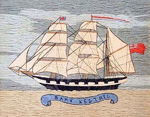
Kestrel (barque)
British clipper ship 1871–1895, wrecked on Santos Beach
Distance: Approx. 8702 meters
Latitude and longitude: -23.97888889,-46.31666667
The Kestrel was a British barque that was built in 1871 with coal-fueled steam engines and three masts. She spent her career carrying goods across the Atlantic. On 11 February 1895 she was anchored at Santos, near São Paulo, Brazil, when she was caught in a tropical storm.

Memorial Necrópole Ecumênica
Vertical cemetery in Brazil
Distance: Approx. 8289 meters
Latitude and longitude: -23.94836,-46.34355
The Memorial Necrópole Ecumênica is a Brazilian cemetery. Located in Santos, in the state of São Paulo, its construction began in 1983, and the first burial was on 28 July 1984. It was formally inaugurated on 20 September 1991.
Weather in this IP's area
scattered clouds
26 Celsius
26 Celsius
26 Celsius
26 Celsius
1013 hPa
91 %
1013 hPa
998 hPa
10000 meters
0.7 m/s
1.34 m/s
184 degree
27 %
05:15:48
18:22:42