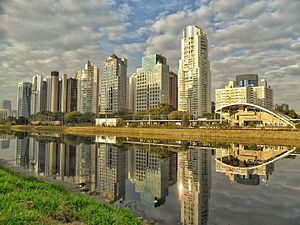
Country:
 Brazil
Region:
City:
Latitude and Longitude:
Time Zone:
Postal Code:
IP information under different IP Channel
ip-api
Country
Region
City
ASN
Time Zone
ISP
Blacklist
Proxy
Latitude
Longitude
Postal
Route
IPinfo
Country
Region
City
ASN
Time Zone
ISP
Blacklist
Proxy
Latitude
Longitude
Postal
Route
MaxMind
Country
Region
City
ASN
Time Zone
ISP
Blacklist
Proxy
Latitude
Longitude
Postal
Route
Luminati
Country
 AR
ARASN
Time Zone
America/Argentina/Buenos_Aires
ISP
TELXIUS TELXIUS Cable
Latitude
Longitude
Postal
db-ip
Country
Region
City
ASN
Time Zone
ISP
Blacklist
Proxy
Latitude
Longitude
Postal
Route
ipdata
Country
Region
City
ASN
Time Zone
ISP
Blacklist
Proxy
Latitude
Longitude
Postal
Route
Popular places and events near this IP address
Iguatemi São Paulo
Shopping mall in São Paulo, Brazil
Distance: Approx. 1077 meters
Latitude and longitude: -23.57700833,-46.68808056
The Iguatemi São Paulo shopping centre is the oldest Brazilian mall in operation. Located in the Brigadeiro Faria Lima Avenue, in the Jardins neighbourhood, the shopping mall was opened in November 28, 1966 (1966-11-28).
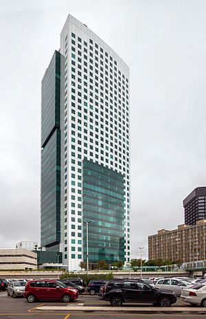
Eldorado Business Tower
Office in SP, Brazil
Distance: Approx. 719 meters
Latitude and longitude: -23.57305556,-46.69777778
Eldorado Business Tower is a 36-story skyscraper in São Paulo, Brazil. Completed in 2007, the 141 meters (462 feet) building is the 45th tallest building in South America, 17th in Brazil. The tower is located near Shopping Eldorado, a shopping center in Pinheiros.
Jardins
São Paulo region in Southeast, Brazil
Distance: Approx. 1474 meters
Latitude and longitude: -23.5725,-46.67916667
Jardins (Portuguese for Gardens) is the name given to an upper-class region of São Paulo city, which includes the neighbourhoods all comprised within the Subprefecture of Pinheiros: Jardim Paulista - in the Jardim Paulista district Jardim América - in the Jardim Paulista district Jardim Europa - in the Pinheiros district Jardim Paulistano - in the Pinheiros district Additionally, certain sections of Cerqueira César, located in the south area of Avenida Paulista are also considered as an integral part of the Jardins region. Jardins is limited by the following roads: Rebouças Avenue, River Pinheiros Marginal Avenue, Brigadeiro Luís Antônio Avenue and Paulista Avenue. It is considered one of the noblest areas of São Paulo.
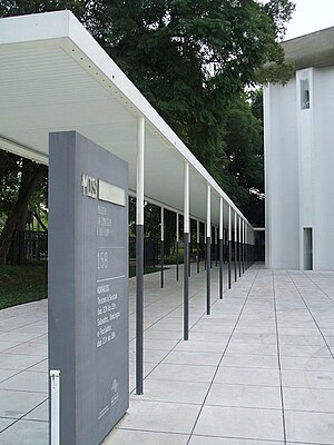
São Paulo Museum of Image and Sound
Distance: Approx. 1767 meters
Latitude and longitude: -23.5726,-46.6762
The São Paulo Museum of Image and Sound (in Portuguese, Museu da Imagem e do Som de São Paulo, or MIS) is a public museum of audio-visual works, established in 1970, and located in São Paulo, Brazil. The museum was founded as a result of a project conducted in the 1960s by Brazilian intellectuals, such as Ricardo Cravo Albin, Paulo Emílio Salles Gomes and Rudá de Andrade, with the purpose of endowing the country with institutions devoted to studying and documenting works of the new media that had been ignored by traditional museums. The museum is housed in a 5,000 square meters building in Pinheiros district, inaugurated in 1975.
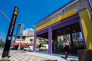
Fradique Coutinho (São Paulo Metro)
São Paulo Metro station
Distance: Approx. 927 meters
Latitude and longitude: -23.56611111,-46.68416667
Fradique Coutinho is a metro station on Line 4 (Yellow) of the São Paulo Metro operated by ViaQuatro. The station is located at Rua dos Pinheiros, 623 in the Pinheiros neighborhood. Although originally slated to open in 2010, the station was not inaugurated until 15 November 2014.

Faria Lima (São Paulo Metro)
São Paulo Metro station
Distance: Approx. 205 meters
Latitude and longitude: -23.5667702,-46.6938257
Faria Lima is a metro station on Line 4-Yellow of the São Paulo Metro operated by ViaQuatro. It is localized in Avenida Brigadeiro Faria Lima, between Rua Teodoro Sampaio and Rua Cardeal Arcoverde, in the district of Pinheiros. Had its civil construction concluded in February 2010.
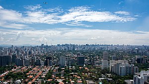
West Zone of São Paulo
Place in São Paulo, Brazil
Distance: Approx. 900 meters
Latitude and longitude: -23.57194444,-46.70083333
The West Zone is an Administrative Zone of São Paulo, Brazil.
Teatro Lira Paulistana
Distance: Approx. 1630 meters
Latitude and longitude: -23.5594,-46.6803
Teatro Lira Paulistana was a theatre in São Paulo, Brazil.

Conjunto Nacional (São Paulo)
Commercial centre in São Paulo, Brazil
Distance: Approx. 1075 meters
Latitude and longitude: -23.577,-46.6881
Conjunto Nacional is an important building and commercial centre of the city of São Paulo, Brazil. It occupies the block bounded by Avenida Paulista, Rua Augusta, Alameda Santos and Rua Padre João Manuel. The project was authored by architect David Libeskind and is characterized by being one of the first major modern multifunctional buildings deployed in the city of São Paulo.

Beco do Batman
Place in São Paulo, Brazil
Distance: Approx. 1469 meters
Latitude and longitude: -23.556541,-46.686587
Beco do Batman (English: Batman Alley) is the nickname for the area around Rua Gonçalo Afonso and Rua Medeiros de Albuquerque in the Vila Madalena neighborhood of São Paulo, Brazil. Beco do Batman is a popular tourist destination because of the dense concentration of graffiti that line the streets.

Largo da Batata
Distance: Approx. 259 meters
Latitude and longitude: -23.56638889,-46.69416667
Largo da Batata is a public square located in the district of Pinheiros, in the Brazilian city of São Paulo. It is located at the confluence of Brigadeiro Faria Lima Avenue and the streets Pinheiros, Teodoro Sampaio, Cardeal Arcoverde, Baltazar Carrasco, Martim Carrasco, Chopin Tavares de Lima and Fernão Dias. The Metro Line 4 Faria Lima Station and the Largo da Batata bus terminal (under construction) are located there.

Hebraica-Rebouças (CPTM)
Railway station in São Paulo, Brazil
Distance: Approx. 826 meters
Latitude and longitude: -23.5736821,-46.6985866
Hebraica-Rebouças is a train station on ViaMobilidade Line 9-Emerald, located in the district of Pinheiros in São Paulo. The station is located next to Eldorado Shopping Mall and the São Paulo A Hebraica club. It was built by CPTM and opened on 14 June 2000.
Weather in this IP's area
clear sky
25 Celsius
26 Celsius
22 Celsius
26 Celsius
1019 hPa
75 %
1019 hPa
936 hPa
8000 meters
2.06 m/s
80 degree
3 %
06:11:27
17:58:14