Country:
 Brazil
Region:
City:
Latitude and Longitude:
Time Zone:
Postal Code:
IP information under different IP Channel
ip-api
Country
Region
City
ASN
Time Zone
ISP
Blacklist
Proxy
Latitude
Longitude
Postal
Route
IPinfo
Country
Region
City
ASN
Time Zone
ISP
Blacklist
Proxy
Latitude
Longitude
Postal
Route
MaxMind
Country
Region
City
ASN
Time Zone
ISP
Blacklist
Proxy
Latitude
Longitude
Postal
Route
Luminati
Country
 AR
ARASN
Time Zone
America/Argentina/Buenos_Aires
ISP
TELXIUS TELXIUS Cable
Latitude
Longitude
Postal
db-ip
Country
Region
City
ASN
Time Zone
ISP
Blacklist
Proxy
Latitude
Longitude
Postal
Route
ipdata
Country
Region
City
ASN
Time Zone
ISP
Blacklist
Proxy
Latitude
Longitude
Postal
Route
Popular places and events near this IP address

Joelma Building fire
Skyscraper fire in Brazil in 1974
Distance: Approx. 374 meters
Latitude and longitude: -23.54944444,-46.64055556
Edifício Praça da Bandeira, formerly known as the Joelma Building, is a 25-story building in downtown São Paulo, Brazil, completed in 1971, located at Avenida 9 de Julho, 225. On 1 February 1974, an air conditioning unit on the twelfth floor overheated, starting a fire. Because flammable materials had been used to furnish the interior, the entire building was engulfed in flames within twenty minutes.

Edifício Itália
Skyscraper in Centre, São Paulo
Distance: Approx. 308 meters
Latitude and longitude: -23.54555556,-46.64361111
Edifício Itália (Portuguese for "Italy Building") (whose official name is Circolo Italiano) is a 165 m (541 ft) tall 46-story skyscraper located in the República district, Central Zone of São Paulo, Brazil. Built from 1956 to 1965, it has a rooftop observation deck, open for tourists. Edifício Itália was designed by Brazilian architect Franz Heep.

Teatro Cultura Artística
Distance: Approx. 224 meters
Latitude and longitude: -23.5493048,-46.645903
Since 1919, Sociedade de Cultura Artística nurtured the dream of having its own theatre in São Paulo, Brazil.
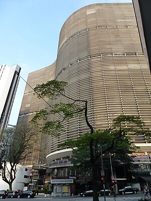
Edifício Copan
Skyscraper in São Paulo, Brazil
Distance: Approx. 191 meters
Latitude and longitude: -23.54661667,-46.644375
The Edifício Copan (Copan Building), or just Copan, is one of the most important and emblematic buildings in the city of São Paulo, located at number 200 Avenida Ipiranga, in the city center, and was inaugurated in 1966. It is one of the symbols of modern Brazilian architecture, designed by architect Oscar Niemeyer with structural design by engineer Joaquim Cardozo, aiming to celebrate the Fourth Centenary of the city of São Paulo. The work, however, only began in 1957, with some changes and carried out with the help of Carlos Lemos.
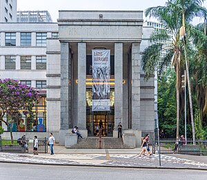
Mário de Andrade Library
Library in São Paulo, Brazil
Distance: Approx. 234 meters
Latitude and longitude: -23.5477,-46.6418
The Mário de Andrade Library (in Portuguese: Biblioteca Mário de Andrade; BMA) is the largest public library in the city of São Paulo, Brazil. Founded in 1925, with a donation of holdings by the library of the city's Câmara Municipal, it became one of the most important cultural institutions in Brazil, as well as one of the leading research libraries in the country. It is named in honor of Mário de Andrade, one of the founders of Brazilian modernism.

Municipal Chamber of São Paulo
Unicameral legislative body of São Paulo
Distance: Approx. 406 meters
Latitude and longitude: -23.5508,-46.6411
The Municipal Chamber of São Paulo is the unicameral legislative body of the city of São Paulo, it was created in 1560 by the Governor General Mem de Sá and is one of the oldest in Brazil.
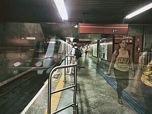
Anhangabaú (São Paulo Metro)
São Paulo Metro station
Distance: Approx. 477 meters
Latitude and longitude: -23.547917,-46.639345
Anhangabaú is a station on Line 3 (Red) of the São Paulo Metro.

Igreja Nossa Senhora da Consolação (São Paulo)
Catholic Temple in São Paulo, Brazil
Distance: Approx. 341 meters
Latitude and longitude: -23.5475,-46.64722222
Igreja Nossa Senhora da Consolação (English: Church of Our Lady of Consolation) is located in the Consolação neighborhood in the Brazilian city of São Paulo. It was founded in 1799 and reformed in 1840. The current building was designed by the German engineer Maximilian Emil Hehl and built between 1909 and 1959 at the location of the original temple.

Praça Roosevelt
Distance: Approx. 269 meters
Latitude and longitude: -23.5487,-46.6466
Praça Roosevelt is a public square in São Paulo, Brazil. Construction of the square began in 1968 and was completed in 1970. After decades of decline, the square was renovated in 2011–12.
Escola da Cidade
Private architecture school in Sao Paulo, Brazil
Distance: Approx. 404 meters
Latitude and longitude: -23.54486111,-46.64525
Escola da Cidade (lit. City School) is a private, not-for-profit institution of higher learning in São Paulo, Brazil. Established in 2001, it offers bachelor's degree and postgraduate programs in architecture and urban planning, as well as non-degree courses in architecture, urbanism, design, and related disciplines.

Jewish Museum of São Paulo
Jewish museum
Distance: Approx. 324 meters
Latitude and longitude: -23.5508,-46.64562
The Jewish Museum of São Paulo (Portuguese: Museu Judaico de São Paulo) is a Jewish museum in São Paulo, Brazil. It holds exhibits on Jewish life in Brazil and a collection of over 2,000 items brought over by immigrants to Brazil. The museum's building originated in 1928 as a Byzantine-style synagogue and was lent out to the museum in 2004.

Beth El Synagogue (São Paulo)
Synagogue in São Paulo
Distance: Approx. 323 meters
Latitude and longitude: -23.5508,-46.6456
Beth-El Synagogue (Portuguese: Sinagoga Beth-El) is a synagogue in the city of São Paulo, Brazil. Built in 1929, the synagogue has the distinction of being the first synagogue building in São Paulo. Consecrated in December 1929, construction of the temple was financed by a number of Jewish families in São Paulo and organized by Salomão Klabin.
Weather in this IP's area
clear sky
25 Celsius
26 Celsius
23 Celsius
26 Celsius
1019 hPa
73 %
1019 hPa
933 hPa
8000 meters
3.09 m/s
80 degree
4 %
06:11:15
17:58:02