Country:
 Chile
ChileRegion:
City:
Latitude and Longitude:
Time Zone:
Postal Code:
IP information under different IP Channel
ip-api
Country
Region
City
ASN
Time Zone
ISP
Blacklist
Proxy
Latitude
Longitude
Postal
Route
IPinfo
Country
Region
City
ASN
Time Zone
ISP
Blacklist
Proxy
Latitude
Longitude
Postal
Route
MaxMind
Country
Region
City
ASN
Time Zone
ISP
Blacklist
Proxy
Latitude
Longitude
Postal
Route
Luminati
Country
 AR
ARASN
Time Zone
America/Argentina/Buenos_Aires
ISP
TELXIUS TELXIUS Cable
Latitude
Longitude
Postal
db-ip
Country
Region
City
ASN
Time Zone
ISP
Blacklist
Proxy
Latitude
Longitude
Postal
Route
ipdata
Country
Region
City
ASN
Time Zone
ISP
Blacklist
Proxy
Latitude
Longitude
Postal
Route
Popular places and events near this IP address
San Joaquín
City and Commune in Santiago Metro., Chile
Distance: Approx. 936 meters
Latitude and longitude: -33.47915556,-70.64129722
San Joaquín (Spanish for Saint Joachim) is a commune of Chile located in Santiago Province, Santiago Metropolitan Region. It is part of Greater Santiago.
San Miguel, Chile
City and commune in Chile
Distance: Approx. 1654 meters
Latitude and longitude: -33.48583333,-70.64944444
San Miguel (Spanish for "Saint Michael") is a commune of Chile located in Santiago Province, Santiago Metropolitan Region. It was founded on August 10, 1896.
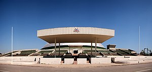
O'Higgins Park
Public park in Santiago, Chile
Distance: Approx. 1593 meters
Latitude and longitude: -33.46416667,-70.66
O'Higgins Park (Spanish: Parque O'Higgins, previously known as Parque Cousiño), covering approximately 75 hectares (190 acres), is Santiago, Chile's second largest public park after Metropolitan Park. It is situated in the center of the capital city, within the Santiago Commune. Named after Bernardo O'Higgins, one of Chile's founding fathers, the park is a popular destination for families on weekends and holidays, particularly during the national holiday on September 18, when traditional gathering places for dancing, eating, and drinking, called fondas and ramadas, are open to the public for a few days.

ONEMI
National emergency management agency of Chile
Distance: Approx. 1763 meters
Latitude and longitude: -33.46861111,-70.66388889
ONEMI or National Office of Emergency of the Interior Ministry (Spanish: Oficina Nacional de Emergencia del Ministerio del Interior) was a Chilean government agency dedicated to the prevention, organization, coordination and information relative to natural disasters. After the 1960 Valdivia earthquake a committee was formed to solve problems caused by the earthquake. However, this committee was not dissolved afterwards and in 1974, it acquired by law independent status as governmental office.
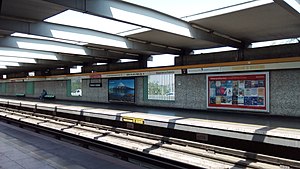
Parque O'Higgins metro station
Santiago metro station
Distance: Approx. 1528 meters
Latitude and longitude: -33.46164722,-70.65677222
Parque O'Higgins is a metro station on the Line 2 of the Santiago Metro, in Santiago, Chile. It is located in the middle of the east branch of the Autopista Central, on a raised embankment, just prior to an elevated viaduct that crosses Matta avenue. The station is named for the adjacent Parque O'Higgins, located west of the station.

Rondizzoni metro station
Santiago metro station
Distance: Approx. 1052 meters
Latitude and longitude: -33.46966389,-70.65633611
Rondizzoni is a metro station on the Line 2 of the Santiago Metro, in Santiago, Chile. It is located in the middle of a depressed alignment of Autopista Central and close to the southeast corner of O'Higgins Park. When the station opened, its name was Rondizzoni-Famae.

Franklin metro station
Santiago metro station
Distance: Approx. 628 meters
Latitude and longitude: -33.47582222,-70.64939167
Franklin is a transfer station between the Line 2 and Line 6 of the Santiago Metro. Their namesake is the Franklin Neighborhood. The Line 2 station was opened on 31 March 1978 as the southern terminus of the inaugural section of the line, from Los Héroes.
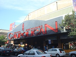
Teatro Caupolicán
Venue in Chile
Distance: Approx. 1731 meters
Latitude and longitude: -33.45621667,-70.64921111
Teatro Caupolicán (Caupolicán Theatre) is a theatre and music venue located on the San Diego street in Santiago, Chile. It was opened in 1936. During its long history has hosted sporting, political, and cultural events.

El Llano metro station
Santiago metro station
Distance: Approx. 1326 meters
Latitude and longitude: -33.48269444,-70.64975
El Llano is an underground metro station on the Line 2 of the Santiago Metro, in Santiago, Chile. The station was opened on 21 December 1978 as part of the extension of the line from Franklin to Lo Ovalle.

Bío Bío metro station
Santiago metro station
Distance: Approx. 655 meters
Latitude and longitude: -33.47672222,-70.64219444
Bío Bío is an underground metro station on the Line 6 of the Santiago Metro, in Santiago, Chile. This station is named for the station is located steps from the La Aguada Flood Park and the mentioned commercial district, one of the oldest in the city. The station was opened on 2 November 2017 as part of the inaugural section of the line, between Cerrillos and Los Leones.
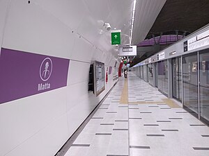
Matta metro station
Santiago metro station
Distance: Approx. 1499 meters
Latitude and longitude: -33.45805556,-70.64305556
Matta is an underground metro station of Line 3 of the Santiago Metro network, in Santiago, Chile. It is an underground, between the Parque Almagro and Irarrázaval stations on Line 3. It is located at the intersection of Matta Avenue with Santa Rosa Avenue.

Parque O'Higgins Circuit
Distance: Approx. 1673 meters
Latitude and longitude: -33.4625,-70.65972222
The Parque O'Higgins Circuit was an 11 turn, 2.287 km (1.421 mi) long temporary street circuit located in the city of Santiago, Chile, and was used for the Santiago ePrix of the electric, single-seater ABB Formula E Championship. Its first use came on 26 January 2019, when it hosted the 2019 Santiago ePrix, and replaced the previous Santiago Street Circuit as the venue of the race.
Weather in this IP's area
clear sky
16 Celsius
16 Celsius
14 Celsius
20 Celsius
1014 hPa
65 %
1014 hPa
952 hPa
10000 meters
2.57 m/s
140 degree
06:57:03
19:57:53