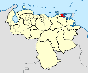
Country:
Region:
City:
Latitude and Longitude:
Time Zone:
Postal Code:
IP information under different IP Channel
ip-api
Country
Region
City
ASN
Time Zone
ISP
Blacklist
Proxy
Latitude
Longitude
Postal
Route
Luminati
Country
Region
l
ASN
Time Zone
America/Caracas
ISP
VIGINET C.A
Latitude
Longitude
Postal
IPinfo
Country
Region
City
ASN
Time Zone
ISP
Blacklist
Proxy
Latitude
Longitude
Postal
Route
db-ip
Country
Region
City
ASN
Time Zone
ISP
Blacklist
Proxy
Latitude
Longitude
Postal
Route
ipdata
Country
Region
City
ASN
Time Zone
ISP
Blacklist
Proxy
Latitude
Longitude
Postal
Route
Popular places and events near this IP address

Carúpano
Place in Sucre, Venezuela
Distance: Approx. 1683 meters
Latitude and longitude: 10.67222222,-63.24027778
Carúpano is a city in the eastern Venezuelan state of Sucre. It is located on the Venezuelan Caribbean coast at the opening of two valleys, some 120 km east of the capital of Sucre, Cumaná. This city is the shire town of the Bermúdez Municipality and, according to the 2010 Venezuelan census, the municipality has a population of 173,877 inhabitants.

Roman Catholic Diocese of Carúpano
Roman Catholic diocese in Venezuela
Distance: Approx. 636 meters
Latitude and longitude: 10.6648,-63.2481
The Roman Catholic Diocese of Carúpano (Latin: Dioecesis Carupaensis) is a diocese located in the city of Carúpano in the ecclesiastical province of Cumaná in Venezuela.
Weather in this IP's area
overcast clouds
31 Celsius
35 Celsius
31 Celsius
31 Celsius
1006 hPa
63 %
1006 hPa
1005 hPa
10000 meters
5.55 m/s
6.18 m/s
64 degree
92 %
06:08:25
17:46:51