Country:
Region:
City:
Latitude and Longitude:
Time Zone:
Postal Code:
IP information under different IP Channel
ip-api
Country
Region
City
ASN
Time Zone
ISP
Blacklist
Proxy
Latitude
Longitude
Postal
Route
Luminati
Country
IPinfo
Country
Region
City
ASN
Time Zone
ISP
Blacklist
Proxy
Latitude
Longitude
Postal
Route
db-ip
Country
Region
City
ASN
Time Zone
ISP
Blacklist
Proxy
Latitude
Longitude
Postal
Route
ipdata
Country
Region
City
ASN
Time Zone
ISP
Blacklist
Proxy
Latitude
Longitude
Postal
Route
Popular places and events near this IP address

Guarujá
Municipality in São Paulo, Brazil
Distance: Approx. 411 meters
Latitude and longitude: -23.99361111,-46.25638889
Guarujá (; Portuguese pronunciation: [ɡwaɾuˈʒa]) is a municipality in the São Paulo state of Brazil. It is part of the Metropolitan Region of Baixada Santista. The population is 311,116 (2022 preliminary census count) in an area of 143.58 km2 (55.44 sq mi).

Port of Santos
Container port in the city of Santos, São Paulo, Brazil
Distance: Approx. 4276 meters
Latitude and longitude: -23.98222778,-46.29260556
The Port of Santos (in Portuguese: Porto de Santos) is in the city of Santos, state of São Paulo, Brazil. As of 2006, it is the busiest container port in Latin America. In 2016, it was considered the 39th largest port in the world for container handling, and the 35th per ton, according to the AAPA - American Association of Port Authorities ranking, being the busiest in Latin America.
Estádio Municipal Antônio Fernandes
Distance: Approx. 1806 meters
Latitude and longitude: -23.99722222,-46.27111111
Estádio Municipal Antônio Fernandes, is a football stadium located in Guarujá, São Paulo, Brazil. It has a maximum capacity of 8,000 people. The stadium is owned by the Guarujá City Hall.
Catholic University of Santos
Private Catholic university in Santos, Brazil
Distance: Approx. 8499 meters
Latitude and longitude: -23.95,-46.32
The Catholic University of Santos (Portuguese: Universidade Católica de Santos, UniSantos or Católica de Santos) is a Brazilian private and non-profit Catholic university, located in Santos, São Paulo, the first university in the region of the city. It is one of the largest and most prestigious higher education institutions in Brazil, with many of its courses among the best ranked in the country, including Law, International Relations, Journalism, History, Psychology, Business Administration and Engineering. It is maintained by the Catholic Diocese of Santos.

2014 Santos Cessna Citation crash
Aircraft accident in Brazil
Distance: Approx. 8503 meters
Latitude and longitude: -23.9597,-46.3269
On 13 August 2014, a Cessna Citation Excel business jet crashed while trying to land at Santos Air Force Base, near Santos, Brazil, killing all seven people on board. Among the victims was Brazilian Socialist Party presidential candidate Eduardo Campos. Eleven people on the ground were also injured.

Basilica of St. Anthony, Santos
Church in Santos, Brazil
Distance: Approx. 7199 meters
Latitude and longitude: -23.97419444,-46.32
The Basilica of St. Anthony (Portuguese: Basílica Santo Antônio do Embaré) Also Basilica of Santos It is a Catholic church inaugurated in 1945 in the city of Santos, Sao Paulo in the south of Brazil, that was built in the style of neo-Gothic architecture. The basilica originates in the small chapel built in the middle of 1874 by Antonio Ferreira da Silva, then Baron de Embaré.
Ilha da Moela Lighthouse
Lighthouse
Distance: Approx. 6146 meters
Latitude and longitude: -24.05055556,-46.26333333
Ilha da Moela Lighthouse (Portuguese: Farol da Ilha da Moela) is an active lighthouse on the namesake island 1.84 kilometres (1.14 mi) from Ponta do Munduba at the entrance of Santos Bay, Brazil. Ilha da Moela Lighthouse is the oldest lighthouse on the State of São Paulo coast and the entire island is a Brazilian Navy base.

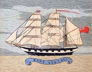
Kestrel (barque)
British clipper ship 1871–1895, wrecked on Santos Beach
Distance: Approx. 6714 meters
Latitude and longitude: -23.97888889,-46.31666667
The Kestrel was a British barque that was built in 1871 with coal-fueled steam engines and three masts. She spent her career carrying goods across the Atlantic. On 11 February 1895 she was anchored at Santos, near São Paulo, Brazil, when she was caught in a tropical storm.

Andradas Fort
Distance: Approx. 4341 meters
Latitude and longitude: -24.02333,-46.28396
The Andradas Fort (Portuguese: Forte dos Andradas, originally Portuguese: Forte do Monduba) is a fortification in the Morro do Monduba, at Guarujá, in the state of São Paulo in Brazil.

Pavilhão da Maria Fumaça
Tourist attraction in Guarujá, Brazil
Distance: Approx. 408 meters
Latitude and longitude: -23.995,-46.25722222
The Pavilhão da Maria Fumaça (Steam Train Pavilion) is a tourist attraction in Guarujá, Brazil. It houses the steam locomotive that took tourists from a station in the Itapema estuary to the front of the Grande Hotel on Pitangueiras beach. At the end of the 1910s, the branch on which the aforementioned steam locomotive - "Maria Fumaça" - was deactivated and a highway was built.

Santos-Dumont hearse pavilion
Tourist attraction in Guarujá, Brazil
Distance: Approx. 606 meters
Latitude and longitude: -23.99472222,-46.25916667
The Santos-Dumont hearse pavilion was a tourist attraction located in Guarujá, Brazil, which housed the 1929 Chevrolet Ramona that was the hearse that carried the body of the Brazilian aviator Alberto Santos-Dumont after he committed suicide at the Grand Hôtel La Plage, in Guarujá, on July 23, 1932.

Santos Air Force Base
Air base of the Brazilian Air Force
Distance: Approx. 8921 meters
Latitude and longitude: -23.92805556,-46.29972222
Santos Air Force Base – BAST (IATA: SSZ, ICAO: SBST) is a base of the Brazilian Air Force, located in Guarujá, Brazil. It will share some facilities with Guarujá Civil Metropolitan Aerodrome.
Weather in this IP's area
scattered clouds
22 Celsius
21 Celsius
22 Celsius
22 Celsius
1013 hPa
26 %
1013 hPa
1011 hPa
10000 meters
0.96 m/s
1.12 m/s
227 degree
25 %
05:15:14
18:22:06