Country:
 Chile
ChileRegion:
City:
Latitude and Longitude:
Time Zone:
Postal Code:
IP information under different IP Channel
ip-api
Country
Region
City
ASN
Time Zone
ISP
Blacklist
Proxy
Latitude
Longitude
Postal
Route
IPinfo
Country
Region
City
ASN
Time Zone
ISP
Blacklist
Proxy
Latitude
Longitude
Postal
Route
MaxMind
Country
Region
City
ASN
Time Zone
ISP
Blacklist
Proxy
Latitude
Longitude
Postal
Route
Luminati
Country
CLRegion
rm
City
providencia
ASN
Time Zone
America/Santiago
ISP
Manquehuenet
Latitude
Longitude
Postal
db-ip
Country
Region
City
ASN
Time Zone
ISP
Blacklist
Proxy
Latitude
Longitude
Postal
Route
ipdata
Country
Region
City
ASN
Time Zone
ISP
Blacklist
Proxy
Latitude
Longitude
Postal
Route
Popular places and events near this IP address

Providencia, Chile
Commune in the metropolitan region of Santiago, Chile
Distance: Approx. 907 meters
Latitude and longitude: -33.43333333,-70.61666667
Providencia (Spanish pronunciation: [pɾoβiˈðensja], Spanish: "providence") is a commune of Chile located in Santiago City. It is bordered by the communes of Santiago to the west, Recoleta to the northwest, Las Condes and Vitacura to the northeast, La Reina to the east, and Ñuñoa to the south. It belongs to the Northeastern zone of Santiago de Chile.

San Cristóbal Hill
Mountain in Santiago, Chile
Distance: Approx. 940 meters
Latitude and longitude: -33.425138,-70.632906
San Cristóbal Hill (Spanish: Cerro San Cristóbal, Mapuche: Tupahue) is a hill in northern Santiago, Chile. It rises 850 m AMSL and about 300 m above the rest of Santiago; the peak is the third highest point in the city, after Cerro Manquehue and Cerro Renca. Cerro San Cristóbal was named by the Spanish conquistadors for St Christopher, in recognition of its use as a landmark.

Balmaceda Park
Urban park in Providencia, Santiago, Chile
Distance: Approx. 917 meters
Latitude and longitude: -33.43432222,-70.62805
Balmaceda Park is an urban park along the Mapocho River in Providencia, Santiago de Chile. It was originally created under the name of Parque Japonés (Japanese Park) in 1930. When Chile joined the Allies during the World War II, its name was changed to Parque Gran Bretaña (Great Britain Park).
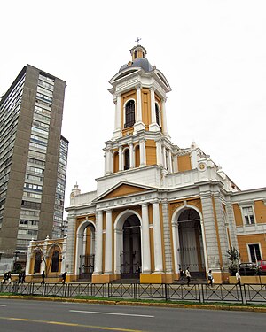
Iglesia de la Divina Providencia
Distance: Approx. 633 meters
Latitude and longitude: -33.42752222,-70.6163
The Iglesia de la Divina Providencia (English: Church of the Divine Providence) is a church managed by the Sisters of Providence, in Santiago, Chile. It gives its name to the district of Providencia and also to Avenida Providencia. The church was originally declared as a National Monument in 1975, but this designation was revoked and again designated as a national monument in 1989.
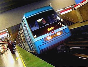
Salvador metro station
Santiago metro station
Distance: Approx. 668 meters
Latitude and longitude: -33.43265556,-70.62608611
Salvador is an underground metro station on the Line 1 of the Santiago Metro, in Santiago, Chile. The station is located beneath the Balmaceda Park and close to Salvador Avenue, which is named for the Hospital del Salvador. The station was opened on 31 March 1977 as the eastern terminus of the extension of the line from La Moneda.

Manuel Montt metro station
Santiago metro station
Distance: Approx. 341 meters
Latitude and longitude: -33.42856944,-70.61981111
Manuel Montt is an underground metro station on the Line 1 of the Santiago Metro, in Santiago, Chile. It was opened on 22 August 1980 as part of the metro extension from Salvador to Escuela Militar. Initially its walls were covered with stoneware ceramic tiles of blue and orange colors, some of which loosen or fall off as a consequence of the 2010 Chile earthquake.

Pedro de Valdivia metro station
Santiago metro station
Distance: Approx. 825 meters
Latitude and longitude: -33.42541944,-70.61448333
Pedro de Valdivia is an underground metro station on the Line 1 of the Santiago Metro, in Santiago, Chile. The station is named for the nearby Pedro de Valdivia Avenue, which in turn was named for Pedro de Valdivia. It was opened on 22 August 1980 as part of the extension of the line from Salvador to Escuela Militar.
Santiago Metropolitan Park
Urban park in Santiago, Chile
Distance: Approx. 960 meters
Latitude and longitude: -33.42361111,-70.6325
The Santiago Metropolitan Park is an urban park located within the city of Santiago, capital of Chile. Consisting of the San Cristóbal, Chacarillas and Los Gemelos hills, and the areas of Tupahue, Lo Saldés, Pirámide and Bosque Santiago, the park is located between four communes of Santiago – Huechuraba, Providencia, Recoleta and Vitacura – and covers around 722 hectares, making it the largest urban park of the Americas and one of the largest in the world. The Santiago Metropolitan Park also maintains 16 Urban Parks distributed throughout 13 communes in Santiago, a total area of almost 150.1 hectares.
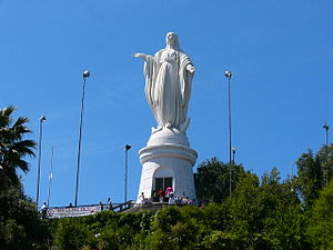
Sanctuary on San Cristóbal Hill
Distance: Approx. 962 meters
Latitude and longitude: -33.4253,-70.6332
The Sanctuary of the Immaculate Conception on San Cristóbal Hill is one of the principal places of worship for the Catholic Church of Chile, as well as being an icon of Santiago, Chile. It is notable in particular for a large statue of the Immaculate Conception, which is located at the summit of San Cristóbal Hill, some 863 meters above sea level.

Liceo José Victorino Lastarria (Santiago)
High school
Distance: Approx. 406 meters
Latitude and longitude: -33.4303,-70.6208
Liceo José Victorino Lastarria (English: José Victorino Lastarria High School) is a Chilean high school located in Santiago, Santiago Metropolitan Region, Chile. It was established in June 1913.
Radio Agricultura
Radio broadcasting network in Chile
Distance: Approx. 273 meters
Latitude and longitude: -33.42904,-70.62115
Radio Agricultura (originally Radio Sociedad Nacional de Agricultura) is a Chilean radio broadcasting network belonging to the association of landowners, Sociedad Nacional de Agricultura (SNA). It is run by Publicaciones y Difusión SA (which is owned by the SNA), the studios are at Edificio Pamplona. It was founded in 1935 in Valparaíso and inaugurated on October 30, 1936 in Santiago de Chile.
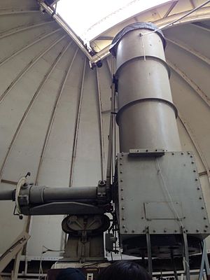
Manuel Foster Observatory
Observatory
Distance: Approx. 1034 meters
Latitude and longitude: -33.4221,-70.6324
The Observatorio Manuel Foster, or Manuel Foster Observatory, is an astronomical observatory constructed on Cerro San Cristóbal near Santiago, Chile in 1903. This site was originally known as the D. O. Mills Observatory after the philanthropist Darius Ogden Mills. It was built as an offshoot of the Lick Observatory to observe stars in the southern hemisphere, and, under the direction of the American astronomer W. W. Campbell, was used in an extensive project to determine the apex of the Sun's motion through space.
Weather in this IP's area
broken clouds
11 Celsius
10 Celsius
10 Celsius
13 Celsius
1015 hPa
59 %
1015 hPa
945 hPa
10000 meters
0.45 m/s
1.79 m/s
79 %
07:36:51
19:36:13