Country:
 Chile
ChileRegion:
City:
Latitude and Longitude:
Time Zone:
Postal Code:
IP information under different IP Channel
ip-api
Country
Region
City
ASN
Time Zone
ISP
Blacklist
Proxy
Latitude
Longitude
Postal
Route
IPinfo
Country
Region
City
ASN
Time Zone
ISP
Blacklist
Proxy
Latitude
Longitude
Postal
Route
MaxMind
Country
Region
City
ASN
Time Zone
ISP
Blacklist
Proxy
Latitude
Longitude
Postal
Route
Luminati
Country
CLRegion
bi
City
concepcion
ASN
Time Zone
America/Santiago
ISP
Pacifico Cable SPA.
Latitude
Longitude
Postal
db-ip
Country
Region
City
ASN
Time Zone
ISP
Blacklist
Proxy
Latitude
Longitude
Postal
Route
ipdata
Country
Region
City
ASN
Time Zone
ISP
Blacklist
Proxy
Latitude
Longitude
Postal
Route
Popular places and events near this IP address

Concepción, Chile
City and Commune in Bío Bío, Chile
Distance: Approx. 637 meters
Latitude and longitude: -36.82819444,-73.05136944
Concepción (Spanish pronunciation: [konseβˈsjon] ; originally: Concepción de la Madre Santísima de la Luz, "Conception of the Blessed Mother of Light") is a city and commune in south-central Chile, and the geographical and demographic core of the Greater Concepción metropolitan area, one of the three major conurbations in the country. It has a significant impact on domestic trade being part of the most heavily industrialized region in the country. It is the seat of the Concepción Province and the capital of the Bío Bío Region.

Biobío Region
Region of Chile
Distance: Approx. 117 meters
Latitude and longitude: -36.83333333,-73.05
The Biobío Region (Spanish: Región del Biobío [ˌbi.oˈβi.o]) is one of Chile's sixteen regions (first-order administrative divisions). With a population of 1.5 million, thus being the third most populated region in Chile, it is divided into three provinces: Arauco, Biobío and Concepción. The latter contains its capital and largest city, Concepción, a major city and metro area in the country.
Catholic University of the Most Holy Conception
University in Chile
Distance: Approx. 820 meters
Latitude and longitude: -36.82638889,-73.05111111
The Universidad Católica de la Santísima Concepción, translated into English as "Catholic University of the Most Immaculate Conception", is a private catholic university in Chile. It is part of the Chilean Traditional Universities.

University of Concepción
Chilean private university
Distance: Approx. 1173 meters
Latitude and longitude: -36.82833333,-73.03722222
Universidad de Concepción (UdeC) is a traditional Chilean private university. The work of the Penquista community, it is one of the most prestigious in its country, and considered complex due to its extensive research in the various areas of knowledge. Founded on May 14, 1919, it is the third oldest university in Chile, and one of the 25 universities belonging to the Council of Rectors of Chilean Universities.

Roman Catholic Archdiocese of Concepción
Catholic ecclesiastical territory
Distance: Approx. 699 meters
Latitude and longitude: -36.8276,-73.0514
The Roman Catholic Archdiocese of Concepción (Latin: Sanctissimae Conceptionis) is an archdiocese located in the city of Concepción in Chile.

Valle de la Mocha
Distance: Approx. 963 meters
Latitude and longitude: -36.825,-73.04666667
Valle de la Mocha ("the Valley of Mocha") is a plain in Chile on the north shore of the Bio-Bio River that contained the reducción of Mapuche who were transported in 1685, from Mocha Island by Governor José de Garro; from which the valley and plain took its name. Governor Domingo Ortiz de Rosas transferred the old city of Concepcion to this site from Penco after the May 25, 1751 Concepción earthquake.
Siege of Concepción
1564 siege
Distance: Approx. 117 meters
Latitude and longitude: -36.83333,-73.05
During the siege of Concepcion of the Arauco War, 20,000 warriors of the army of the Mapuche laid siege to the Spanish garrison and civil population in the fortress of Concepcion, Chile.
Presencia de América Latina
Mural by Jorge González Camarena in Concepción, Chile
Distance: Approx. 1100 meters
Latitude and longitude: -36.8275,-73.03888889
Presencia de América Latina (Presence of Latin America), also known as Integración de América Latina (Integration of Latin America), is a mural painted by Mexican artist Jorge González Camarena between November 1964 and April 1965. The 300-square-meter mural, painted in acrylics on rough stucco, is located in the lobby of the Casa del Arte of the University of Concepción (Ciudad Universitaria de Concepción), in Concepción, Chile. Its principal theme is the unity and brotherhood of the different Latin American cultures.
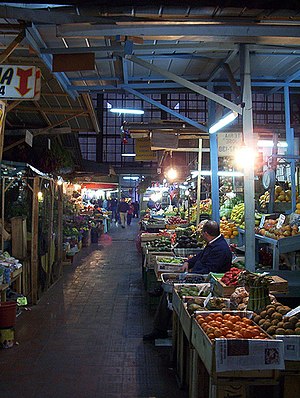
Central market of Concepción, Chile
Marketplace in Concepción, Chile
Distance: Approx. 956 meters
Latitude and longitude: -36.82555556,-73.05277778
The Central market of Concepción is a marketplace of fruits and vegetables with restaurants in the downtown area of Concepción. The area of the Central market is 3.600 m2. After the earthquake of Chillán on 1939, the Central market was designed on 1940 by the architects Tibor Weiner and Ricardo Mulle.
Casa del Arte
Art museum in Concepción, Chile
Distance: Approx. 1100 meters
Latitude and longitude: -36.8275,-73.03888889
The Casa del Arte José Clemente Orozco (more commonly known simply as the Casa del Arte, "House of Art" or Pinacoteco, "Art Gallery") is a Chilean art museum on the campus of the University of Concepción, in Concepción. It is situated on the corner of Chacabuco and Larenas, facing the Plaza Perú. The gallery attracts approximately 75,000 visitors a year and houses the country's largest collection of paintings outside the capital city of Santiago, and the most complete collection of Chilean art with some 1,800 works.
Plaza Perú (Concepción)
Distance: Approx. 1076 meters
Latitude and longitude: -36.8268,-73.04
Plaza Perú is a square in the city of Concepción, Chile. It is situated in the University District in front of the main entrance of the Ciudad Universitaria de Concepción, by the Arco Universidad de Concepción and adjacent to the Casa del Arte. Built in 1942, there are several historic buildings surrounding the square, which were built in the 1940s.

Lycée Français Charles de Gaulle (Chile)
Distance: Approx. 422 meters
Latitude and longitude: -36.8305,-73.0458
Lycée Français Charles de Gaulle is a French international school in Concepción, Chile. It serves primaire and secondaire levels. It was founded in the beginning of the year 1944 by the 'Comité Local de la France Libre' now known as the French National Committee founded by Charles de Gaulle.
Weather in this IP's area
broken clouds
11 Celsius
10 Celsius
11 Celsius
11 Celsius
1020 hPa
93 %
1020 hPa
1012 hPa
10000 meters
3.09 m/s
310 degree
75 %
07:45:25
19:46:19