Country:
 Chile
ChileRegion:
City:
Latitude and Longitude:
Time Zone:
Postal Code:
IP information under different IP Channel
ip-api
Country
Region
City
ASN
Time Zone
ISP
Blacklist
Proxy
Latitude
Longitude
Postal
Route
IPinfo
Country
Region
City
ASN
Time Zone
ISP
Blacklist
Proxy
Latitude
Longitude
Postal
Route
MaxMind
Country
Region
City
ASN
Time Zone
ISP
Blacklist
Proxy
Latitude
Longitude
Postal
Route
Luminati
Country
CLASN
Time Zone
America/Santiago
ISP
Telmex Chile Internet S.A.
Latitude
Longitude
Postal
db-ip
Country
Region
City
ASN
Time Zone
ISP
Blacklist
Proxy
Latitude
Longitude
Postal
Route
ipdata
Country
Region
City
ASN
Time Zone
ISP
Blacklist
Proxy
Latitude
Longitude
Postal
Route
Popular places and events near this IP address

Sanhattan
Major business district located in Santiago, Chile
Distance: Approx. 662 meters
Latitude and longitude: -33.41423611,-70.60492778
Sanhattan, a portmanteau of Santiago and Manhattan, is the popular ironic sobriquet given to Santiago's upscale financial district in Chile's capital. It is located to the northeast of the metropolis, in the western end of the Las Condes commune, nestled between the Mapocho River and Américo Vespucio avenue, encompassing the El Bosque Norte and El Golf barrios. A more narrow definition places it between the intersection of Andrés Bello and Vitacura avenues down to Nueva Los Leones avenue.
Costanera Center
Commercial and business complex in Chile
Distance: Approx. 763 meters
Latitude and longitude: -33.4175,-70.60666667
The Costanera Center is a commercial and business complex located in the commune of Providencia, Santiago, Chile. Owned by Cencosud, the complex consists of four skyscrapers, including the Gran Torre Santiago, two high-end hotels, an office building, and a six-floor shopping mall. The Gran Torre Santiago, which stands as the tallest of the four buildings, was designed by renowned architect César Pelli and measures 300 metres (980 ft) tall.
Santiago College
School in Santiago, Chile
Distance: Approx. 807 meters
Latitude and longitude: -33.423,-70.603
Fundación Educacional Santiago College is a private educational (PK-12) institution in Santiago, Chile, founded in 1880. It was founded by American Methodist Ira Haynes La Fetra and his wife as a girls boarding school. In March 1972 the school became co-ed.

Gran Torre Costanera
Tallest building in South America
Distance: Approx. 759 meters
Latitude and longitude: -33.41694444,-70.60666667
Gran Torre Costanera, previously known as Costanera Center Torre 2, and also known as El Costanera (The Costanera) by the locals, and previously known as Torre Gran Costanera, is a 62-story skyscraper in Santiago, Chile. It is the tallest building in South America, the second tallest building in Latin America (behind Mexico's T.Op Torre 1) and the fifth tallest building in the Southern Hemisphere (behind Indonesia's Autograph Tower and Luminary Tower, and Australia's Q1 Tower and Australia 108). The tower was designed by Chilean architects Alemparte Barreda & Asociados, the Argentine architect César Pelli and the Canadian company Watt International.

Titanium La Portada
Building in Santiago, Chile
Distance: Approx. 644 meters
Latitude and longitude: -33.41305556,-70.60377778
Titanium La Portada is an office building in Santiago, Chile. Located in the capital's high-end financial district of El Golf, it is the second tallest skyscraper in the country. Construction began in January 2007, and was completed in January 2010.
Ciudad del Niño Presidente Juan Antonio Ríos
Distance: Approx. 402 meters
Latitude and longitude: -33.41786,-70.60264
The Ciudad del Niño Presidente Juan Antonio Ríos (City of the Child President Juan Antonio Rios), known as Ciudad del Niño Presidente Ríos or only as a City of the Child was a shelter for abandoned children that was established by the Council for Defense of the Child on 23 December 1943 as a proposal of Minister of state and chairman of the Defense of Children Oscar Gajardo Villarroel, was a boarding school with, policlinico, theater, athletic fields, plazas and gardens similar to a city that only children, the proposal was sent to then-President Juan Antonio Rios and was accepted and sponsored by the First Lady Marta Ide Rios. The city was completed in 1943 and was named in honor of the President of Chile at that time not only for being the President if not for that by Provide support to create the Work, the work was supported by several countries that lent support in various Plena World War II as the United States, Britain, Venezuela, Canada, Brazil, Uruguay, Mexico, Ecuador, Colombia, Panama and Paraguay. Then in 1979 the late President Rivers precisely 33 years ago because the play did not have the same interest in the decades of the 1940s, 1950s and 1960s, and since mid-1990, the Council for Defense of the Child on Sename and decide to sell more land City and fail to manage as it did not support the internización of minors under the law of 2002.

Tobalaba metro station
Santiago metro station
Distance: Approx. 326 meters
Latitude and longitude: -33.41805556,-70.60166667
Tobalaba is a station on the Santiago Metro in Chile, the northern terminus of Line 4 and the closest station to the Costanera Center. The Line 1 station was opened on 22 August 1980 as part of the extension of the line from Salvador to Escuela Militar. It became an interchange station between Line 1 and Line 4 on 30 November 2005, when the section of Line 4 between Tobalaba and Grecia was opened, and the appearance of the station was altered.
Libertad y Desarrollo
Chilean free market think tank
Distance: Approx. 1004 meters
Latitude and longitude: -33.42,-70.5884
Libertad y Desarrollo, abbreviated to LyD, is a Chilean think tank focused on liberal, free market economic studies. Founded in 1990, the think tank defines itself as a "center for studies and private research, independent of any political, religious, business, or governmental organization, that is dedicated to the analysis of public affairs promoting the values and principles of a free society". The think tank is the Chilean representative of RELIAL, the Liberal Network of Latin America (Red Liberal de America Latina).

El Golf metro station
Santiago metro station
Distance: Approx. 287 meters
Latitude and longitude: -33.41653889,-70.59542222
El Golf is an underground metro station on the Line 1 of the Santiago Metro, in Santiago, Chile. It is located in El Golf neighborhood, close to the building that serves as the seat of local government for Las Condes. The station was opened on 22 August 1980 as part of the extension of the line from Salvador to Escuela Militar.
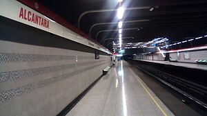
Alcántara metro station
Santiago metro station
Distance: Approx. 849 meters
Latitude and longitude: -33.41533889,-70.58952778
Alcántara is an underground metro station on the Line 1 of the Santiago Metro, in Santiago, Chile. The station was opened on 22 August 1980 as part of the extension of the line from Salvador to Escuela Militar.

Military Cathedral of Our Lady of Mount Carmel, Santiago
Church in Santiago, Chile
Distance: Approx. 820 meters
Latitude and longitude: -33.4204,-70.6062
The Military Cathedral of Our Lady of Mount Carmel (also Military Cathedral of Santiago; Spanish: Catedral Castrense de Nuestra Señora del Carmen) is a Catholic church that functions as the episcopal seat of the Military Bishopric of Chile. It is located in the commune of Providencia, in Santiago, the capital of Chile. The church is dedicated to the religious services of the Chilean Armed Forces and Carabineros, but it is also open to the rest of the community.
List of ambassadors of Romania to Chile
Distance: Approx. 510 meters
Latitude and longitude: -33.412607,-70.600722
The Romanian Ambassador in Santiago de Chile is the official representative of the Government in Bucharest to the Government of Chile.
Weather in this IP's area
overcast clouds
9 Celsius
9 Celsius
7 Celsius
10 Celsius
1017 hPa
82 %
1017 hPa
941 hPa
10000 meters
0.88 m/s
1.12 m/s
89 degree
100 %
07:33:58
19:37:26