190.171.118.230 - IP Lookup: Free IP Address Lookup, Postal Code Lookup, IP Location Lookup, IP ASN, Public IP
Country:
 Costa Rica
Region:
City:
Location:
Time Zone:
Postal Code:
ISP:
ASN:
language:
User-Agent:
Proxy IP:
Blacklist:
IP information under different IP Channel
ip-api
Country
Region
City
ASN
Time Zone
ISP
Blacklist
Proxy
Latitude
Longitude
Postal
Route
db-ip
Country
Region
City
ASN
Time Zone
ISP
Blacklist
Proxy
Latitude
Longitude
Postal
Route
IPinfo
Country
Region
City
ASN
Time Zone
ISP
Blacklist
Proxy
Latitude
Longitude
Postal
Route
IP2Location
190.171.118.230Country
crRegion
san jose
City
curridabat
Time Zone
America/Costa_Rica
ISP
Language
User-Agent
Latitude
Longitude
Postal
ipdata
Country
Region
City
ASN
Time Zone
ISP
Blacklist
Proxy
Latitude
Longitude
Postal
Route
Popular places and events near this IP address

Curridabat
District in Curridabat canton, San José province, Costa Rica
Distance: Approx. 476 meters
Latitude and longitude: 9.9160278,-84.0347619
Curridabat is a district of the Curridabat canton, in the San José province of Costa Rica.

San Pedro, Costa Rica
District in Montes de Oca canton, San José province, Costa Rica
Distance: Approx. 2767 meters
Latitude and longitude: 9.9331667,-84.0469973
San Pedro is a district of the Montes de Oca canton, in the San José province of Costa Rica.

Curridabat (canton)
Canton in San José province, Costa Rica
Distance: Approx. 814 meters
Latitude and longitude: 9.9163367,-84.0282798
Curridabat is the eighteenth canton in the San José province of Costa Rica. The head city the homonymous Curridabat. The canton forms a suburb of the national capital of San José, lying on the southeast edge of the city.
Zapote
District in San José canton, San José province, Costa Rica
Distance: Approx. 2915 meters
Latitude and longitude: 9.9203408,-84.0592286
Zapote the fifth district of the San José canton, in the San José province of Costa Rica. It is one of the administrative units surrounding San José downtown (officially composed of the districts of El Carmen, Merced, Hospital and Catedral). The district is primarily residential, although there are some government buildings, standing out the Presidential House, seat of the government.
San Francisco de Dos Ríos
District in San José canton, San José province, Costa Rica
Distance: Approx. 2668 meters
Latitude and longitude: 9.9082933,-84.0581714
San Francisco de Dos Ríos is the sixth district of the San José canton, in the San José province of Costa Rica. It is one of the administrative units surrounding San José downtown (officially composed by the districts of El Carmen, Merced, Hospital and Catedral). The district is primarily residential and industrial.

Tirrases
District in San José, Costa Rica
Distance: Approx. 1145 meters
Latitude and longitude: 9.9015151,-84.0340513
Tirrases is a district of the Curridabat canton, in the San José province of Costa Rica.
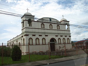
Parroquia San Antonio de Padua
Distance: Approx. 432 meters
Latitude and longitude: 9.91416667,-84.03722222
The Parroquia San Antonio de Padua, commonly known as the Iglesia de Curridabat is a church located in Curridabat, Costa Rica.

Jorge Hernán "Cuty" Monge Stadium
Costa Rican sports stadium
Distance: Approx. 2978 meters
Latitude and longitude: 9.88962,-84.04929
Jorge Hernán "Cuty" Monge Stadium is a football stadium in Desamparados, Costa Rica. It is the home ground of the La U Universitarios team.
San Antonio District, Desamparados
District in Desamparados canton, San José province, Costa Rica
Distance: Approx. 2009 meters
Latitude and longitude: 9.898993,-84.0470021
San Antonio is a district of the Desamparados canton, in the San José province of Costa Rica.
Damas District
District in Desamparados canton, San José province, Costa Rica
Distance: Approx. 2836 meters
Latitude and longitude: 9.8888666,-84.0453729
Damas is a district of the Desamparados canton, in the San José province of Costa Rica.
Granadilla District
District in Curridabat canton, San José province, Costa Rica
Distance: Approx. 2437 meters
Latitude and longitude: 9.9309202,-84.023276
Granadilla is a district of the Curridabat canton, in the San José province of Costa Rica.
Sánchez District
District in Curridabat canton, San José province, Costa Rica
Distance: Approx. 1906 meters
Latitude and longitude: 9.9130792,-84.0167642
Sánchez is a district of the Curridabat canton, in the San José province of Costa Rica.
Weather in this IP's area
clear sky
23 Celsius
23 Celsius
23 Celsius
24 Celsius
1013 hPa
62 %
1013 hPa
837 hPa
10000 meters
9.26 m/s
90 degree