Country:
 Chile
ChileRegion:
City:
Latitude and Longitude:
Time Zone:
Postal Code:
IP information under different IP Channel
ip-api
Country
Region
City
ASN
Time Zone
ISP
Blacklist
Proxy
Latitude
Longitude
Postal
Route
IPinfo
Country
Region
City
ASN
Time Zone
ISP
Blacklist
Proxy
Latitude
Longitude
Postal
Route
MaxMind
Country
Region
City
ASN
Time Zone
ISP
Blacklist
Proxy
Latitude
Longitude
Postal
Route
Luminati
Country
CLRegion
rm
City
santiago
ASN
Time Zone
America/Santiago
ISP
VTR BANDA ANCHA S.A.
Latitude
Longitude
Postal
db-ip
Country
Region
City
ASN
Time Zone
ISP
Blacklist
Proxy
Latitude
Longitude
Postal
Route
ipdata
Country
Region
City
ASN
Time Zone
ISP
Blacklist
Proxy
Latitude
Longitude
Postal
Route
Popular places and events near this IP address

Alberto Hurtado University
Jesuit university in Santiago
Distance: Approx. 590 meters
Latitude and longitude: -33.44481667,-70.66204444
Alberto Hurtado University (Spanish: Universidad Alberto Hurtado – UAH) is a Jesuit university located in Santiago, Chile. Established in 1997, the university was created from the merger of three separate institutes: Instituto Latinoamericano de Doctrina y Estudios Sociales (ILADES), the Centro de Investigación, Desarrollo de la Educación (CIDE), and the Fundación Educacional Roberto Bellarmino. The university is named after a famous Chilean Jesuit Saint, Father Alberto Hurtado.

Bolivarian University of Chile
Educational institution in Chile
Distance: Approx. 435 meters
Latitude and longitude: -33.440554,-70.661216
The Bolivarian University of Chile (Spanish: Universidad Bolivariana de Chile) is a Chilean university established in 1987. It has around 7000 students. The university obtained functional autonomy in 2002.
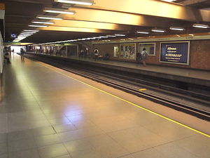
Santa Ana metro station
Santiago metro station
Distance: Approx. 617 meters
Latitude and longitude: -33.43805556,-70.66
Santa Ana is a transfer station between Line 2 and Line 5 of the Santiago Metro. It was initially a single-line station on Line 2, opened on 25 July 1986 as part of the extension of the line from Los Héroes to Puente Cal y Canto. Subsequently in 1998, the station began to be adapted to become a transfer station, as a part of the extension of Line 5 from Baquedano metro station to Santa Ana station, in which the New Austrian Tunnelling method was used.
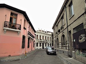
Barrio Concha y Toro
Distance: Approx. 554 meters
Latitude and longitude: -33.44557778,-70.66591667
Barrio Concha y Toro is a barrio in Santiago, Chile, with a medieval-like street plan influenced by the ideas of Camillo Sitte. The houses are built on the former site of the Díaz Gana Palace's park, which was divided into lots in 1915. The barrio's boundaries are defined by Brasil Avenue, Avenida Libertador General Bernardo O'Higgins, Cumming Avenue, Romero Street, Maturana Street and Erasmo Escala Street.
Colegio Alonso de Ercilla
High school in Cachapoal Province, Chile
Distance: Approx. 319 meters
Latitude and longitude: -33.4378,-70.66661
Colegio Alonso de Ercilla (English: Alonso de Ercilla School) is a Chilean high school located in Rancagua, Cachapoal Province, Chile.

Barrio Brasil
Neighbourhood in Santiago, Santiago Metro., Chile
Distance: Approx. 107 meters
Latitude and longitude: -33.44,-70.665
Barrio Brasil is a neighborhood of Santiago, Chile, located to the west of the city center in the commune of Santiago and to the east of Barrio Yungay. Barrio Brasil is close to the neighborhoods Dieciocho, Concha y Toro, Yungay, and República and lies immediately to the north of the Alameda. Barrio Brasil is known for its strong cultural and artistic scene, featuring a number of bars, nightclubs and cultural venues.

Galpón Víctor Jara
Distance: Approx. 60 meters
Latitude and longitude: -33.44111111,-70.66611111
Galpón Víctor Jara ("Víctor Jara Warehouse") is a cultural center located in Santiago, Chile, in Barrio Brasil, an area of the city known for its strong artistic and cultural scene. Managed by the Víctor Jara Foundation, the center is named for the Chilean singer-songwriter and activist who was killed by the Chilean army following the Chilean coup of 11 September 1973. The Galpón is a popular live venue for Chilean bands, particularly those of the New Chilean Cumbia, gypsy and cueca musical styles, such as Chico Trujillo, Banda Conmoción and La Mano Ajena.

Plaza Brasil
Distance: Approx. 8 meters
Latitude and longitude: -33.44055556,-70.66583333
Plaza Brasil (Brasil Square) is located in Barrio Brasil, a neighborhood of Santiago, Chile known for its strong artistic and cultural scene. The square is bordered by Avenida Brasil to the east, Huérfanos street to the south, Compañía de Jesús street to the north and Maturana street to the west. Access to the square is via the Cumming station of the Santiago Metro.
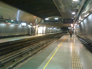
Cumming metro station
Metro station in Santiago, Chile
Distance: Approx. 306 meters
Latitude and longitude: -33.439075,-70.66863889
Cumming is an underground metro station on the Line 5 of the Santiago Metro, in Santiago, Chile. It is located underneath Catedral street in the commune of Santiago, between metro stations Quinta Normal and Santa Ana. The station opened on March 31, 2004, along with Quinta Normal station.

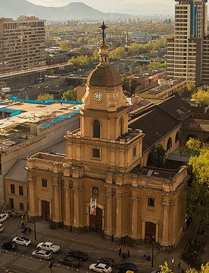
Basílica del Salvador
Church in Chile, Chile
Distance: Approx. 389 meters
Latitude and longitude: -33.4413,-70.661794
The Basílica del Salvador is a basilica located at the corner of Huérfanos Street and Almirante Barroso Street in the Barrio Brasil of Santiago de Chile. The basilica was designed by the German architect Teodoro Burchard in the Neo Gothic style. It was renovated by Josué Smith Solar in 1932.
Iglesia de Santa Ana (Santiago de Chile)
National monument of Chile
Distance: Approx. 736 meters
Latitude and longitude: -33.437806,-70.658715
The Iglesia de Santa Ana is a Catholic church in downtown Santiago de Chile. It is located at the northwest corner of Catedral and San Martín streets. The church was declared as a National Monument of Chile in 1970, within the category of Historic Monuments.

Pereira Palace
Building in Santiago, Chile
Distance: Approx. 709 meters
Latitude and longitude: -33.44,-70.6583
The Palacio Pereira is a historic neoclassical mansion located at the corner of San Martín and Huérfanos streets, in downtown Santiago, Chile. Built in the second half of the 19th century, it was declared a National Historic Monument in 1981, but this didn't prevent its deterioration. In 2011, under the first presidency of Sebastián Piñera, the government bought the building to transform it into the headquarters for the Dirección de Bibliotecas, Archivos y Museos (DIBAM) and the Consejo de Monumentos Nacionales (CMN).
Weather in this IP's area
overcast clouds
16 Celsius
15 Celsius
16 Celsius
17 Celsius
1015 hPa
54 %
1015 hPa
952 hPa
10000 meters
0.89 m/s
1.79 m/s
270 degree
100 %
07:34:14
19:37:42