Country:
Region:
City:
Latitude and Longitude:
Time Zone:
Postal Code:
IP information under different IP Channel
ip-api
Country
Region
City
ASN
Time Zone
ISP
Blacklist
Proxy
Latitude
Longitude
Postal
Route
Luminati
Country
ASN
Time Zone
America/Caracas
ISP
Net Uno, C.A.
Latitude
Longitude
Postal
IPinfo
Country
Region
City
ASN
Time Zone
ISP
Blacklist
Proxy
Latitude
Longitude
Postal
Route
db-ip
Country
Region
City
ASN
Time Zone
ISP
Blacklist
Proxy
Latitude
Longitude
Postal
Route
ipdata
Country
Region
City
ASN
Time Zone
ISP
Blacklist
Proxy
Latitude
Longitude
Postal
Route
Popular places and events near this IP address

Simón Bolívar University (Venezuela)
Distance: Approx. 5353 meters
Latitude and longitude: 10.4104,-66.8812
The Simón Bolívar University (Universidad Simón Bolívar in Spanish) or USB, is a public institution divided in two branches, one in Miranda state and one in Vargas state, with scientific and technological orientation. The Simón Bolívar University is arguably the most prestigious science and technology university in Venezuela and one of the most important ones in South America. It is the most selective higher education school in the country admitting only the 95th percentile of its standardized admission test.

Altamira, Caracas
Neighbourhood in Chacao Municipality, Miranda, Venezuela
Distance: Approx. 5367 meters
Latitude and longitude: 10.48333333,-66.83333333
Altamira is a neighborhood located in the Chacao municipality of Caracas, Venezuela. It has its own Metro Station, many hotels and restaurants, and it is an important business and residential center of the city. It is also an important tourist destination and cultural center in Caracas.

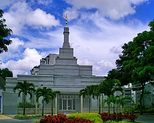
Caracas Venezuela Temple
Distance: Approx. 3942 meters
Latitude and longitude: 10.470849,-66.837293
The Caracas Venezuela Temple is the 96th operating temple of the Church of Jesus Christ of Latter-day Saints (LDS Church).
El Hatillo, Miranda
Place
Distance: Approx. 4331 meters
Latitude and longitude: 10.4333,-66.8
El Hatillo (Spanish: El Hatillo) is the seat of El Hatillo Municipality, Miranda, Venezuela.

Nuestra Señora del Rosario de Baruta
Place
Distance: Approx. 3782 meters
Latitude and longitude: 10.43222222,-66.87388889
Nuestra Señora del Rosario de Baruta is the seat of the Baruta Municipality in Miranda, Venezuela.

Las Mercedes, Caracas
Place
Distance: Approx. 3655 meters
Latitude and longitude: 10.46666667,-66.85
Las Mercedes is the largest district for shopping and leisure in Latin America. It is located at the Baruta Municipality, Miranda (state), Caracas. It has an estimated area of 93 hectares (0.93 square kilometers).
Colegio El Ángel
School in Chuao, Caracas, Venezuela
Distance: Approx. 4722 meters
Latitude and longitude: 10.477916,-66.840125
Unidad Educativa Colegio El Ángel U.E. C.E.A is a school in Chuao, Caracas, Venezuela. The school has its origins in the old "Santo Ángel de la Guarda" School, founded by the religious congregation of the same name. It was run by the nuns until 1976, year in which the school was sold and its name changed to the actual one.
Universidad Monteávila
University in Caracas, Venezuela
Distance: Approx. 4722 meters
Latitude and longitude: 10.477877,-66.841314
Universidad Monteávila (UMA) is a private, Roman Catholic - Opus Dei - University in Caracas, Venezuela. It was founded in 1998 by members of Opus Dei. Its education is humanities-based, offering majors in Law, Education, Business Administration and Social Communication.
1986 Eisenhower Trophy
Team golf tournament
Distance: Approx. 3517 meters
Latitude and longitude: 10.423,-66.81
The 1986 Eisenhower Trophy took place 22 to 25 October at the Lagunita Country Club in Caracas, Venezuela. It was the 15th World Amateur Team Championship for the Eisenhower Trophy. The tournament was a 72-hole stroke play team event with 39 four-man teams.
El Cafetal
Place in Miranda, Venezuela
Distance: Approx. 3535 meters
Latitude and longitude: 10.46666667,-66.83333333
El Cafetal is a neighborhood located in the Baruta Municipality of Caracas, Venezuela.
Las Minas de Baruta
Parish in Miranda, Venezuela
Distance: Approx. 2822 meters
Latitude and longitude: 10.44694444,-66.8625
Las Minas de Baruta is one of 3 parishes in the Baruta Municipality and one of 32 of Caracas, Venezuela.
1974 World Cup (men's golf)
Golf tournament
Distance: Approx. 3517 meters
Latitude and longitude: 10.423,-66.81
The 1974 World Cup took place 21–24 November at the Lagunita Country Club in Caracas, Venezuela. It was the 22nd World Cup event. The tournament was a 72-hole stroke play team event with 46 teams.
Weather in this IP's area
overcast clouds
20 Celsius
21 Celsius
18 Celsius
20 Celsius
1010 hPa
92 %
1010 hPa
877 hPa
10000 meters
0.5 m/s
0.72 m/s
305 degree
94 %
06:22:50
18:01:29

