Lookup
Country:
 Brazil
Region:
se
City:
umbaúba
Latitude and Longitude:
-11.383300,-37.657800
Time Zone:
America/Maceio
Postal Code:
IP information under different IP Channel
ip-api
Country
Region
City
ASN
Time Zone
ISP
Blacklist
Proxy
Latitude
Longitude
Postal
Route
IPinfo
Country
Region
City
ASN
Time Zone
ISP
Blacklist
Proxy
Latitude
Longitude
Postal
Route
MaxMind
Country
Region
City
ASN
Time Zone
ISP
Blacklist
Proxy
Latitude
Longitude
Postal
Route
Luminati
Country
BRRegion
se
City
aracaju
ASN
Time Zone
America/Maceio
ISP
ALOO TELECOM - FSF TECNOLOGIA SA
Latitude
-10.9738
Longitude
-37.1129
Postal
49000
db-ip
Country
Region
City
ASN
Time Zone
ISP
Blacklist
Proxy
Latitude
Longitude
Postal
Route
ipdata
Country
Region
City
ASN
Time Zone
ISP
Blacklist
Proxy
Latitude
Longitude
Postal
Route
Popular places and events near this IP address
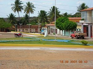
Umbaúba
Municipality in Northeast, Brazil
Distance: Approx. 58 meters
Latitude and longitude: -11.38277778,-37.65777778
Umbaúba is a municipality located in the Brazilian state of Sergipe. Its population was 25,550 (2020). Umbaúba covers 118.86 km2 (45.89 sq mi) and has a population density of 210 inhabitants per square kilometer.
Weather in this IP's area
Current Weather
clear sky
Current Temperature
20 Celsius
Feeling temperature
20 Celsius
lowest temperature
20 Celsius
Maximum temperature
20 Celsius
Atmospheric pressure
1019 hPa
humidity
92 %
Sea level pressure
1019 hPa
Surface atmospheric pressure
1002 hPa
visibility
10000 meters
Wind speed
1.98 m/s
gust
5.71 m/s
wind direction
106 degree
cloud
1 %
Sunrise time
05:24:01
Sunset time
17:26:53