Country:
Region:
City:
Latitude and Longitude:
Time Zone:
Postal Code:
IP information under different IP Channel
ip-api
Country
Region
City
ASN
Time Zone
ISP
Blacklist
Proxy
Latitude
Longitude
Postal
Route
Luminati
Country
Region
i
City
ibarra
ASN
Time Zone
America/Guayaquil
ISP
CEDIA
Latitude
Longitude
Postal
IPinfo
Country
Region
City
ASN
Time Zone
ISP
Blacklist
Proxy
Latitude
Longitude
Postal
Route
db-ip
Country
Region
City
ASN
Time Zone
ISP
Blacklist
Proxy
Latitude
Longitude
Postal
Route
ipdata
Country
Region
City
ASN
Time Zone
ISP
Blacklist
Proxy
Latitude
Longitude
Postal
Route
Popular places and events near this IP address
Imbabura Province
Province of Ecuador
Distance: Approx. 1734 meters
Latitude and longitude: 0.35,-78.13333333
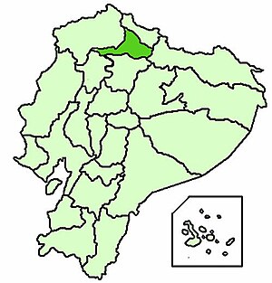
Imbabura (Spanish pronunciation: [imbaˈβuɾa]) is a province located in the Andes of northern Ecuador. The capital is Ibarra. The people of the province speak Spanish, and a large portion of the population also speaks the Imbaburan Kichwa variety of the Quechua language.

Ibarra, Ecuador
City in Imbabura, Ecuador
Distance: Approx. 1919 meters
Latitude and longitude: 0.36267778,-78.13066667
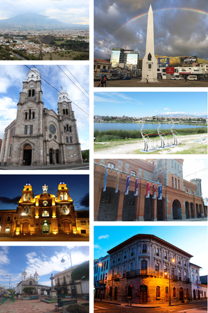
Ibarra (Spanish pronunciation: [iˈβara]; full name San Miguel de Ibarra; Quechua: Impapura) is a city in northern Ecuador and the capital of the Imbabura Province. It lies at the foot of the Imbabura Volcano and on the left bank of the Tahuando river. It is located about 70 kilometres (43 mi) northeast of Ecuador's capital Quito.
La Esperanza, Ecuador
Distance: Approx. 5176 meters
Latitude and longitude: 0.305,-78.12305556
La Esperanza (the name is Spanish for "hope") is a town and parish in northern Ecuador in Imbabura Province, Ibarra Canton. It lies at the north-eastern foot of Mount Imbabura volcano about 7 kilometres (4.3 mi) in straight line distance south of the city of Ibarra. La Esperanza parish had a population of 6,677 in the 2001 census and 7,363 in the 2010 census.

Roman Catholic Diocese of Ibarra
Roman Catholic diocese in Ecuador
Distance: Approx. 100 meters
Latitude and longitude: 0.352,-78.1174
The Roman Catholic Diocese of Ibarra (Latin: Dioecesis Ibarrensis) is a diocese located in the city of Ibarra in the ecclesiastical province of Quito in Ecuador.

Estadio Olímpico de Ibarra
Distance: Approx. 1006 meters
Latitude and longitude: 0.36021,-78.11853
Estadio Olímpico de Ibarra (English: Ibarra Olympic Stadium) is a multi-use stadium in Ibarra, Ecuador. It is currently used mostly for football matches and is the home stadium of Imbabura Sporting Club of the Serie A de Ecuador. The stadium holds 18,600 spectators and opened in 1988.

Autodromo Internacional de Yahuarcocha
Distance: Approx. 3977 meters
Latitude and longitude: 0.38,-78.09666667
The Autódromo Internacional José Tobar, formerly known as the Autodromo Internacional de Yahuarcocha, is a motorsport circuit located in Ibarra, Ecuador, around the lake Yawarkucha. It has hosted events in the Formula Renault series. During the 1960s the construction of the new and current layout was ordered and it came into shape and was finished by the start of the 1970s, with a new and smaller layout due to the old layout being ruled too dangerous given the danger of crashing in water.

1868 Ecuador earthquakes
Distance: Approx. 8305 meters
Latitude and longitude: 0.31,-78.18
The 1868 Ecuador earthquakes occurred at 19:30 UTC on August 15 and 06:30 UTC on 16 August 1868. They caused severe damage in the northeastern part of Ecuador and in southwestern Colombia. They had an estimated magnitude of 6.3 and 6.7 and together caused up to 70,000 casualties.
Yawarkucha
Distance: Approx. 3004 meters
Latitude and longitude: 0.37203056,-78.10063889
Yawarkucha or Yawar Kucha (Kichwa yawar blood, kucha lake, "blood lake"), Hispanicized spellings Yaguarcocha, Yahuarcocha) is a lake in Ecuador located in the eastern outskirts of the city of Ibarra in Imbabura Province, Ibarra Canton. The lake is about 2 kilometres (1.2 mi) long and wide and has an elevation of 2,190 metres (7,190 ft) above sea level. The lake was formed from glacial meltwater about 10,000 BCE. The scenic lake is a popular tourist attraction.
San Antonio de Ibarra
City in Imbabura, Ecuador
Distance: Approx. 1919 meters
Latitude and longitude: 0.36267778,-78.13066667
San Antonio de Ibarra is a city in northern Ecuador that lies at the foot of the Imbabura Volcano and on the left bank of the Tahuando River in Imbabura Province. It is about 7 kilometres (4.3 mi) from the provincial capital of Ibarra and about 70 kilometres (43 mi) northeast of Ecuador's capital Quito.
Atahualpa Airport
Airport
Distance: Approx. 2456 meters
Latitude and longitude: 0.33888889,-78.13611111
Atahualpa Airport (ICAO: SEIB) was an airport formerly serving the town of Ibarra in Imbabura Province, Ecuador. The Google Earth Historical Image for 6/7/2011 shows a 1,950 metres (6,400 ft) north/south asphalt runway. The 9/1/2015 image shows the runway gone and the land under commercial and residential development.
Inca-Caranqui
Archaeological site in Ecuador
Distance: Approx. 3285 meters
Latitude and longitude: 0.32194444,-78.12166667
The Inca-Caranqui archaeological site is located in the village of Caranqui on the southern outskirts of the city of Ibarra, Ecuador. The ruin is located in a fertile valley at an elevation of 2,299 metres (7,543 ft). The region around Caranqui, extending into the present day country of Colombia, was the northernmost outpost of the Inca Empire and the last to be added to the empire before the Spanish conquest of 1533.
Battle of Ibarra (1812)
Part of the Ecuadorian War of Independence
Distance: Approx. 1964 meters
Latitude and longitude: 0.36277778,-78.13111111
The First Battle of Ibarra occurred in the vicinity of the city of Ibarra, Ecuador, between 27 November and 1 December 1812. The event, which is part of the Spanish American Wars of Independence, pitted the troops of the State of Quito against those of the Spanish Empire. The battle was a decisive victory for the Spanish and resulted in the disappearance of the short-lived nation that had been born in the territory of the Royal Audiencia of Quito, after the Quito revolt of 10 August 1809, which had declared itself independent from Spain on 11 October 1811.
Weather in this IP's area
overcast clouds
16 Celsius
16 Celsius
16 Celsius
16 Celsius
1015 hPa
92 %
1015 hPa
788 hPa
10000 meters
0.86 m/s
1.33 m/s
72 degree
92 %
05:53:01
17:59:08


