Country:
 Colombia
Region:
City:
Latitude and Longitude:
Time Zone:
Postal Code:
IP information under different IP Channel
ip-api
Country
Region
City
ASN
Time Zone
ISP
Blacklist
Proxy
Latitude
Longitude
Postal
Route
IPinfo
Country
Region
City
ASN
Time Zone
ISP
Blacklist
Proxy
Latitude
Longitude
Postal
Route
MaxMind
Country
Region
City
ASN
Time Zone
ISP
Blacklist
Proxy
Latitude
Longitude
Postal
Route
Luminati
Country
COASN
Time Zone
America/Bogota
ISP
COLUMBUS-NETWORKS
Latitude
Longitude
Postal
db-ip
Country
Region
City
ASN
Time Zone
ISP
Blacklist
Proxy
Latitude
Longitude
Postal
Route
ipdata
Country
Region
City
ASN
Time Zone
ISP
Blacklist
Proxy
Latitude
Longitude
Postal
Route
Popular places and events near this IP address

Huila Department
Department of Colombia
Distance: Approx. 7604 meters
Latitude and longitude: 2.99861111,-75.30444444
Huila (Spanish pronunciation: [ˈwila]) is one of the departments of Colombia. It is located in the southwest of the country, and its capital is Neiva.

Neiva, Huila
Municipality and city in Andean, Colombia
Distance: Approx. 0 meters
Latitude and longitude: 2.93448333,-75.2809
Neiva (Spanish pronunciation: [ˈnejβa]) is the capital and most populated city of the Department of Huila, south central Colombia. It is located in the valley of the Magdalena River with a municipal population of 357,392. It is one of the most important cities in southern Colombia, mainly because of its strategic geographical location.

Estadio Guillermo Plazas Alcid
Distance: Approx. 168 meters
Latitude and longitude: 2.935824,-75.280206
Estadio Guillermo Plazas Alcid is a multi-purpose stadium in Neiva, Colombia. It is currently used mostly for football matches. The stadium has a capacity of 22,000 people and was built in 1980.

Benito Salas Airport
Airport
Distance: Approx. 2272 meters
Latitude and longitude: 2.95,-75.29416667
Benito Salas Airport (Spanish: Aeropuerto Benito Salas, IATA: NVA, ICAO: SKNV) is an airport that serves the city of Neiva, the capital of the Huila Department in Colombia. It was named after Benito Salas Vargas, a military and social leader during Colombia's (then known as New Granada) independence war (1810–1819). The airport is in a rebuilding process that includes a new control tower and a new building with garages.
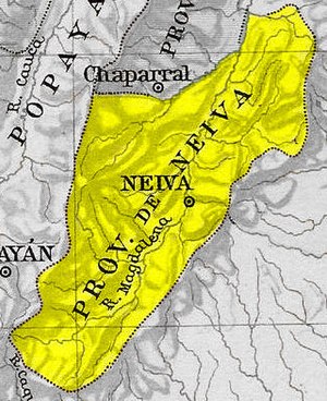
Neiva Province
Distance: Approx. 5838 meters
Latitude and longitude: 2.98333333,-75.3
Neiva Province was one of the provinces of Gran Colombia. With the 1824 changes in the subdivisions of Gran Colombia, it became part of the Cundinamarca Department.

Immaculate Conception Cathedral, Neiva
Church in Neiva, Colombia
Distance: Approx. 1331 meters
Latitude and longitude: 2.92586111,-75.28919444
The Immaculate Conception Cathedral Also Neiva Cathedral Is the name given to a religious building affiliated with the Roman Catholic Church dedicated to the Virgin Mary in her invocation of the Immaculate Conception. It is located in the city of Neiva in the department of Huila in the southwestern part of the South American country of Colombia. The temple that follows the Roman or Latin rite is the mother church of the Diocese of Neiva (Dioecesis Neivensis) that was established in 1972 by Pope Paul VI. It was built in a Gothic style that for a long time dominated the constructions of the city.
Neiva Regional Archaeological Museum
Archaeological museum in Neiva, Colombia
Distance: Approx. 1425 meters
Latitude and longitude: 2.937433,-75.293368
The Neiva Regional Archaeological Museum (Spanish: Museo Arqueológico Regional de Neiva) is an archeological museum in Neiva, Colombia. The museum is dedicated to the conservation of the cultural heritage of the Department of Huila. The museum is located in the José Eustasio Rivera Convention Center.
Monumento a la Raza (Neiva)
Monument in Neiva, Colombia
Distance: Approx. 2585 meters
Latitude and longitude: 2.94258333,-75.30269444
The Monumento a la Raza y al Mestizaje (lit. 'Monument to the Race and to Mestizo-ship'), simply known as the Monumento a la Raza, was a concrete-and-steel outdoor sculpture and monument in the city of Neiva, Huila, Colombia. It featured a Spanish conquistador, an indigenous woman, and their mixed-race infant, all of whom were partially naked. Olmo Guillermo Liévano, the city's mayor, unveiled it on a roundabout at the South Colombian University on 24 May 1978, to commemorate the 366th year of the city's founding.
Weather in this IP's area
few clouds
25 Celsius
26 Celsius
25 Celsius
25 Celsius
1013 hPa
83 %
1013 hPa
960 hPa
10000 meters
2.06 m/s
150 degree
20 %
05:44:28
17:46:51