Country:
Region:
City:
Latitude and Longitude:
Time Zone:
Postal Code:
IP information under different IP Channel
ip-api
Country
Region
City
ASN
Time Zone
ISP
Blacklist
Proxy
Latitude
Longitude
Postal
Route
Luminati
Country
ASN
Time Zone
America/Guayaquil
ISP
CENTROSUR
Latitude
Longitude
Postal
IPinfo
Country
Region
City
ASN
Time Zone
ISP
Blacklist
Proxy
Latitude
Longitude
Postal
Route
db-ip
Country
Region
City
ASN
Time Zone
ISP
Blacklist
Proxy
Latitude
Longitude
Postal
Route
ipdata
Country
Region
City
ASN
Time Zone
ISP
Blacklist
Proxy
Latitude
Longitude
Postal
Route
Popular places and events near this IP address

Azuay Province
Province of Ecuador
Distance: Approx. 3716 meters
Latitude and longitude: -2.88333333,-79
Azuay (Spanish pronunciation: [aˈswaj] ), Province of Azuay is a province of Ecuador, created on 25 June 1824. It encompasses an area of 8,171 square kilometres (3,155 sq mi). Its capital and largest city is Cuenca.

Cuenca, Ecuador
City in Azuay, Ecuador
Distance: Approx. 3987 meters
Latitude and longitude: -2.89741389,-79.00448056
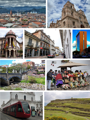
Cuenca, officially Santa Ana de los Ríos de Cuenca, is an Ecuadorian city, head of the canton of the same name and capital of the province of Azuay, as well as its largest and most populated city. It is crossed by the Tomebamba, Tarqui, Yanuncay and Machángara rivers, in the south-central inter-Andean region of Ecuador, in the Paute river basin, at an altitude of 2,538 meters above sea level and with a temperate Andean climate averaging 16.3 °C. It has been locally called "Cuenca of the Andes" or "Athens of Ecuador" for its architecture, its cultural diversity, its contribution to Ecuadorian arts, sciences and literature, and for being the birthplace of many illustrious figures of Ecuadorian society. At the 2022 census it had a population of 596,101 inhabitants, making it the third most populous city in the country behind Guayaquil and Quito.
Tumebamba
Former Inca city
Distance: Approx. 3368 meters
Latitude and longitude: -2.90666667,-78.99666667
Tumebamba, Tomebamba (hispanicized spellings), or Tumipampa (Kichwa for "Knife Field", Tumi: Knife, Pampa: Field) was a former main regional city in the Inca Empire. Tumebamba was chosen by the Emperor Huayna Capac (ruled 1493–1525) to be the Inca northern capital. The city was largely destroyed during the civil war between Huáscar and Atahualpa shortly before the arrival of the Spanish conquistadors in 1532.
Politecnica Salesiana University
Distance: Approx. 2515 meters
Latitude and longitude: -2.8864,-78.9896
The Politecnica Salesiana University in Ecuador is an institution of higher education and Christian inspiration with Catholic character and a Salesian. The university is characterized by its opportunities for youth, especially from the poor sectors.
Old Cathedral of Cuenca
UNESCO World Heritage Site
Distance: Approx. 3920 meters
Latitude and longitude: -2.897837,-79.00385
The Sagrario Church (Shrine Church) - also known as the Old Cathedral of Cuenca is a temple whose construction began in the mid-16th century, and was considered the main Spanish place of worship during the time of Spanish colonization in Cuenca (Ecuador). Today it functions as the Museum of Religious Art, known for its wide variety of altars and the history it offers. It is located in the center of the city of Cuenca, and one of its most emblematic museums, which is located in Parque Calderón, in front of the New Cathedral.
Machángara River
River in Ecuador
Distance: Approx. 1460 meters
Latitude and longitude: -2.88204,-78.96696
The Machángara River is a river located in the southern Andes of Ecuador.
Matadero River
River in Ecuador
Distance: Approx. 2363 meters
Latitude and longitude: -2.88444444,-78.95027778
The Matadero River is a river of Ecuador.

Atahualpa Canton
Canton in El Oro Province, Ecuador
Distance: Approx. 3971 meters
Latitude and longitude: -2.9,-78.93333333
Atahualpa Canton is a canton of Ecuador, located in the El Oro Province. Its capital is the town of Paccha. Its population at the 2001 census was 5,479.
Paccha
Parish in Azuay Province, Ecuador
Distance: Approx. 3971 meters
Latitude and longitude: -2.9,-78.93333333
Paccha (Hispanicized spelling of the Kichwa word pakcha meaning "waterfall") is a town and parish in Cuenca Canton, Azuay Province, Ecuador. The parish covers an area of 25.6 km2 and according to the 2001 Ecuadorian census it had a population total of 5,311.

TAME Flight 173
1983 passenger plane crash in Cuenca, Ecuador
Distance: Approx. 3912 meters
Latitude and longitude: -2.86536111,-78.94986111
TAME Flight 173, a Boeing 737-2V2 Advanced operated by Ecuador's national airline TAME, flying on a domestic route from the now-closed Mariscal Sucre International Airport in Quito to Mariscal Lamar International Airport in Cuenca, crashed on 11 July 1983 into a hill during final approach just 1 mile (1.6 km; 0.87 nmi) from its final destination, killing all 119 people on board. The crash was the deadliest crash in the history of TAME, and it remains as the deadliest aircraft accident in the history of Ecuador. An investigation later determined that the flight crashed due to the flight crew's lack of experience on the aircraft type, which caused a controlled flight into terrain.

Azuay Department
Distance: Approx. 3716 meters
Latitude and longitude: -2.88333333,-79
Azuay Department was created with the 1824 reform of the subdivisions of Gran Colombia. Cuenca Province - Capital: Cuenca. Cantons: Cuenca, Cañar, Gualaseo y Girón.

Pumapungo Museum
Ethnographic & Art museum in Cuenca, Ecuador
Distance: Approx. 3381 meters
Latitude and longitude: -2.905964,-78.997076
The Pumapungo Museum (Spanish: Museo Pumapungo) is an ethnographic and art museum in Cuenca, Ecuador.
Weather in this IP's area
overcast clouds
14 Celsius
13 Celsius
14 Celsius
14 Celsius
1016 hPa
91 %
1016 hPa
763 hPa
10000 meters
0.78 m/s
1.14 m/s
35 degree
100 %
05:52:43
18:06:22

