190.123.16.113 - IP Lookup: Free IP Address Lookup, Postal Code Lookup, IP Location Lookup, IP ASN, Public IP
Country:
 Saint Barthélemy
Region:
City:
Location:
Time Zone:
Postal Code:
ISP:
ASN:
language:
User-Agent:
Proxy IP:
Blacklist:
IP information under different IP Channel
ip-api
Country
Region
City
ASN
Time Zone
ISP
Blacklist
Proxy
Latitude
Longitude
Postal
Route
db-ip
Country
Region
City
ASN
Time Zone
ISP
Blacklist
Proxy
Latitude
Longitude
Postal
Route
IPinfo
Country
Region
City
ASN
Time Zone
ISP
Blacklist
Proxy
Latitude
Longitude
Postal
Route
IP2Location
190.123.16.113Country
blRegion
saint barthelemy
City
gustavia
Time Zone
America/St_Barthelemy
ISP
Language
User-Agent
Latitude
Longitude
Postal
ipdata
Country
Region
City
ASN
Time Zone
ISP
Blacklist
Proxy
Latitude
Longitude
Postal
Route
Popular places and events near this IP address

Gustavia, Saint Barthélemy
Largest city in Saint Barthélemy
Distance: Approx. 206 meters
Latitude and longitude: 17.89790833,-62.85055556
Gustavia (, French: [ɡystavja], Swedish: [ˈɡɵ̂sːtaviːa]) is the main town and capital of the island of Saint Barthélemy. Originally called Le Carénage, it was renamed in honor of King Gustav III of Sweden.
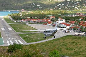
Gustaf III Airport
Airport in St. Jean
Distance: Approx. 1111 meters
Latitude and longitude: 17.90444444,-62.84388889
Gustaf III Airport (IATA: SBH, ICAO: TFFJ), also known as Saint Barthélemy Airport, Rémy de Haenen Airport, sometimes as St. Jean Airport (French: Aérodrome de St Jean), is a public use airport located in the village of St. Jean on the Caribbean island of Saint Barthélemy.

Le Château, Saint Barthélemy
Quartier in Saint Barthélemy, France
Distance: Approx. 1418 meters
Latitude and longitude: 17.90611111,-62.84138889
Le Château (French pronunciation: [lə ʃato]) is a quartier of Saint Barthélemy in the Caribbean. It is located in the northern part of the island. The airport runway is located nearby.
Aéroport
Quartier in Saint Barthélemy, France
Distance: Approx. 1068 meters
Latitude and longitude: 17.90333333,-62.84305556
Aéroport (French pronunciation: [aeʁɔpɔʁ] ) is the place of Gustaf III Airport, in quartier Saint-Jean of Saint Barthélemy in the Caribbean. It is located in the northern part of the island. As the name suggests, it contains the airport runway.
Public, Saint Barthélemy
Quartier in Saint Barthélemy, France
Distance: Approx. 812 meters
Latitude and longitude: 17.90333333,-62.85138889
Public (French pronunciation: [pyblik] ) is a quartier of Saint Barthélemy in the Caribbean. In the western part of the island, situated 180 km to the North-West of St.John's, around 90 km North-West from the St. Kitts and Nevis border.
Col de la Tourmente
Quartier in Saint Barthélemy, France
Distance: Approx. 889 meters
Latitude and longitude: 17.90416667,-62.84916667
Col de la Tourmente (French pronunciation: [kɔl də la tuʁmɑ̃t]) is a quartier of Saint Barthélemy in the Caribbean. It is located in the western part of the island.
La Pointe, Saint Barthélemy
Quartier in Saint Barthélemy, France
Distance: Approx. 372 meters
Latitude and longitude: 17.89833333,-62.8525
La Pointe (French pronunciation: [la pwɛ̃t]) is a quartier of Saint Barthélemy in the Caribbean. It is located in the western part of the island at the end of Gustavia.
Lurin
Quartier of Saint Barthélemy in the Caribbean
Distance: Approx. 1144 meters
Latitude and longitude: 17.8925,-62.83972222
Lurin (French pronunciation: [lyʁɛ̃]) is a quartier of Saint Barthélemy in the Caribbean. It is east of Gustavia and is one of the larger quartiers on the island.
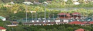
Stade de Saint-Jean
Distance: Approx. 1074 meters
Latitude and longitude: 17.902,-62.8417
Stade de Saint-Jean is a multi-purpose stadium in the Saint-Jean quarter of Saint Barthélemy, an overseas collectivity of France in the Caribbean. It is the only stadium on the island and currently hosts matches of local rugby teams and the Saint Barthélemy national football team.

Church of Our Lady of the Assumption, Gustavia
Church in Saint Barthélemy, France
Distance: Approx. 231 meters
Latitude and longitude: 17.8947,-62.8483
The Church of Our Lady of the Assumption (French: L'église Notre-Dame de l'Assomption) or the Catholic Church of Gustavia (Église catholique de Gustavia) is a religious building dating from the nineteenth century and is located in the town of Gustavia on the island of Saint Barthelemy, a dependency of France in the Caribbean Sea. The bell tower, the square and other structures are protected with the title of Historic Monuments. The Church of Our Lady of the Assumption was finished in 1829.

Air Caraïbes Flight 1501
2001 aviation incident
Distance: Approx. 1142 meters
Latitude and longitude: 17.90625,-62.85194444
Air Caraïbes Flight 1501 (TX1501/FWI1501) was a scheduled international passenger flight, flying from Saint Martin Airport in the Dutch overseas territory of Sint Maarten to Saint Barthélemy Airport which was in the French overseas region of Guadeloupe at that time. The flight was operated by Air Caraïbes, a Caribbean regional airline, using a de Havilland Canada DHC-6-300 Twin Otter. On 24 March 2001, during an approach to Saint Barthélemy Airport, the DHC-6 Twin Otter banked steeply to the left and crashed into a house, killing all 19 passengers and crew on board.

Gustavia Lighthouse
Lighthouse on Saint Barthélemy in the French West Indies
Distance: Approx. 571 meters
Latitude and longitude: 17.901061,-62.851533
The Gustavia Lighthouse is a 20th-century lighthouse located in Gustavia, the capital of Saint Barthélemy in the French West Indies. It was constructed in 1961 on the grounds of Fort Gustav, overlooking the Gustavia harbor. Today the lighthouse is a popular location for tourists, hikers, and photographers, as well as a site for viewing regattas, such as the St Barths Bucket Regatta.
Weather in this IP's area
clear sky
28 Celsius
31 Celsius
28 Celsius
28 Celsius
1018 hPa
71 %
1018 hPa
1018 hPa
10000 meters
4.47 m/s
8.49 m/s
46 degree
10 %