190.121.137.188 - IP Lookup: Free IP Address Lookup, Postal Code Lookup, IP Location Lookup, IP ASN, Public IP
Country:
Region:
City:
Location:
Time Zone:
Postal Code:
ISP:
ASN:
language:
User-Agent:
Proxy IP:
Blacklist:
IP information under different IP Channel
ip-api
Country
Region
City
ASN
Time Zone
ISP
Blacklist
Proxy
Latitude
Longitude
Postal
Route
db-ip
Country
Region
City
ASN
Time Zone
ISP
Blacklist
Proxy
Latitude
Longitude
Postal
Route
IPinfo
Country
Region
City
ASN
Time Zone
ISP
Blacklist
Proxy
Latitude
Longitude
Postal
Route
IP2Location
190.121.137.188Country
Region
new mexico
City
raton
Time Zone
America/Denver
ISP
Language
User-Agent
Latitude
Longitude
Postal
ipdata
Country
Region
City
ASN
Time Zone
ISP
Blacklist
Proxy
Latitude
Longitude
Postal
Route
Popular places and events near this IP address

Raton, New Mexico
City in New Mexico, United States
Distance: Approx. 3317 meters
Latitude and longitude: 36.87361111,-104.44
Raton ( rə-TONE) is a city in and the county seat of Colfax County in northeastern New Mexico, United States. The city is located just south of Raton Pass. The city is also located about 6.5 miles south of the New Mexico–Colorado border and 85 miles west of Texas.

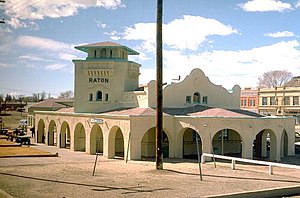
Raton station
Train station in Raton, New Mexico, U.S.
Distance: Approx. 291 meters
Latitude and longitude: 36.901,-104.4378
Raton is an active railroad station in the city of Raton, Colfax County, New Mexico, United States. Located at 201 South First Street, the station serves Amtrak's Southwest Chief. Connections are also available to Denver, Colorado via Amtrak Thruway bus service.

Raton Downtown Historic District
Historic district in New Mexico, United States
Distance: Approx. 440 meters
Latitude and longitude: 36.89944444,-104.43916667
The Raton Downtown Historic District is a historic district listed on the National Register of Historic Places in Raton, New Mexico, USA. The district, when first listed in 1977, is bounded on the north by Clark Avenue and on the south by Rio Grande Avenue. On the east, the district is bounded by First Street, and on the west the district is bounded by Third Street. The district covers about 200 acres (81 ha) and contains 95 significant buildings.

Colfax County Courthouse (Raton, New Mexico)
United States historic place
Distance: Approx. 155 meters
Latitude and longitude: 36.90416667,-104.44055556
The Colfax County Courthouse is a building listed on the National Register of Historic Places. The courthouse is located at 230 North 3rd Street in Raton, New Mexico. The courthouse, built in 1936, is a five-story blond, brick building with a hipped tile roof on the top story and flat roofs on the lower portions.
Sugarite Canyon State Park
State park in New Mexico, United States
Distance: Approx. 7796 meters
Latitude and longitude: 36.95916667,-104.38611111
Sugarite Canyon State Park is a state park of New Mexico, United States, featuring a historic early-20th century coal-mining camp and natural scenery at the border of the Rocky Mountains and the Great Plains. The park is located on the Colorado–New Mexico state line 6 miles (9.7 km) in Colfax County, New Mexico, northeast of Raton.
Raton High School
Public high school in Raton, New Mexico, United States
Distance: Approx. 2134 meters
Latitude and longitude: 36.88694444,-104.45138889
Raton High School (RHS) is a public senior high school in Raton, New Mexico. It is a part of the Raton Public Schools district.

Original Townsite Historic District
United States historic place
Distance: Approx. 596 meters
Latitude and longitude: 36.89944444,-104.44361111
The Original Townsite Historic District in Raton, New Mexico is a historic district which was listed on the National Register of Historic Places in 2008. The district is a 120 acres (49 ha) roughly bounded by Clark & Cimmaron Avenues, S. 2nd & S. 7th Streets within Raton, a town that was platted in 1880. The district included 360 contributing buildings, a contributing structure, and a contributing structure.
El Raton Theater
United States historic place
Distance: Approx. 86 meters
Latitude and longitude: 36.90416667,-104.43916667
The El Raton Theater, at 115 N. Second St. in Raton, New Mexico, is a theatre built in 1930. It was listed on the National Register of Historic Places in 2007.
Kearny School
United States historic place
Distance: Approx. 976 meters
Latitude and longitude: 36.895,-104.44222222
The Kearny School, at 800 S. 3rd St. in Raton, New Mexico, was built in 1936. It was listed on the National Register of Historic Places in 1996.
Columbian School (Raton, New Mexico)
United States historic place
Distance: Approx. 759 meters
Latitude and longitude: 36.91,-104.43694444
The Columbian School in Raton, New Mexico, at 700 N. 2nd St., is a Moderne-style school which was built as a Works Progress Administration project in 1939. It was listed on the National Register of Historic Places in 1996. It was designed by architect Willard C. Kruger.
Longfellow School (Raton, New Mexico)
United States historic place
Distance: Approx. 725 meters
Latitude and longitude: 36.89805556,-104.43444444
The Longfellow School in Raton, New Mexico, at 700 E. 4th St., is an elementary school which was built in 1939 as a Works Progress Administration project. It was listed on the National Register of Historic Places in 1996. It was designed by architect William C. Kruger in a modest Moderne style.
Weather in this IP's area
clear sky
-10 Celsius
-16 Celsius
-10 Celsius
-10 Celsius
1007 hPa
57 %
1007 hPa
771 hPa
10000 meters
3.6 m/s
360 degree


